Allan, Queensland
Allan is a rural locality in the Southern Downs Region, Queensland, Australia.[1] In the 2016 census, Allan had a population of 87 people.[2]
| Allan Queensland | |||||||||||||||
|---|---|---|---|---|---|---|---|---|---|---|---|---|---|---|---|
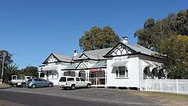 Darling Downs Hotel erected 1920s | |||||||||||||||
| Postcode(s) | 4370 | ||||||||||||||
| Area | 8.7 km2 (3.4 sq mi) | ||||||||||||||
| Location | |||||||||||||||
| LGA(s) | Southern Downs Region | ||||||||||||||
| State electorate(s) | Southern Downs | ||||||||||||||
| Federal Division(s) | Maranoa | ||||||||||||||
| |||||||||||||||
Geography
The Cunningham Highway passes through the locality. So does Sandy Creek, a major watercourse which is a tributary of the Condamine River. A section of the eastern boundary is marked by the Condamine River.
History
The locality is named after botanist and explorer Allan Cunningham.[3] The district was formerly known as Sandy Creek after the local creek.
A number of hotels were built at Sandy Creek in 1866. Adam Smith built the Darling Downs Hotel in 1875. It operated as a coach stop for changing horses from 1880 until the Allan railway station opened in 1904. In the 1920s, the old Darling Downs Hotel was replaced with the current building.[4]
The Allan State School opened on 13 May 1872 as the Sandy Creek Provisional School. The school and residence were built by W. Wallace and H. Marshall for £304/10/0. In 1929 it became Allan State School. It closed in December 1967.[5][6][7]
Heritage listings
The Southern Downs Local Heritage Register lists the following sites in Allan:[8]
- 280 Sandy Creek Road: Allan State School (formerly Sandy Creek School)
- 345 Sandy Creek Road: Darling Downs Hotel
Geography
The land is used for agricultural purposes, both crops and grazing. The Condamine River forms the north-eastern boundary of the locality, while Sandy Creek flows from the locality.[9]
The Cunningham Highway passes through the locality from the south-east towards the west. The South Western railway line runs roughly parallel to the south of the highway. Major arterial roads in the locality are Sandy Creek Road which runs from the highway north-west towards neighbouring Leslie. The Leslie Dam Road runs south from the highway towards the Leslie Dam.[9]
References
- "Allan - locality in Southern Downs Region (entry 45903)". Queensland Place Names. Queensland Government. Retrieved 5 November 2019.
- Australian Bureau of Statistics (27 June 2017). "Allan (SSC)". 2016 Census QuickStats. Retrieved 20 October 2018.

- "Allan (entry 45903)". Queensland Place Names. Queensland Government. Retrieved 13 March 2014.
- "Cultural Heritage Study - Inventory of Surveyed Places (Part 1)" (PDF). Southern Downs Regional Council. p. 112. Retrieved 13 June 2015.
- "Opening and closing dates of Queensland Schools". Queensland Government. Retrieved 18 April 2019.
- "Agency ID 6347, Allan State School". Queensland State Archives. Retrieved 14 June 2015.
- "Cultural Heritage Study - Inventory of Surveyed Places (Part 1)" (PDF). Southern Downs Regional Council. p. 110. Retrieved 14 June 2015.
- "Local Heritage Register" (PDF). Southern Downs Regional Council. Retrieved 13 June 2015.
- "Queensland Globe". State of Queensland. Retrieved 13 June 2015.