Albion, Victoria
Albion is a suburb of Melbourne, Victoria, Australia, 14 km north-west from Melbourne's Central Business District, located within the City of Brimbank local government area. Albion recorded a population of 4,731 at the 2016 census.
| Albion Melbourne, Victoria | |||||||||||||||
|---|---|---|---|---|---|---|---|---|---|---|---|---|---|---|---|
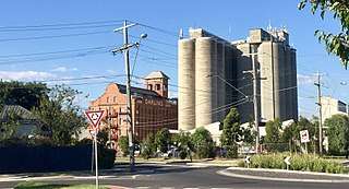 The John Darling & Son flour mill in Albion, Victoria. | |||||||||||||||
 Albion | |||||||||||||||
| Coordinates | 37.781°S 144.8145°E | ||||||||||||||
| Population | 4,731 (2016)[1] | ||||||||||||||
| • Density | 1,890/km2 (4,900/sq mi) | ||||||||||||||
| Established | 1849 | ||||||||||||||
| Postcode(s) | 3020 | ||||||||||||||
| Area | 2.5 km2 (1.0 sq mi) | ||||||||||||||
| Location | 14 km (9 mi) from Melbourne | ||||||||||||||
| LGA(s) | City of Brimbank | ||||||||||||||
| State electorate(s) | St Albans | ||||||||||||||
| Federal Division(s) | Fraser | ||||||||||||||
| |||||||||||||||
Albion is bordered on the north by the M80 Western Ring Road, the south by Forrest Street, the west by Kororoit Creek and the east by Anderson Road and the Melbourne Metro train line between Anderson Road and the M80 Western Ring Road.
History
The Wurundjeri people were the custodians of the land in the Port Phillip Bay region, including the City of Brimbank, for over 40,000 years before European settlement. Albion lies within the area occupied by the Kurung-Jang-Balluk and Marin-Balluk clans of the Wurundjeri people (also known as the Woiwurung language group), who form part of the larger Kulin Nation. Other groups who occupied land in the area include the Yalukit-Willam and Marpeang-Bulluk clans.
Following European settlement, the area was originally called Darlington, from at least 1860 to about 1890.[2] The area originally known as Albion was directly west of Duke Street, as can be noted by the many streets there named after English counties and placenames – Albion being an ancient name for the island of Great Britain.
Albion station opened on 5 January 1860 as Albion and Darlington but closed a year later.[3] It was not until 1919 that a new station was opened on the same site with the name Albion station.[3]
In March 1885 the Albion Quarrying Company began its operations in the area[4][5] The disused Albion quarry, accessed from Hulett St, Sunshine was the location for AC/DC's Jailbreak music video.[6][7]
It was H. V. McKay of Sunshine Harvester Works fame who bought land to develop a residential community for his workers in first decades on the 20th century. His concept for Sunshine was the Sunshine Estate: a community developed according to the ideals of the Garden city movement, an influential town planning movement of the late 19th and early 20th centuries.[8][9] This area was mainly in what is now called Albion. McKay's own residence, The Gables, was in Talmage Street (where the cul-de-sac The Gables now is) until it was consumed by fire and subsequently demolished.
Today
Albion has many period homes such as California bungalows and 1940s weatherboard houses. In the eastern parts of Albion, many of the oldest homes were built by H. V. McKay as part of his Sunshine Estate, a housing community built according to the influential early 20th Century Garden city movement.
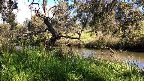
Kororoit Creek provides the western border for Albion. Along it runs the Kororoit Creek Trail which runs all the way southwards to meet the Federation Trail in Brooklyn.
Stony Creek lies on the eastern edge of Albion, close to Anderson Road. As of 2013, the creek's environmental state west of Anderson Rd is very poor as it has long been converted to nothing more than a concrete stormwater drain for this particular section of its course.
A notable landmark of Albion is the red brick John Darling and Son Flour Mill built in 1922. It is just to the south of Ballarat Rd, next to Albion train station.[10]
Population
In the 2016 Census, there were 4,731 people in Albion. Of these 54.2% were male and 45.8% were female. Aboriginal and/or Torres Strait Islander people made up 0.8% of the population. The median age of people in Albion was 33 years. Children aged 0 - 14 years made up 15.4% of the population and people aged 65 years and over made up 12.3% of the population. The most common ancestries in Albion were English 13.3%, Australian 12.8%, Indian 7.0%, Vietnamese 5.6% and Chinese 5.1%.[11]
Transportation
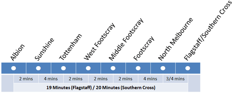
- Melbourne Metro (Train) Services. Albion railway station is on the Watergardens/Sunbury line and lies in the PTV zones 1+2 overlap.
- Bus Services. Metropolitan buses service the suburb and Albion station. These include:
- 215 Caroline Springs – Highpoint SC via Albion RS, Burnside SC (every day). Operated by Transdev Melbourne.
- 400 Sunshine - Laverton via Deer Park RS, Dame Phyllis Frost Centre, Metropolitan Remand Centre, and Port Phillip Prison (every day). Operated by Sita Buslines and CDC Melbourne.
- 451 Sunshine - Deer Park North via Deer Park RS (every day). Operated by Sita Buslines.
- 456 Sunshine – Woodgrove SC via Albion RS, Burnside SC, Caroline Springs, Melton (every day). Operated by Sita Buslines.
- 903 Altona – Mordialloc SC via Essendon, Northland SC, Box Hill, Chadstone SC (every day). Operated by Ventura Bus Lines.
- Cycling. Cyclists in Albion are represented by BrimBUG, the Brimbank Bicycle User Group.[12] The Kororoit Creek Trail runs along Albion's western perimeter.
Education and Childcare
Albion has a dedicated kindergarten facility in additional to two primary schools all located on Adelaide St.
- Albion Kindergarten. Albion Kindergarten offers a four year old kindergarten program. To be eligible for four year old kindergarten a child must turn four years of age on or before 30th of April in the year of attendance.[13]
- Albion Primary School. Albion Primary School was opened in 1926 and has a current enrolment of approximately 200 students. The school has four main buildings with all classrooms providing air conditioning and interactive screens. The original school building houses classrooms, art room and the administration offices. The newest building has classrooms and some small group/office spaces. The red brick building at the back of the courtyard includes a library, canteen and a multi-purpose room used for indoor physical education, Perceptual Motor Program, music, drama, visiting performers, school assembly and community activities.[14]
- St Theresa's Catholic Primary School. St Theresa's School is a coeducational primary school, serving years P-6 and has a current enrolment of approximately 230 students. The school gained its registration in February 1951, and grew quickly to be an important part of the local community. St. The school was originally run by Josephite Nun and began teaching children in grade Prep, One and Two. Since its humble beginnings the school grew and the existing buildings were extended in 1984.[15]
- Anderson Road Childcare Centre. Anderson Road Child Care Centre provides childhood education and integrated kindergarten programs to children from 3 months old to 5 years old.[16]
Sporting Clubs and Facilities
Albion has a number of sporting clubs and facilities including sports such as Australian Rules Football, Baseball, Cricket, Soccer and Tennis.
Sporting Facilities
- Barclay Reserve
- Selwyn Park
Sporting Clubs
- Albion "Cats" Football Club. The Albion Football Club (AFC) was formed in 1961 and utilises J.R. Parsons Reserve in Sunshine as their home ground. They compete in the Western Region Football League.[17]
- Western Eagles (Association) Football Club. Western Eagles Football Club (WEFC), formerly K.S Polonia and Polonia Maribyrnong SC, is a not-for-profit football (soccer) club that was established in Melbourne in 1950, by Polish emigrants. The club is now based at 19 Carrington Drive, Albion, 3020, at the Polish Sports and Recreation Centre (Polish Club Albion), where it has two playing pitches.[18]
- Sunshine " Eagles" Baseball Club. The Sunshine Baseball Club was founded in 1938 and is the oldest sporting club in Sunshine. The Eagles home ground is located at Barclay Reserve.[19]
- Sunshine City Club. The Sunshine City Club was established in 1956 as the Sunshine Business Mens Club at 24 Talmage Street Albion. The original building was a former residence and was converted into a club room, bar, kitchen and billiard room with a lawn bowls green being established in the early 1960s.[20]
- Polish Sporting, Recreation and Community Association Inc. The Polish Club Albion was established in 1984 and has operated from its current premises in Albion since 1993. Its aim is to promote and foster Polish culture, language, habits and traditions in Australia as well as support and provide sporting and social activities.
- Sunshine United Cricket Club. Sunshine United Cricket Club is a highly successful club located in the Western Suburbs of Melbourne for over 70 years.[21] Club rooms and facilities are located at Selwyn Park, Selwyn St, Albion.
- Ace GoKarts. Ace Karts go karting is located at 20 Carrington Dr, Albion and provides Karts that are capable of near-highway speeds on a facility that is 700 metres in length which includes a 105 metre straight.
- Albion Tennis Club. The Albion Tennis club has provided tennis in the Sunshine area since 1938, and is one of the leading clubs in the Western suburbs of Melbourne. Albion Tennis Club include four (4) Synthetic Grass Courts, lights, clubrooms and BBQ facilities.
- Albion Thunder (part of the Community Soccer Hub). Albion Thunder were created by the Community Soccer Hub (CSH) in 2015 to provide a pathways to mainstream football competition. The Albion Thunder Team is the CSH representative team. The Community Soccer Hub was founded in 2014 to provide opportunities for new and emerging communities in Melbourne’s Western Suburbs to play football. In partnership with the ASRC, Brimbank City Council, Centre for Multicultural Youth, MiCare, Melbourne City Football Club and IPC Health, it strives to develop a sense of community and belonging through the world game. In recent years, the program has grown to accommodate two senior men’s teams, a junior team, and hundreds more casual users accessing Miniroos, Summer Sevens, Holiday programs and a new Community Soccer Hub League.[22]
Places of Worship
- St Theresa's Catholic Church
- GraceWest Bible Church
- Assemblies of God Church
- Yen Ming Tang Buddhist Meditation Centre
- Imagine Church
Community facilities
- Kororoit Creek Neighbourhood House. Kororoit Creek Neighbourhood House is a community-managed Eco-Living Centre providing a diverse range of programs, workshops, activities and events to the communities of Albion, Ardeer and surrounding suburbs. KCNH offers community meeting space for all community members to contribute and participate.[23]
- North Cyprus Turkish Community Centre of Victoria. Established in 1956 as the Cyprus Turkish Association, the North Cyprus Turkish Community Centre of Victoria is the oldest Turkish association in Victoria. The association operates a 350 seat venue and consists of four entities - a trustee committee, an operational committee, an elderly citizens group and a youth club.
See also
- City of Sunshine - Albion was previously within this former local government area.
- Albion railway station, Melbourne
- Kororoit Creek
- Kororoit Creek Trail
References
- Australian Bureau of Statistics (27 June 2017). "Albion (State Suburb)". 2016 Census QuickStats. Retrieved 5 July 2017.

- National Library of Australia, Geological Survey of Victoria. No. 1 [cartographic material], retrieved 6 March 2019
- VICSIG Infrastructure - Albion
- "A Stroll Along the Merri - Provenance Number 6 - PUBLIC RECORD OFFICE VICTORIA". Archived from the original on 18 September 2009. Retrieved 30 August 2009.
- Kennedy, B: Australian Place Names, page 3. ABC Books, 2006
- Wall, Mick (2012). AC/DC: Hell Aint a Bad Place to Be. London: Orion Publishing group. ISBN 9781409115359.
- Evans, Mark, Dirty Deeds: My Life Inside/Outside of AC/DC, Bazillion Points, 2011
- HO Selwyn Park Archived 22 October 2009 at the Wayback Machine
- "HO Sugar Gum row" (PDF). Archived from the original (PDF) on 22 October 2009. Retrieved 25 August 2009.
- "Darling's Flour Mill" (PDF). Brimbank City Council website. Brimbank City Council. Archived from the original (PDF) on 2 May 2013. Retrieved 17 March 2013.
- "2016 Census QuickStats: Albion (Vic.)". quickstats.censusdata.abs.gov.au. Retrieved 24 July 2020.
- http://www.brimbug.org.au
- "Albion Kindergarten - BPA Children's ServicesBPA Children's Services". bpachildrenservices.com. Retrieved 26 July 2020.
- "Albion Primary School". www.albionps.vic.edu.au. Retrieved 26 July 2020.
- "St Theresa's Primary School Albion". www.stalbion.catholic.edu.au. Retrieved 26 July 2020.
- "Child Care & Development Sunshine, Melbourne, Sunshine West, Albion - Anderson Road Child Care Centre". www.andersonrdchildcare.com.au. Retrieved 24 July 2020.
- Full Points Footy, Albion, archived from the original on 12 June 2010, retrieved 15 April 2009
- admin. "Home". Western Eagles FC. Retrieved 26 July 2020.
- "SUNSHINE BASEBALL CLUB | EAGLES NEWS". Retrieved 26 July 2020.
- "Sunshine City Club | Social Club, Line Dancing, Darts, Lawn Bowls, Golf Club | Albion VIC". www.sunshinecityclub.com.au. Retrieved 26 July 2020.
- "General Information – Sunshine United Cricket Club". Retrieved 22 July 2020.
- "Home Page". Community Soccer Hub. Retrieved 26 July 2020.
- "KCNH — Kororoit Creek Neighbourhood House". KCNH. Retrieved 21 July 2020.