Alampur, Jogulamba Gadwal district
Alampur is a town situated in Jogulamba Gadwal district,[1][2] in the Indian state of Telangana. Alampur is the meeting point of the sacred rivers Tungabhadra and Krishna and is referred to as Dakshina Kashi (also Navabrahmeshwara Theertha) and the Western Gateway of Srisailam, the famous Shaivite pilgrim centre. The Sacredness of Alampur Temple is mentioned in the Skanda Purana. The principal deities at Alampur are Brahmeswara and Jogulamba. It is surrounded by the Nallamala hills. Alampur is situated on the left bank of the Tungabhadra river. According to The Imperial Gazetteer of India,[3] Alampur was a taluk of Raichur district, Hyderabad State. It has an area of 184 square miles (480 km2) in 43 villages.
Alampur | |
|---|---|
Mandal | |
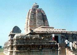 Sangameshwar temple at Alampur | |
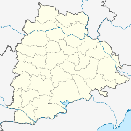 Alampur Location in Telangana, India  Alampur Alampur (India) | |
| Coordinates: 15.878°N 78.132°E | |
| Country | |
| State | Telangana |
| District | Jogulamba Gadwal |
| Elevation | 269 m (883 ft) |
| Population (2001) | |
| • Total | 9,350 |
| Languages | |
| • Official | Telugu |
| Time zone | UTC+5:30 (IST) |
| Vehicle registration | TS-06 |
| Website | telangana |
History
Alampur was under the rule of Shatavahana Ishvakus of Nagarjunakonda, Badami Chalukyas, Rashtrakutas, Kalyani Chalukyas, Kakatiyas, Vijayanagara Empire and Qutb Shahis of Golconda. Alampur was previously known as Halampuram, Hamalapuram And Alampuram. Under the name Hatampura, it was mentioned in the inscription dated AD 1101 and belongs to Western Chalukya Tribhuvanamalla Vikramaditya VI. Another inscription mentions construction of the temple by Vinayaditya Chalukya in 704 AD.
Temples
The Alampur Navabhrama Temples are historically important and reflect remarkable architectural skills. The Alampur temples are listed as an archaeological and architectural treasure on the official "List of Monuments" prepared by the Archaeological Survey of India under The Ancient Monuments and Archaeological Sites and Remains Act.[4] Since the original area of the temples at Alampur became submerged by the Sri Sailam Hydro-electric Project, the temples were relocated to higher ground. The uniqueness of this group of temples lies in their plan and design in the northern architectural style introduced by the Chalukyas of Badami between AD 650 and 750.[5]
The shrine of Jogulamba devi
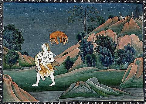
The Yogamba (Jogulamba) temple is regarded as a Shakti Peetha where Sati Devi's upper teeth fell.[6] The mythology of Daksha yaga and Sati's self immolation is the origin story of Shakti Peethas.[7] The original temple was grounded by Muslim invaders in 1390 A.D. The temple was rebuilt after 615 years.[8]
Shakti Peethas are shrines which are the most divine seats of the Mother Goddess. The body parts of the corpse of Sati Devi has fallen in these places, when Lord Shiva carried it and wandered throughout Aryavartha in sorrow. The 51 Shakti Peeth link to the 51 alphabets in Sanskrit.
Navabrahma Temples
Alampur Navabrahma Temples[9][10] include nine temples dedicated to Shiva.[6] These temples date back to the 7th century A.D and were built by the Badami Chalukyas rulers who were patrons of art and architecture.[11] The sacredness of Alampur Temple is mentioned in the Skanda Purana. It is mentioned that Brahma performed a strict penance here for Lord Siva. Lord Siva appeared before him and blessed him with the powers of creation. Therefore, the name Brahmeswara.[12]
Sangameshwara is derived from the word Sangam meaning confluence. Hence the temple is also known as Kudavelly Sangameshwara Temple. It is said that Sangameshwara Temple was constructed by Pulakesi I ( 540 CE to 566 CE) and is fine example of Chalukyan Architecture.
Demographics
The population in 1901 was 30,222, compared with the 27,271 in 1891. Alampur, the headquarters, had a population of 4,182.
As of 2001 India census,[13] Alampur had a population of 9350. Males constitute 54% of the population and females 46%. Alampur has an average literacy rate of 61%, higher than the national average of 59.5%; with 64% of the males and 36% of females literate. 16% of the population is under 6 years of age.
Geography
Krishna river separates the taluk from Mahbubnagar district on the North and the Tungabhadra from Karnataka state. The confluence of these two rivers is situated in the extreme east of the taluk, formerly at Kudavelly Village. The village was submerged by construction of Srisailam dam.
References
- "Alampur, Historical Places in Jugulamba Gadwal District". Archived from the original on 22 March 2009. Retrieved 25 March 2009.
- Map of Alampur Villages
- "Imperial Gazetteer2 of India, Volume 5". dsal.uchicago.edu. Digital South Asia Library. p. 204.
- "Alphabetical List of Monuments - Andhra Pradesh". Archaeological Survey of India. Archived from the original on 25 June 2014. Retrieved 27 August 2015.
- "Golconda Fort, Hyderabad" (PDF). Archived from the original (PDF) on 9 April 2009. Retrieved 15 April 2009.
- "Mahabubnagar-NIC". mahabubnagar.nic.in. Archived from the original on 3 April 2016. Retrieved 14 June 2016.
- "Kottiyoor Devaswam Temple Administration Portal". kottiyoordevaswom.com/. Kottiyoor Devaswam. Retrieved 20 July 2013.
- "Alampur Jogulamba Temple - Timings, History, Phone, Image, Websit". 22 April 2016.
- Chalukyan Temples of Andhradesa By B. R. Prasad. Retrieved 25 March 2009.
- "Alampur, Temples of Andhra Pradesh". Retrieved 25 March 2009.
- "Bewitching temple architecture". Archived from the original on 25 July 2008. Retrieved 26 March 2009.
- "Alampur Jogulamba Temple - Timings, History, Phone, Image, Websit". 22 April 2016.
- "Census of India 2001: Data from the 2001 Census, including cities, villages and towns (Provisional)". Census Commission of India. Archived from the original on 16 June 2004. Retrieved 1 November 2008.
External links
| Wikivoyage has a travel guide for Alampur (Telangana). |
| Wikimedia Commons has media related to Alampur, Andhra Pradesh. |
Hindu Temples in Telangana | ||
|---|---|---|
| Adilabad | 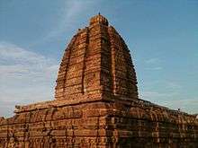 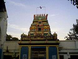 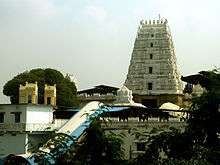 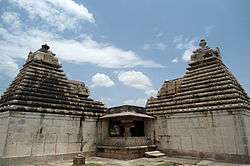 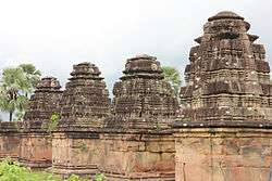 | |
| Hyderabad | ||
| Karimnagar | ||
| Khammam | ||
| Mahbubnagar | ||
| Medak |
| |
| Nalgonda |
| |
| Nizamabad | ||
| Rangareddy |
| |
| Warangal | ||
| Nirmal | ||
| Jagtial |
| |
| Jayashankar Bhupalpally | ||
| Rajanna Sircilla |
| |
| Bhadradri Kothagudem |
| |