Agugulu, American Samoa
Agugulu is a village on the southwest coast of Tutuila Island, American Samoa. It is located close to 'Amanave, not far from the island's western tip. It is located in Lealataua County.
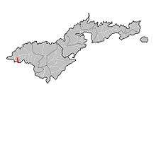
Map of Tutuila where Agugulu is marked in red.
Agugulu | |
|---|---|
Village | |
 Agugulu | |
| Coordinates: 14°20′8″S 170°49′18″W | |
| Country | |
| Territory | |
| County | Lealataua |
| Area | |
| • Land | 0.173 sq mi (0.449 km2) |
| Population (2010) | |
| • Total | 51[1] |
| • Density | 331.9/sq mi (128.1/km2) |
Demographics
| Population growth[2] | |
|---|---|
| 2010 | 51 |
| 2000 | 45 |
| 1990 | 42 |
| 1980 | 38 |
| 1970 | 44 |
| 1960 | 36 |
gollark: ++delete biology
gollark: That's more physics.
gollark: What is your pH, nobody?
gollark: Now, if *Factorio* has taught me anything, you don't even need to go underground, just hit some big green patches with a pickaxe.
gollark: Well, if MInecraft has taught me anything, you can find uranium ore at about y=11 and then smelt it with some coal in a furnace made from 8 cubic metres of stone.
References
- https://www.census.gov/population/www/cen2010/island_area/as.html
- "American Samoa Statistical Yearbook 2016" (PDF). American Samoa Department of Commerce. Archived from the original (PDF) on 2019-02-14. Retrieved 2019-07-25.
| Topics | |||||
|---|---|---|---|---|---|
| Geography | |||||
| Politics |
| ||||
| Economy |
| ||||
| Culture |
| ||||
| Districts |
| ||||
| Islands | |||||
| Villages |
| ||||
This article is issued from Wikipedia. The text is licensed under Creative Commons - Attribution - Sharealike. Additional terms may apply for the media files.