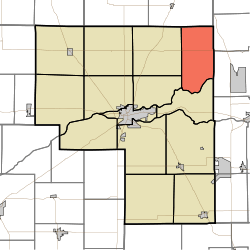
Adams Township, Cass County, Indiana
Adams Township is one of fourteen townships in Cass County, Indiana, United States. As of the 2010 census, its population was 895 and it contained 378 housing units.[2]
Adams Township | |
|---|---|
 Location of Adams Township in Cass County | |
| Coordinates: 40°50′54″N 86°12′57″W | |
| Country | United States |
| State | Indiana |
| County | Cass |
| Government | |
| • Type | Indiana township |
| Area | |
| • Total | 28.86 sq mi (74.7 km2) |
| • Land | 28.75 sq mi (74.5 km2) |
| • Water | 0.11 sq mi (0.3 km2) |
| Elevation | 787 ft (240 m) |
| Population (2010) | |
| • Total | 895 |
| • Density | 31.1/sq mi (12.0/km2) |
| Time zone | UTC-5 (Eastern (EST)) |
| • Summer (DST) | UTC-4 (EDT) |
| FIPS code | 18-00334[1] |
| GNIS feature ID | 0453075 |
History
Adams Township was organized in 1835. It was named for John Quincy Adams, sixth President of the United States.[3]
Geography
According to the 2010 census, the township has a total area of 28.86 square miles (74.7 km2), of which 28.75 square miles (74.5 km2) (or 99.62%) is land and 0.11 square miles (0.28 km2) (or 0.38%) is water.[2]
Unincorporated towns
- Hoover
- Little Charlie
- Twelve Mile
(This list is based on USGS data and may include former settlements.)
Adjacent townships
- Liberty Township, Fulton County (north)
- Union Township, Miami County (northeast)
- Jefferson Township, Miami County (east)
- Miami (south)
- Clay (southwest)
- Bethlehem (west)
Major highways
Cemeteries
The township contains one cemetery, Mount Carmel.
gollark: Testbot, take to finally vanquish the evil Tux1.
gollark: Hmm.
gollark: testbot, take an urgent appointment.
gollark: Or #æ.
gollark: Anyway, as Tux1 is wrong, he should go to #b.
References
- "Adams Township, Cass County, Indiana". Geographic Names Information System. United States Geological Survey. Retrieved 2009-09-24.
- United States Census Bureau cartographic boundary files
- "U.S. Census website". United States Census Bureau. Retrieved 2008-01-31.
- "Population, Housing Units, Area, and Density: 2010 - County -- County Subdivision and Place -- 2010 Census Summary File 1". United States Census. Archived from the original on 2020-02-12. Retrieved 2013-05-10.
- Helm, Thomas B. (1878). History of Cass County, Indiana. Kingman Bros. pp. 37.
This article is issued from Wikipedia. The text is licensed under Creative Commons - Attribution - Sharealike. Additional terms may apply for the media files.