2006 Borujerd earthquake
The 2006 Borujerd earthquake occurred in the early morning of 31 March in the South of Borujerd with destruction in Borujerd, Silakhor and Dorood areas of the Loristan Province in western Iran. The centre of the earthquake was in Darb-e Astaneh village south of the Borujerd City. The earthquake measured 6.1 on the moment magnitude scale.
 Tehran | |
| UTC time | 2006-03-31 01:17:00 |
|---|---|
| ISC event | 10614039 |
| USGS-ANSS | ComCat |
| Local date | March 31, 2006 |
| Local time | 04:47 |
| Magnitude | 6.1 Mw [1] |
| Depth | 10 km (6.2 mi) [1] |
| Epicenter | 33.56°N 48.73°E [1] |
| Type | Strike-slip [2] |
| Areas affected | Iran |
| Total damage | $42.262 million / moderate [2][3] |
| Max. intensity | VIII (Severe) [4] |
| Casualties | 63–70+ killed [4] 1,246–1,418 injured [4] |
Earthquake
This powerful earthquake shook the entire land of Loristan Province and most areas of Hamedan Province, Markazi Province and destroyed many villages in Khorramabad, Alashtar and Arak County as well. More than 180 aftershocks followed the main earthquake in April, May and June and people had to stay outside for several weeks.
A lighter foreshock happened the night before, and people stayed outside overnight and this reduced the number of casualties significantly. However, the mainshock at 4:47 am on 31 March shook Borujerd, Dorud and other towns and villages on Silakhor Plain for more than 55 seconds.
Damage
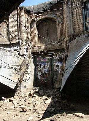
More than 40 major historical monuments of Borujerd were destroyed by the earthquake and 30% of the historical downtown of the city (2.7 kmª) was ruined or damaged thoroughly. Other monuments damaged by the earthquake include:
- Jame Mosque of Borujerd (900 AD)
- Soltani Mosque of Borujerd
- Imamzadeh Ja'far, Borujerd
- Chalenchoolan Bridge
- Ghaleh Hatam Bridge
- Birjandi Old House of Borujerd
- Mesri Old House of Borujerd
- Imamzadeh Khalogh Ali
- Tekyeh Movassaghi
- Pahlavei High School
Response
Apart from UN agencies e.g. UNESCO and UNICEF, there are other international agencies functioning in the field, including MSF, Caritas Italy, Operation Mercy, ACH Spain and ACT Netherlands.[5]
References
- ISC (2017), ISC-GEM Global Instrumental Earthquake Catalogue (1900–2013), Version 4.0, International Seismological Centre
- USGS (September 4, 2009), PAGER-CAT Earthquake Catalog, Version 2008_06.1, United States Geological Survey
- National Geophysical Data Center / World Data Service (NGDC/WDS) (1972), Significant Earthquake Database (Data Set), National Geophysical Data Center, NOAA, doi:10.7289/V5TD9V7K
- Berberian, M. (2014), Earthquakes and Coseismic Surface Faulting on the Iranian Plateau, Developments in Earth Surface Processes (1st ed.), Elsevier, p. 633, ISBN 978-0444632920
- ReliefWeb (10 Apr 2006). "Iran: Doroud Earthquake Information Bulletin no. 6". ReliefWeb.
External links
- Darb e Astaneh (Silakhor) Earthquake Report: March 31, 2006; ML=6.1 – IIEES
- IFRC- Iran Doroud Earthquake, Information Bulletin no.3 – IFRC
- M 6.1 - western Iran – USGS
- The International Seismological Centre has a bibliography and/or authoritative data for this event.
- ReliefWeb's main page for this event.