1974–75 South-West Indian Ocean cyclone season
The 1974–75 South-West Indian Ocean cyclone season was a below-average cyclone season. The season officially ran from November 1, 1974, to April 30, 1975.
| 1974–75 South-West Indian Ocean cyclone season | |
|---|---|
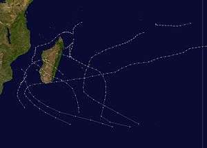 Season summary map | |
| Seasonal boundaries | |
| First system formed | 23 December 1974 |
| Last system dissipated | 22 April 1975 |
| Strongest storm | |
| Name | Gervaise |
| • Maximum winds | 120 km/h (75 mph) (10-minute sustained) |
| • Lowest pressure | 951 hPa (mbar) |
| Seasonal statistics | |
| Total disturbances | 10 |
| Total depressions | 8 |
| Total storms | 6 |
| Tropical cyclones | 2 |
| Total fatalities | 9 total |
| Total damage | Unknown |
| Related articles | |
Systems
Tropical Disturbance Adele
| Tropical disturbance (MFR) | |
| Tropical depression (SSHWS) | |
  | |
| Duration | December 23 – December 24 |
|---|---|
| Peak intensity | 55 km/h (35 mph) (1-min) |
Adele existed from December 23 to December 24.
Moderate Tropical Storm Blandine
| Moderate tropical storm (MFR) | |
| Tropical storm (SSHWS) | |
  | |
| Duration | January 6 – January 12 |
|---|---|
| Peak intensity | 75 km/h (45 mph) (1-min) 980 hPa (mbar) |
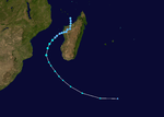
Blandine existed from January 6 to January 12.
Tropical Cyclone Camille
| Tropical cyclone (MFR) | |
| Category 1 tropical cyclone (SSHWS) | |
  | |
| Duration | January 10 – January 21 |
|---|---|
| Peak intensity | 140 km/h (85 mph) (1-min) 995 hPa (mbar) |
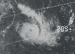
This system formed southeast of the Seychelles on January 7 before becoming disorganized while interacting with northern Madagascar. The system redeveloped as a hurricane-force cyclone in the northern Mozambique Channel on January 16 before moving southeast into Madagascar on January 19.[1]
Tropical Cyclone Robyn-Deborah
| Tropical cyclone (MFR) | |
| Category 1 tropical cyclone (SSHWS) | |
  | |
| Duration | January 14 – January 24 |
|---|---|
| Peak intensity | 140 km/h (85 mph) (1-min) 960 hPa (mbar) |
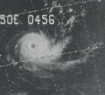
This system existed from January 14 to January 24.
Moderate Tropical Storm Elsa
| Moderate tropical storm (MFR) | |
| Tropical storm (SSHWS) | |
  | |
| Duration | January 25 – January 27 |
|---|---|
| Peak intensity | 65 km/h (40 mph) (1-min) |
Elsa existed from January 25 to January 27.
Tropical Disturbance Fernande
| Tropical disturbance (MFR) | |
| Tropical depression (SSHWS) | |
  | |
| Duration | February 1 – February 1 |
|---|---|
| Peak intensity | 55 km/h (35 mph) (1-min) |
This storm lasted for only 18 hours on February 1.
Tropical Cyclone Gervaise
| Tropical cyclone (MFR) | |
| Category 1 tropical cyclone (SSHWS) | |
  | |
| Duration | February 1 – February 10 |
|---|---|
| Peak intensity | 140 km/h (85 mph) (1-min) 951 hPa (mbar) |
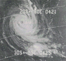
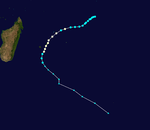
The origins of Cyclone Gervaise were in early February 1975 from a circular area of convection, or thunderstorms, located in the intertropical convergence zone southwest of Diego Garcia in the south-west Indian Ocean. The system organized as it moved generally to the southwest, a trajectory it would maintain for several days due to a subtropical ridge to its southeast, and an area of low pressure near the Mascarene Islands. On February 2, the Mauritius Meteorological Services[lower-alpha 1] named the storm Gervaise. Two days later, the storm attained hurricane status, or maximum sustained winds of at least 120 km/h (75 mph).[3] Late on February 5, Gervaise passed about 100 km (60 mi) southeast of St. Brandon. Continuing southwestward, the cyclone struck Mauritius on February 6, with the calm of the eye lasting for three hours. That day, the American-based Joint Typhoon Warning Center (JTWC)[lower-alpha 2] estimated peak winds of 130 km/h (85 mp).[4] On February 7, Gervaise passed about 130 km (80 mi) southeast of Réunion. The track shifted to the south and southeast over time, steered by a passing cold front. On February 10, Gervaise dissipated within the cold front.[3]
Gervaise first affected St. Brandon, producing wind gusts of over 100 km/h (62 mph), along with heavy rainfall. Cyclone Gervaise killed 10 people during its passage of Mauritius. Its strongest wind gusts occurred after the passage of the eye, peaking at 280 km/h (170 mph) at Mon Desert. Heavy rainfall affected the island for several days, reaching 674 mm (26.5 in) at Grosse Roche. The high winds knocked down power lines, radio transmission with Vacoas for 24 hours, and many crops. About 25% of the island's sugar cane crop was lost. The storm damaged several houses, leaving thousands homeless. The cyclone last affected Réunion, where it produced wind gusts of 180 km/h (110 mph). Gervaise also dropped heavy rainfall on the island, reaching 548 mm (21.6 in) at Plaine des Cafres.[3] It caused substantial damage to properties, vegetation and wildlife. Moored yachts around the coast were washed hundreds of yards inland in places due to the storm surge and in the Mauritian capital Port Louis, a cargo ship of ca. 10,000 tonnes was washed up on to the quay. 34 injured, 3,706 homeless.
Tropical Cyclone Helose
| Tropical cyclone (MFR) | |
| Tropical storm (SSHWS) | |
  | |
| Duration | February 19 – February 26 |
|---|---|
| Peak intensity | 65 km/h (40 mph) (1-min) 985 hPa (mbar) |
Helose existed from February 19 to February 26.
Moderate Tropical Storm Ines
| Moderate tropical storm (MFR) | |
| Tropical storm (SSHWS) | |
  | |
| Duration | March 9 – March 19 |
|---|---|
| Peak intensity | 100 km/h (65 mph) (1-min) 985 hPa (mbar) |
Ines existed from March 9 to March 19.
Moderate Tropical Storm Junon
| Moderate tropical storm (MFR) | |
| Tropical storm (SSHWS) | |
  | |
| Duration | April 18 – April 22 |
|---|---|
| Peak intensity | 65 km/h (40 mph) (1-min) |
Junon existed from April 18 to April 22.
See also
Notes
- Météo-France's meteorological office in Réunion (MFR) is the official Regional Specialized Meteorological Center for the South-West Indian Ocean, tracking all tropical cyclones from the east coast of Africa to 90° E. The Mauritius Meteorological Office is responsible for naming storms in the eastern east of 55° E.[2]
- The Joint Typhoon Warning Center (JTWC) is a joint United States Navy – United States Air Force task force that issues advisories for storms in the basin.
References
- Dick DeAngelis. "Hurricane Alley". Mariners Weather Log. 19 (3): 154.
- Philippe Caroff; et al. (April 2011). Operational procedures of TC satellite analysis at RSMC La Reunion (PDF) (Report). World Meteorological Organization. pp. 4–5. Retrieved 2013-10-27.
- Hurricane Gervaise, 1-9 February. National Climatic Data Center (Report). Global tropical/extratropical cyclone climatic atlas. 1996. Retrieved February 3, 2019.
- Kenneth R. Knapp; Michael C. Kruk; David H. Levinson; Howard J. Diamond; Charles J. Neumann (2010). 1975 20S:Gervaise (1975033S11073). The International Best Track Archive for Climate Stewardship (IBTrACS): Unifying tropical cyclone best track data (Report). Bulletin of the American Meteorological Society. Archived from the original on February 4, 2019. Retrieved February 3, 2019.