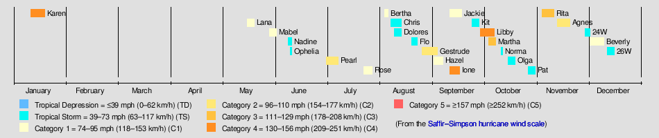
1948 Pacific typhoon season
The 1948 Pacific typhoon season is an event in the annual cycle of tropical cyclone formation, in which tropical cyclones form in the western Pacific Ocean. The season runs throughout 1948, though most tropical cyclones typically develop between May and October. The scope of this article is limited to the Pacific Ocean to the north of the equator between 100°E and 180th meridian. Within the northwestern Pacific Ocean, there are two separate agencies that assign names to tropical cyclones which can often result in a cyclone having two names. The Japan Meteorological Agency (JMA) will name a tropical cyclone should it be judged to have 10-minute sustained wind speeds of at least 65 km/h (40 mph) anywhere in the basin, whilst the Philippine Atmospheric, Geophysical and Astronomical Services Administration (PAGASA) assigns names to tropical cyclones which move into or form as a tropical depression in their area of responsibility located between 135°E and 115°E and between 5°N–25°N regardless of whether or not a tropical cyclone has already been given a name by the JMA. Tropical depressions that are monitored by the United States' Joint Typhoon Warning Center (JTWC) are given a number with a "W" suffix.
| 1948 Pacific typhoon season | |
|---|---|
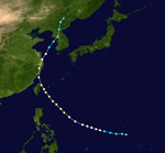
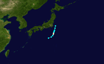
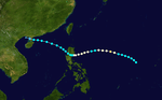
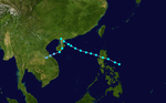
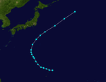
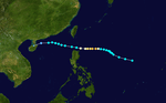
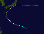
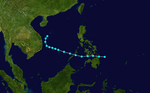
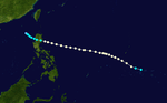
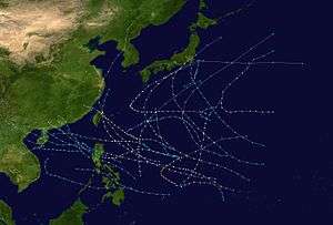 Season summary map | |
| Seasonal boundaries | |
| First system formed | January 11, 1948 |
| Last system dissipated | December 16, 1948 |
| Strongest storm | |
| Name | Libby |
| • Maximum winds | 230 km/h (145 mph) (1-minute sustained) |
| • Lowest pressure | 924 hPa (mbar) |
| Seasonal statistics | |
| Total storms | 26 |
| Typhoons | 15 |
| Super typhoons | 1 (unofficial) |
| Total fatalities | Unknown |
| Total damage | Unknown |
| Related articles | |
| |
Season summary
Storms
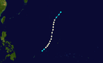
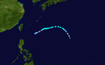
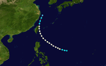
Typhoon Karen
| Typhoon (JMA) | |
| Category 4 super typhoon (SSHWS) | |
 | |
| Duration | January 11 – January 19 |
|---|---|
| Peak intensity | 240 km/h (150 mph) (1-min) 936 hPa (27.64 inHg) hPa (mbar) |
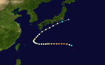
Typhoon Karen, the strongest cyclone of the season and the one of the earliest recorded if not the earliest super typhoon, developed on January 11, well west of the Philippines. It curved westward while slowly intensifying. After a prolonged period of the slow intensification, the tropical cyclone began to rapidly strengthen. It became a super typhoon on January 16. Shortly after, it weakened and dissipated on January 19.
Typhoon Lana
| Typhoon (JMA) | |
| Category 1 typhoon (SSHWS) | |
 | |
| Duration | May 16 – May 20 |
|---|---|
| Peak intensity | 150 km/h (90 mph) (1-min) 971 hPa (mbar) |
Typhoon Mabel
| Typhoon (JMA) | |
| Category 1 typhoon (SSHWS) | |
 | |
| Duration | May 29 – June 2 |
|---|---|
| Peak intensity | 150 km/h (90 mph) (1-min) 964 hPa (mbar) |
Typhoon Nadine
| Typhoon (JMA) | |
| Tropical storm (SSHWS) | |
 | |
| Duration | June 9 – June 11 |
|---|---|
| Peak intensity | 110 km/h (70 mph) (1-min) 986 hPa (mbar) |
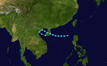
Tropical Storm Ophelia
| Tropical storm (SSHWS) | |
 | |
| Duration | June 10 – June 11 |
|---|---|
| Peak intensity | 75 km/h (45 mph) (1-min) 991 hPa (mbar) |
Ophelia formed on June 10 in the South China Sea. It moved west and struck southern China. It dissipated the next day, without attaining maximum sustained winds any higher than 45 mph.
Typhoon Pearl
| Typhoon (JMA) | |
| Category 2 typhoon (SSHWS) | |
 | |
| Duration | July 1 – July 8 |
|---|---|
| Peak intensity | 165 km/h (105 mph) (1-min) 960 hPa (mbar) |
Typhoon Rose
| Typhoon (JMA) | |
| Category 1 typhoon (SSHWS) | |
 | |
| Duration | July 23 – July 28 |
|---|---|
| Peak intensity | 130 km/h (80 mph) (1-min) 981 hPa (mbar) |
Typhoon Bertha
| Typhoon (JMA) | |
| Category 1 typhoon (SSHWS) | |
 | |
| Duration | August 4 – August 6 |
|---|---|
| Peak intensity | 130 km/h (80 mph) (1-min) 976 hPa (mbar) |
Typhoon Chris
| Typhoon (JMA) | |
| Tropical storm (SSHWS) | |
 | |
| Duration | August 8 – August 14 |
|---|---|
| Peak intensity | 95 km/h (60 mph) (1-min) 988 hPa (mbar) |
Typhoon Dolores–Eunice
| Typhoon (JMA) | |
| Tropical storm (SSHWS) | |
 | |
| Duration | August 10 – August 14 |
|---|---|
| Peak intensity | 85 km/h (50 mph) (1-min) 990 hPa (mbar) |
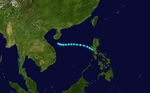
Tropical Storm Dolores was tracked by the Air Weather Service located on Guam. At one point, a tropical storm was identified and assigned the name Eunice. Post analysis showed that Tropical Storm Dolores was north of the forecast location and actually the system assigned the name Eunice.[1]
Typhoon Flo
| Typhoon (JMA) | |
| Tropical storm (SSHWS) | |
 | |
| Duration | August 20 – August 23 |
|---|---|
| Peak intensity | 95 km/h (60 mph) (1-min) 990 hPa (mbar) |
Typhoon Gestrude
| Typhoon (JMA) | |
| Category 2 typhoon (SSHWS) | |
 | |
| Duration | August 27 – September 4 |
|---|---|
| Peak intensity | 155 km/h (100 mph) (1-min) 976 hPa (mbar) |
Typhoon Hazel
| Typhoon (JMA) | |
| Category 1 typhoon (SSHWS) | |
 | |
| Duration | September 2 – September 7 |
|---|---|
| Peak intensity | 150 km/h (90 mph) (1-min) 966 hPa (mbar) |
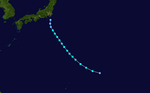
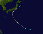
Typhoon Ione
| Typhoon (JMA) | |
| Category 4 typhoon (SSHWS) | |
 | |
| Duration | September 11 – September 17 |
|---|---|
| Peak intensity | 220 km/h (140 mph) (1-min) 925 hPa (mbar) |
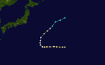
A Tropical Storm formed on September 11 and soon turned toward Japan as it gained strength. Ione soon reached category 4 intensity on September 14. Ione then began to lose strength and became a category 1 on September 16. Then, Ione struck Japan in that day killing 838 people.[2] Ione further weakened and became a Tropical Storm on the 17th. Ione then dissipated.
Typhoon Jackie
| Typhoon (JMA) | |
| Category 1 typhoon (SSHWS) | |
 | |
| Duration | September 11 – September 18 |
|---|---|
| Peak intensity | 150 km/h (90 mph) (1-min) 962 hPa (mbar) |
Typhoon Kit
| Typhoon (JMA) | |
| Tropical storm (SSHWS) | |
 | |
| Duration | September 24 – September 28 |
|---|---|
| Peak intensity | 110 km/h (70 mph) (1-min) 989 hPa (mbar) |
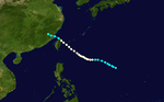
Typhoon Libby
| Typhoon (JMA) | |
| Category 4 typhoon (SSHWS) | |
 | |
| Duration | September 29 – October 7 |
|---|---|
| Peak intensity | 230 km/h (145 mph) (1-min) 924 hPa (mbar) |
Typhoon Martha
| Typhoon (JMA) | |
| Category 3 typhoon (SSHWS) | |
 | |
| Duration | October 4 – October 8 |
|---|---|
| Peak intensity | 185 km/h (115 mph) (1-min) 943 hPa (mbar) |
Typhoon Norma
| Typhoon (JMA) | |
| Tropical storm (SSHWS) | |
 | |
| Duration | October 11 – October 12 |
|---|---|
| Peak intensity | 95 km/h (60 mph) (1-min) 992 hPa (mbar) |
Tropical Storm Olga
| Tropical storm (SSHWS) | |
 | |
| Duration | October 16 – October 19 |
|---|---|
| Peak intensity | 100 km/h (65 mph) (1-min) 994 hPa (mbar) |
Typhoon Pat
| Typhoon (JMA) | |
| Tropical storm (SSHWS) | |
 | |
| Duration | October 27 – October 31 |
|---|---|
| Peak intensity | 110 km/h (70 mph) (1-min) 987 hPa (mbar) |
Typhoon Rita
| Typhoon (JMA) | |
| Category 3 typhoon (SSHWS) | |
 | |
| Duration | November 4 – November 11 |
|---|---|
| Peak intensity | 185 km/h (115 mph) (1-min) 957 hPa (mbar) |
Typhoon Agnes
| Typhoon (JMA) | |
| Category 2 typhoon (SSHWS) | |
 | |
| Duration | November 13 – November 20 |
|---|---|
| Peak intensity | 175 km/h (110 mph) (1-min) 939 hPa (mbar) |
Tropical Storm 24W
| Tropical storm (SSHWS) | |
 | |
| Duration | November 29 – December 2 |
|---|---|
| Peak intensity | 85 km/h (50 mph) (1-min) 997 hPa (mbar) |
Typhoon Beverly
| Typhoon (JMA) | |
| Category 1 typhoon (SSHWS) | |
 | |
| Duration | December 2 – December 10 |
|---|---|
| Peak intensity | 150 km/h (90 mph) (1-min) 947 hPa (mbar) |
Tropical Storm 26W
| Tropical storm (SSHWS) | |
 | |
| Duration | December 12 – December 16 |
|---|---|
| Peak intensity | 75 km/h (45 mph) (1-min) 997 hPa (mbar) |
Other Systems
Between 23 July and 4 August, the name Annabell was assigned to a North West Pacific system. The Air Weather Service issued a bulletin issued and tropical cyclone named on what was later determined to be "trough activity"
Storm names
Tropical storm names were assigned by the Joint Typhoon Warning Center since 1945.
| Karen | Lana | Mabel | Nadine | Ophelia | Pearl | Rose | Annabell | Bertha |
| Chris | Dolores | Eunice | Flo | Gestrude | Hazel | Ione | Jackie | Kit |
| Libby | Martha | Norma | Olga | Pat | Rita | Agnes | Beverly |
See also
- 1948 Atlantic hurricane season
- List of Pacific typhoon seasons
References
- Air Weather Service "Report on the Typhoon Post-Analysis Program (1948-1949) of the North Pacific Typhoon Warning System"
- Translate.google.com
External links
- Unisys season tracks
- List of DOD publishing organizations and basins covered for the entire 1945-2000 period.