1945 Pacific typhoon season
The 1945 Pacific typhoon season was the first official season to be included in the West Pacific typhoon database. It has no official bounds; it ran year-round in 1945, but most tropical cyclones tend to form in the northwestern Pacific Ocean between June and December. These dates conventionally delimit the period of each year when most tropical cyclones form in the northwestern Pacific Ocean.
| 1945 Pacific typhoon season | |
|---|---|
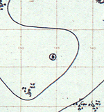
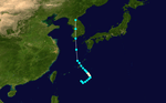
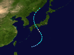
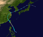
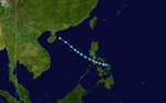
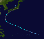
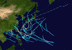 Season summary map | |
| Seasonal boundaries | |
| First system formed | April 19, 1945 |
| Last system dissipated | December 2, 1945 |
| Strongest storm | |
| Name | Ida |
| • Lowest pressure | 916 hPa (mbar) |
| Seasonal statistics | |
| Total storms | 26 |
| Typhoons | 13 |
| Super typhoons | 0 (unofficial) |
| Total fatalities | 3,798+ |
| Total damage | Unknown |
| Related articles | |
| |
The scope of this article is limited to the Pacific Ocean, north of the equator and west of the international date line. Storms that form east of the date line and north of the equator are called hurricanes; see 1945 Pacific hurricane season. Tropical Storms formed in the entire west pacific basin were assigned a name by the Joint Typhoon Warning Center. Tropical depressions in this basin have the "W" suffix added to their number. Tropical depressions that enter or form in the Philippine area of responsibility are assigned a name by the Philippine Atmospheric, Geophysical and Astronomical Services Administration or PAGASA. This can often result in the same storm having two names.
Systems
Tropical Storm Ann
| Tropical storm (SSHWS) | |
 | |
| Duration | April 19 – April 26 |
|---|---|
| Peak intensity | 95 km/h (60 mph) (1-min) 995 hPa (mbar) |
Tropical Storm Ann was the first storm of the 1945 Pacific typhoon season and was formed on April 19. The storm made no landfall. It dissipated on April 26.
Tropical Storm Betty
| Tropical storm (SSHWS) | |
 | |
| Duration | May 13 – May 16 |
|---|---|
| Peak intensity | 100 km/h (65 mph) (1-min) 994 hPa (mbar) |
Tropical Storm Betty formed on May 13, 1945, and began to move in a northeastern direction. It strengthened into a tropical storm only 18 hours later, and continued on its path. However, the storm eventually moved further north, and into colder waters. Betty weakened into a tropical depression and dissipated on May 16th, having not threatened land at all.
Typhoon Connie
| Category 1 typhoon (SSHWS) | |
  | |
| Duration | June 1 – June 7 |
|---|---|
| Peak intensity | 130 km/h (80 mph) (1-min) 980 hPa (mbar) |
A small, yet powerful typhoon, Connie, was first spotted on June 1 by the Weather Central Guam, moving northeast. Winds were reported to have been as high as 140 mph. But by June 7, it began to weaken. Its final fate is unknown. The U.S. Navy's Third Fleet was hit by Connie. The same fleet had previously been hit, with great loss of life, by Typhoon Cobra, in 1944. Connie being lesser, only one officer and five USN men were lost or killed because of Connie, and around 150 airplanes on its carriers were either lost or damaged.
Tropical Storm Doris
| Tropical storm (SSHWS) | |
  | |
| Duration | June 18 – June 21 |
|---|---|
| Peak intensity | 85 km/h (50 mph) (1-min) 997 hPa (mbar) |
Tropical Storm Doris existed from June 18 to June 21 and did not make landfall.
Tropical Storm Nancy
| Tropical storm (SSHWS) | |
  | |
| Duration | July 3 – July 8 |
|---|---|
| Peak intensity | 95 km/h (60 mph) (1-min) 992 hPa (mbar) |
Typhoon Opal
| Category 1 typhoon (SSHWS) | |
  | |
| Duration | July 14 – July 22 |
|---|---|
| Peak intensity | 120 km/h (75 mph) (1-min) 986 hPa (mbar) |
Tropical Storm Peggy
| Tropical storm (SSHWS) | |
  | |
| Duration | July 22 – July 23 |
|---|---|
| Peak intensity | 65 km/h (40 mph) (1-min) 998 hPa (mbar) |
Tropical Storm Edna
| Tropical storm (SSHWS) | |
 | |
| Duration | July 27 – July 29 |
|---|---|
| Peak intensity | 75 km/h (45 mph) (1-min) 995 hPa (mbar) |
Typhoon Eva
| Category 1 typhoon (SSHWS) | |
 | |
| Duration | July 30 – August 4 |
|---|---|
| Peak intensity | 150 km/h (90 mph) (1-min) 978 hPa (mbar) |
Typhoon Queenie
| Category 1 typhoon (SSHWS) | |
 | |
| Duration | August 5 – August 9 |
|---|---|
| Peak intensity | 150 km/h (90 mph) (1-min) 978 hPa (mbar) |
Tropical Storm Frances
| Tropical storm (SSHWS) | |
 | |
| Duration | August 9 – August 13 |
|---|---|
| Peak intensity | 95 km/h (60 mph) (1-min) 992 hPa (mbar) |
Tropical Storm Grace
| Tropical storm (SSHWS) | |
 | |
| Duration | August 15 – August 22 |
|---|---|
| Peak intensity | 110 km/h (70 mph) (1-min) 985 hPa (mbar) |
Typhoon Ruth
| Category 1 typhoon (SSHWS) | |
 | |
| Duration | August 22 – August 28 |
|---|---|
| Peak intensity | 130 km/h (80 mph) (1-min) 978 hPa (mbar) |
Typhoon Susan
| Category 1 typhoon (SSHWS) | |
 | |
| Duration | August 23 – August 28 |
|---|---|
| Peak intensity | 150 km/h (90 mph) (1-min) 968 hPa (mbar) |
Typhoon Tess
| Category 1 typhoon (SSHWS) | |
 | |
| Duration | August 23 – August 25 |
|---|---|
| Peak intensity | 130 km/h (80 mph) (1-min) 980 hPa (mbar) |
Typhoon Helen
| Category 3 typhoon (SSHWS) | |
 | |
| Duration | August 29 – September 4 |
|---|---|
| Peak intensity | 195 km/h (120 mph) (1-min) 965 hPa (mbar) |
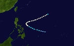
Typhoon Helen formed on August 29. It moved west-northwest and strengthened into a category 3 typhoon with 120 mph winds. It weakened slightly to a category two and struck Taiwan. It briefly was over waters before it hit Mainland China as a tropical storm. It dissipated on September 4.
Typhoon Ursula
| Category 2 typhoon (SSHWS) | |
 | |
| Duration | September 7 – September 15 |
|---|---|
| Peak intensity | 165 km/h (105 mph) (1-min) 968 hPa (mbar) |
This typhoon is especially remembered for the 6 aircraft containing liberated prisoners of war brought down by the typhoon between Okinawa and Manila. Over 120 servicemen lost their lives. At the time, it was the single greatest loss of life in an aviation disaster during peacetime.[1]
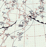
Typhoon Ida
| Category 1 typhoon (SSHWS) | |
  | |
| Duration | September 10 – September 20 |
|---|---|
| Peak intensity | 130 km/h (80 mph) (1-min) 916.1 (lowest observed over land) hPa (mbar) |
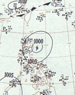
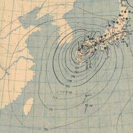
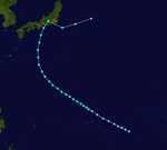
In Japan, Typhoon Ida is called Makurazaki Typhoon. It was the strongest typhoon to hit Kyushu on record, with a minimum sea-level pressure of 916.1 hPa (27.05 inHg) and a maximum wind gust of 62.7 metres per second (140 mph), which was recorded at a weather station in Makurazaki.[2] More than 2,000 people were killed in the Hiroshima Prefecture after heavy rains brought by a weakening Ida caused severe landslides.[3]
Tropical Storm Verna
| Tropical storm (SSHWS) | |
 | |
| Duration | September 20 – September 22 |
|---|---|
| Peak intensity | 95 km/h (60 mph) (1-min) 988 hPa (mbar) |
Tropical Storm Wanda
| Tropical storm (SSHWS) | |
 | |
| Duration | September 21 – September 24 |
|---|---|
| Peak intensity | 75 km/h (45 mph) (1-min) 998 hPa (mbar) |
Typhoon Jean
| Category 2 typhoon (SSHWS) | |
 | |
| Duration | September 25 – October 2 |
|---|---|
| Peak intensity | 165 km/h (105 mph) (1-min) 963 hPa (mbar) |
Tropical Storm Kate
| Tropical storm (SSHWS) | |
 | |
| Duration | September 28 – October 6 |
|---|---|
| Peak intensity | 110 km/h (70 mph) (1-min) 980 hPa (mbar) |
Typhoon Louise
| Category 1 typhoon (SSHWS) | |
  | |
| Duration | October 2 – October 12 |
|---|---|
| Peak intensity | 150 km/h (90 mph) (1-min) 969 hPa (mbar) |
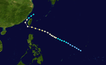
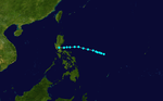
Louise was first seen developing on October 2, 1945, in the Caroline Islands. It unexpectedly veered north and slowed down, only to intensify as it passed over Okinawa on October 9 with 90 mph wind gusts and a minimum central pressure of 968.5 mbar. Shortly after, Louise began to weaken, and hit Japan as a strong tropical storm. The tropical cyclone became extratropical shortly after on October 12. In Okinawa, 36 people died, 47 people were reported missing, and 100 people were seriously injured.
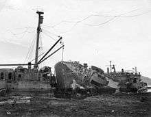
In Buckner Bay, where the US military were occupying a temporary base, 30 ft (9.1 m) to 35 ft (11 m) waves were reported to have crashed ashore, tearing into Quonset huts and other buildings. At the time, Buckner Bay was being used as a port by the US military. Fifteen merchant ships were driven ashore, with a few wrecked. Three US Navy destroyers were grounded and declared beyond salvage. Over 200 other US military vessels, including six LSTs, a number of special purpose boats, patrol boats, and amphibious landing craft were grounded, severely damaged, or wrecked beyond repair. Eighty percent of the buildings in the bay were completely wiped out, while all 60 airplanes at the local airports were damaged.[4]
Tropical Storm Marge
| Tropical storm (SSHWS) | |
 | |
| Duration | November 1 – November 4 |
|---|---|
| Peak intensity | 85 km/h (50 mph) (1-min) 996 hPa (mbar) |
Tropical Storm Yvonne
| Tropical storm (SSHWS) | |
 | |
| Duration | November 14 – November 17 |
|---|---|
| Peak intensity | 75 km/h (45 mph) (1-min) 999 hPa (mbar) |
Typhoon Nora
| Category 1 typhoon (SSHWS) | |
 | |
| Duration | November 22 – December 2 |
|---|---|
| Peak intensity | 150 km/h (90 mph) (1-min) 971 hPa (mbar) |
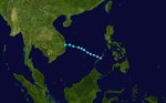
Typhoon Nora formed on November 22nd, 1945, and began to move towards the Philippines. It became a typhoon and a category 1 equivalent storm on the SSHWS scale. The slow-moving storm moved towards the Philippines, but it turned northeast at the last moment, moving over colder waters and dissipating.
Storm names
|
|
|
See also
- 1945 Atlantic hurricane season
- List of Pacific typhoon seasons
References
- https://noaahrd.wordpress.com/2015/09/09/70th-anniversary-of-typhoon-ursula/amp/
- Weather Records of Makurazaki Japan Meteorological Agency
- Makurazaki typhoon Hiroshima disaster prevention Web Archived 2017-07-14 at the Wayback Machine Hiroshima Prefectural Government
- US Navy Historical Center. Pacific Typhoon at Okinawa, October 1945.