171st meridian east
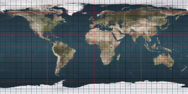
The meridian 171° east of Greenwich is a line of longitude that extends from the North Pole across the Arctic Ocean, Asia, the Pacific Ocean, New Zealand, the Southern Ocean, and Antarctica to the South Pole.
.svg.png)
171°
171st meridian east
The 171st meridian east forms a great circle with the 9th meridian west.
From Pole to Pole
Starting at the North Pole and heading south to the South Pole, the 171st meridian east passes through:
Co-ordinates Country, territory or sea Notes 90°0′N 171°0′E Arctic Ocean 73°41′N 171°0′E East Siberian Sea 70°5′N 171°0′E 
Chukotka Autonomous Okrug
Kamchatka Krai — from 62°17′N 171°0′E60°31′N 171°0′E Bering Sea 53°30′N 171°0′E Pacific Ocean Passing just east of the island of Mejit, 
8°53′N 171°0′E Maloelap Atoll 8°39′N 171°0′E Pacific Ocean Passing just west of Aur Atoll,
Passing just west of Majuro Atoll,42°41′S 171°0′E 
South Island — passing just east of the town of Oamaru (at 45°4′N 170°58′E) 45°5′S 171°0′E Pacific Ocean 60°0′S 171°0′E Southern Ocean 77°20′S 171°0′E Antarctica Ross Dependency, claimed by
gollark: Did you add the hard disk wiping command?
gollark: Madness.
gollark: I'm going to name my language QERTYUIOPWASDFGHJLZXCVBKNM.
gollark: Loostack, Funstack?
gollark: Yes, that.
See also
 |
This article is issued from Wikipedia. The text is licensed under Creative Commons - Attribution - Sharealike. Additional terms may apply for the media files.