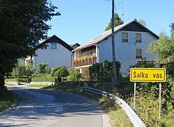
Šalka Vas
Šalka Vas (pronounced [ˈʃaːu̯ka ˈʋaːs]; Slovene: Šalka vas, German: Schalkendorf[2][3]) is a settlement immediately northeast of the town of Kočevje in southern Slovenia. The area is part of the traditional region of Lower Carniola and is now included in the Southeast Slovenia Statistical Region.[4]
Šalka Vas | |
|---|---|
 | |
 Šalka Vas Location in Slovenia | |
| Coordinates: 45°39′9.08″N 14°52′44.36″E | |
| Country | |
| Traditional region | Lower Carniola |
| Statistical region | Southeast Slovenia |
| Municipality | Kočevje |
| Area | |
| • Total | 1.66 km2 (0.64 sq mi) |
| Elevation | 479.2 m (1,572.2 ft) |
| Population (2002) | |
| • Total | 674 |
| [1] | |
History
The Šalka Vas volunteer fire department became a founding unit of the Kočevje municipal fire department on 28 August 1955.[5]
Church
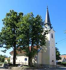
Saint Roch's Church
The local church is dedicated to Saint Roch and belongs to the Parish of Kočevje. It is a Late Gothic building that was extended in the 19th century.[6]
gollark: That's not my name.
gollark: Life finds a way.
gollark: Ah yes, my pack is outdated.
gollark: I should still have the light remote on my neural interfafce.
gollark: I think I might have had a keycard last year. Maybe it's in storage somewhere.
References
- Statistical Office of the Republic of Slovenia
- Leksikon občin kraljestev in dežel zastopanih v državnem zboru, vol. 6: Kranjsko. 1906. Vienna: C. Kr. Dvorna in Državna Tiskarna, p. 40.
- Ferenc, Mitja. 2007. Nekdanji nemški jezikovni otok na kočevskem. Kočevje: Pokrajinski muzej, p. 4.
- Kočevje municipal site
- Gasilska zveza Kočevja: Zgodovina (in Slovene)
- Slovenian Ministry of Culture register of national heritage reference number ešd 1889
External links
- Šalka Vas on Geopedia
- Pre–World War II map of Šalka Vas with oeconyms and family names


This article is issued from Wikipedia. The text is licensed under Creative Commons - Attribution - Sharealike. Additional terms may apply for the media files.