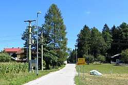
Breg pri Kočevju
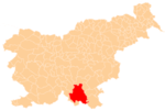
Breg pri Kočevju (pronounced [ˈbɾeːk pɾi kɔˈtʃeːu̯ju]; German: Rain[2][3]) is a settlement on the left bank of the Rinža River north of Kočevje in southern Slovenia. The area is part of the traditional region of Lower Carniola and is now included in the Southeast Slovenia Statistical Region.[4]
Breg pri Kočevju | |
|---|---|
 | |
 Breg pri Kočevju Location in Slovenia | |
| Coordinates: 45°39′28.98″N 14°50′14.65″E | |
| Country | |
| Traditional region | Lower Carniola |
| Statistical region | Southeast Slovenia |
| Municipality | Kočevje |
| Area | |
| • Total | 0.82 km2 (0.32 sq mi) |
| Elevation | 465.7 m (1,527.9 ft) |
| Population (2002) | |
| • Total | 336 |
| [1] | |
Name
The name of the settlement was changed from Breg to Breg pri Kočevju in 1953.[5]
gollark: <@738361430763372703> I could run an osmarksßstelemetry™ server but our HSTS policy is VERY strict so it would have to be HTTPS.
gollark: Guess we'll have to somehow fix popular views of those things if that is the case!
gollark: Wasn't that one kind of terrible? Tiny sample size and an actively involved experimenter?
gollark: Milgram obedience experiments?
gollark: So just use 6 important people.
References
- Statistical Office of the Republic of Slovenia
- Leksikon občin kraljestev in dežel zastopanih v državnem zboru, vol. 6: Kranjsko. 1906. Vienna: C. Kr. Dvorna in Državna Tiskarna, p. 42.
- Ferenc, Mitja. 2007. Nekdanji nemški jezikovni otok na kočevskem. Kočevje: Pokrajinski muzej, p. 4.
- Kočevje municipal site
- Spremembe naselij 1948–95. 1996. Database. Ljubljana: Geografski inštitut ZRC SAZU, DZS.
External links
- Breg pri Kočevju on Geopedia
- Pre–World War II map of Breg pri Kočevju with oeconyms and family names

This article is issued from Wikipedia. The text is licensed under Creative Commons - Attribution - Sharealike. Additional terms may apply for the media files.