Wisconsin Highway 26
State Trunk Highway 26 (often called Highway 26, STH 26, or WIS 26) is a state highway in the U.S. state of Wisconsin. The route is partially a divided highway with a few freeway bypass sections for roughly 50 miles. The remaining sections of WIS 26 is a two-lane road. WIS 26 provides direct access from Janesville to Oshkosh via Fort Atkinson, Watertown, and Waupun.
| ||||
|---|---|---|---|---|
 | ||||
| Route information | ||||
| Maintained by WisDOT | ||||
| Length | 98.15 mi[1] (157.96 km) | |||
| Major junctions | ||||
| South end | ||||
| North end | ||||
| Location | ||||
| Counties | Rock, Jefferson, Dodge, Fond du Lac, Winnebago | |||
| Highway system | ||||
| ||||

Route description
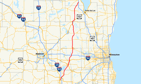
WIS 26 begins in downtown Janesville, Rock County at US 51 (North Parker Drive), and follows East Centerway Street, to turn northeast on Milton Ave.[2] WIS 26 crosses US 14 and I-39 / I-90 on the northeast side of the city. WIS 26 is a divided highway with a few freeway bypass sections from Janesville to WIS 60 for about 50 miles. WIS 26 goes 5 miles north of the I-39/I-90 before bypassing Milton to the east. WIS 59 crosses WIS 26 in Milton. WIS 26 crosses over to Jefferson County about five miles (8 km) north of Milton.[3] The highway turns northeast at the county line and approaches Fort Atkinson, but turns northwestward prior to entering the city, and bypasses it to the west with 4 exits to serve Fort Atkinson. Direct access is provided to WIS 106 and US 12. WIS 89 crosses the route, but no direct access is provided. WIS 26 then continues north for 2 miles (6 km) to Jefferson, where WIS 26 bypass the city to the west. It has 3 exits serving Jefferson including one at US 18. The highway passes through Johnson Creek at the interchange with I-94. About 4 miles north of I-94, WIS 26 bypasses Watertown to the west as the highway crosses into Dodge County.[4] The bypass has 3 exits serving Watertown including at WIS 19 and WIS 16.
On the Dodge County side of Watertown, WIS 26 and WIS 16 run a concurrency for 8 miles (13 km) to near Clyman where WIS 16 exits at WIS 60. WIS 26 goes into Juneau then crosses WIS 33 three miles (5 km) north of Juneau. After eleven more miles, WIS 26 crosses US 151 and passes through Waupun. WIS 26 joins US 151 crosses into Fond du Lac County at its junction with WIS 49 in Waupun.[5] WIS 26 joins US 151 for one mile (1.6 km) then turns north off the US route. After ten miles (16 km), the highway crosses WIS 23 in Rosendale. The highway then angles northeastward over the remaining seven miles (11 km) before entering Winnebago County[6] Four more miles into the county the route terminates at its interchange with Interstate 41/US 41 on the far southwest side of Oshkosh, about two miles (3 km) south of the Wittman Regional Airport, site of EAA AirVenture Oshkosh.[7]
History
The original 1917 alignment of WIS 26 mostly followed the current alignment south of Juneau, but the segment north of Juneau was directed towards Theresa. 1921 saw WIS 26 extended via Kewaskum and Waldo to end at Sheboygan - via present-day Wisconsin Highway 28.[8] In 1924, the route was realigned. From Juneau, it followed its present alignment to US 41 and into Oshkosh, then continued north from that point along present day WIS 76 up to Greenville, turning westward onto present-day WIS 15 there to continue to New London.[9] From there, the route followed present-day US 45, passing through Clintonville, Wittenberg, Antigo and Eagle River. The route connected with then M-26.[10] WIS 26 was also concurrent with WIS 10 south of Janesville. 1934 saw the debut of US 45, which replaced WIS 26 from Oshkosh northward. The route was truncated on the southern end to end at Janesville in the late 1940s.[1]
Four bypasses were constructed for WIS 26 - around Milton to the east in 2013-14, around Fort Atkinson to the west in the 1990s, around Jefferson to the west in the 2000s, and around Watertown to the west in 2012-14.[1]
Major intersections
| County | Location | mi | km | Exit | Destinations | Notes |
|---|---|---|---|---|---|---|
| Rock | Janesville | 0.0 | 0.0 | |||
| 2.9 | 4.7 | |||||
| 3.3 | 5.3 | Exit 171A on I-39/90 | ||||
| Milton | 3.3 | 5.3 | 6 | Harmony Town Hall Road | ||
| 8.1 | 13.0 | 8 | ||||
| 11.9 | 19.2 | 11 | ||||
| Jefferson | Fort Atkinson | 17.4 | 28.0 | 17 | ||
| 19.5 | 31.4 | 19 | ||||
| 21.3 | 34.3 | 21 | ||||
| 23.4 | 37.7 | 23 | ||||
| Jefferson | 25.1 | 40.4 | 25 | |||
| 27.3 | 43.9 | 27 | ||||
| 30.0 | 48.3 | 30 | ||||
| Johnson Creek | 34.4 | 55.4 | At-grade intersection; Exit 267 on I-94 | |||
| Watertown | 39.5 | 63.6 | 39 | |||
| 43.1 | 69.4 | 43 | ||||
| Dodge | 45.0 | 72.4 | 45 | Southern end of WI-16 concurrency | ||
| Clyman | 52.8 | 85.0 | 52 | Northern end of WI-16 concurrency | ||
| Juneau | 62.7 | 100.9 | ||||
| Waupun | 73.2 | 117.8 | ||||
| 75.3 | 121.2 | |||||
| Fond du Lac | 76.8 | 123.6 | 147 | Southbound exit and northbound entrance; southern end of US 151 concurrency; exit numbers follow US-151 mileage | ||
| 78.1 | 125.7 | 148 | Northern end of US-151 concurrency | |||
| Rosendale | 88.6 | 142.6 | ||||
| Winnebago | Oshkosh | 99.8 | 160.6 | Northern terminus; Exit 113 on I-41 | ||
1.000 mi = 1.609 km; 1.000 km = 0.621 mi
| ||||||
Special routes
Fort Atkinson business loop
| |
|---|---|
| Location | Fort Atkinson |
| Length | 5.78 mi (9.30 km) |
Business WIS 26 in Fort Atkinson starts at WIS 26 Exit 17 and follows Janesville Ave., Robert St., Madison Ave., North 3rd St., and N. High St. before ending at WIS 26 Exit 23.
Jefferson business loop
| |
|---|---|
| Location | Jefferson |
| Length | 4.4 mi (7.1 km) |
Business WIS 26 in Jefferson starts at WIS 26 Exit 25 and follows the old routing of WIS 26 along Main St before ending at WIS 26 Exit 30.
Watertown business loop
| |
|---|---|
| Location | Watertown |
| Length | 5.4 mi (8.7 km) |
Business WIS 26 in Watertown starts at WIS 26 Exit 39 and follows the old routing of WIS 26 along Church St. to Wisconsin 16. It then turns west with WIS 16 for a short distance before ending at WIS 26 Exit 45. Old WIS 26 north of WIS 16 is now County Hwy L.
References
| Wikimedia Commons has media related to Wisconsin Highway 26. |
- Bessert, Chris. "Wisconsin Highways: Highways 20-29 (Highway 26)". Wisconsin Highways. Retrieved 2007-03-20.
- Google (2008-01-10). "Janesville, WI, United States of America" (Map). Google Maps. Google. Retrieved 2008-01-10.
- Rock Co (pdf) (Map). Wisconsin Department of Transportation. Retrieved 2008-01-15.
- Jefferson Co (pdf) (Map). Wisconsin Department of Transportation. Retrieved 2008-01-15.
- Dodge Co (pdf) (Map). Wisconsin Department of Transportation. Retrieved 2008-01-15.
- Fond du Lac Co (pdf) (Map). Wisconsin Department of Transportation. Retrieved 2008-01-15.
- Winnebago Co (pdf) (Map). Wisconsin Department of Transportation. Retrieved 2008-01-15.
- "Original State Trunk Highway System in Wisconsin". Southeast Wisconsin Regional Planning Commission. 1918. Retrieved 2008-01-10.
- "Rand McNally Auto Road Atlas". Rand McNally. 1926. Retrieved 2007-01-10.
- "Rand McNally Auto Road Atlas". Rand McNally. 1926. Retrieved 2007-01-10.