Wisconsin Highway 33
State Trunk Highway 33 (often called Highway 33, STH 33 or WIS 33) is a Wisconsin state highway running east–west across central Wisconsin. It is 200.84 miles (323.22 km) in length.
| ||||
|---|---|---|---|---|
| 84th Division “Railsplitters” Memorial Highway | ||||
| Route information | ||||
| Maintained by WisDOT | ||||
| Length | 200.84 mi[1] (323.22 km) | |||
| Major junctions | ||||
| West end | ||||
| East end | ||||
| Location | ||||
| Counties | La Crosse, Monroe, Vernon, Juneau, Sauk, Columbia, Dodge, Washington, Ozaukee | |||
| Highway system | ||||
| ||||

Route description
Highway 33 begins 300 feet (91 m) east of the Mississippi River where it intersects U.S. Highway 14 (US 14) / US 61 just south of downtown La Crosse. It ends in downtown Port Washington at Highway 32 one mile (1.6 km) west of Lake Michigan.
The endpoints of Highway 33
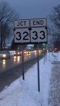
Eastern end in Port Washington
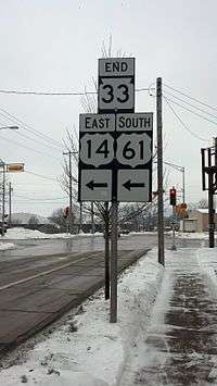
Western end in La Crosse
History
Prior to European settlement, the foot trail from Port Washington to Horicon was the most traveled of seven trails that met in Horicon Marsh.[2] A road was constructed to provide access from Lake Michigan to the fertile hunting grounds of the marsh, to provide food for the crews of ships on the lake.
References
| Wikimedia Commons has media related to Wisconsin Highway 33. |
- Bessert, Chris. "Wisconsin Highways: Highways 30-39 (Highway 33)". Wisconsin Highways. Retrieved 2007-03-20.
- Native Americans (U.S. Fish and Wildlife services)
This article is issued from Wikipedia. The text is licensed under Creative Commons - Attribution - Sharealike. Additional terms may apply for the media files.