Wheatland, Oklahoma
Wheatland is a neighborhood located on State Highway 152 in southwestern Oklahoma City, Oklahoma.[2] The post office opened February 10, 1902. That same year, the town church was built.[3] The ZIP Code is 73097. It was formally a rural town, but it was annexed by Oklahoma City.[4] The town was named after its main crop, wheat.[5]

Main Street in Wheatland, 2019

Wheatland, Oklahoma in 1889
Wheatland | |
|---|---|
 Wheatland Location within the state of Oklahoma  Wheatland Wheatland (the United States) | |
| Coordinates: 35°23′52″N 97°39′8″W | |
| Country | United States |
| State | Oklahoma |
| County | Oklahoma |
| Elevation | 1,310 [1] ft (Formatting error: invalid input when rounding m) |
| Population (2000) | |
| • Total | 39 |
| Time zone | UTC-6 (Central (CST)) |
| • Summer (DST) | UTC-5 (CDT) |
| ZIP codes | 73097, 73169 |
References
- https://roadsidethoughts.com/ok/wheatland-xx-oklahoma-profile.htm
- Oklahoma City, OK (Wheatland). Neighborhood Scout. https://www.neighborhoodscout.com/ok/oklahoma-city/wheatland#overview
- Culver, Galen. "Great State: No Longer a Town, Wheatland Church Still Carries the Name after 125 Years." KFOR, 2014. https://kfor.com/2014/11/10/great-state-no-longer-a-town-wheatland-church-still-carries-the-name-after-125-years/
- Culver, Galen. "Great State: No Longer a Town, Wheatland Church Still Carries the Name after 125 Years." KFOR, 2014. https://kfor.com/2014/11/10/great-state-no-longer-a-town-wheatland-church-still-carries-the-name-after-125-years/
- Wheatland. ePodunk. http://www.epodunk.com/cgi-bin/genInfo.php?locIndex=16209
Municipalities and communities of Oklahoma County, Oklahoma, United States | ||
|---|---|---|
| Cities | 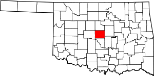 Oklahoma County map | |
| Towns | ||
| Unincorporated communities | ||
| Footnotes | ‡This populated place also has portions in an adjacent county or counties | |
This article is issued from Wikipedia. The text is licensed under Creative Commons - Attribution - Sharealike. Additional terms may apply for the media files.