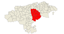
Valles Pasiegos
Valles Pasiegos is an administrative comarca in Cantabria, Spain. It is formed by the valleys of the Pas and Miera rivers, each one being a natural comarca of its own.
Valles Pasiegos | |
|---|---|
Coat of arms | |
 | |
| Country | |
| Autonomous community | Cantabria |
| Province | Cantabria |
| Capital | Villacarriedo |
| Municipalities | |
| Area | |
| • Total | 599 km2 (231 sq mi) |
| Population | |
| • Total | 23,257 |
| • Density | 39/km2 (100/sq mi) |
| Demonym(s) | pasiego, -a |
| Time zone | UTC+1 (CET) |
| • Summer (DST) | UTC+2 (CEST) |
Municipalities
The comarca consists of thirteen municipalities, listed below with their areas and populations:
| Name | Area (km2) |
Population (2001)[1] |
Population (2011)[2] |
Population (2018)[3] |
|---|---|---|---|---|
| Castañeda | 19.2 | 1,549 | 2,524 | 2,809 |
| Corvera de Toranzo | 49.5 | 2,128 | 2,158 | 2,041 |
| Luena | 90.5 | 872 | 694 | 601 |
| Puente Viesgo | 36.1 | 2,326 | 2,869 | 2,868 |
| San Pedro del Romeral | 57.4 | 621 | 507 | 466 |
| San Roque de Riomiera | 35.7 | 482 | 423 | 370 |
| Santa María de Cayón | 48.2 | 6,355 | 9,076 | 9,060 |
| Santiurde de Toranzo | 36.8 | 1,640 | 1,596 | 1,823 |
| Saro | 17.8 | 528 | 507 | 512 |
| Selaya | 39.3 | 1,948 | 2,007 | 1,891 |
| Vega de Pas | 87.5 | 1,011 | 828 | 775 |
| Villacarriedo | 50.7 | 1,755 | 1,749 | 1,604 |
| Villafufre | 30.1 | 1,149 | 1,113 | 1,029 |
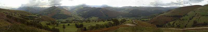
Pas valley
The Pas-Pisueña valley is located in the autonomous community of Cantabria, and through it flow the Pas River and its main tributary, the Pisueña River, which joins the Pas in the township of Vargas, part of the municipality of Puente Viesgo.
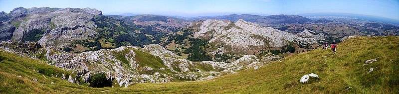
Miera valley
The Miera valley is a natural valley located in the autonomous community of Cantabria, travelled by the Miera River. It is in itself a natural comarca, and the narrowest of the Cantabrian valleys. Its slopes are most noticeable and its peaks very high (Castro Valnera at 1,707 m over sea level).
The valley occupies partially or totally the municipalities of Soba, San Roque de Riomiera, Miera, Liérganes, Riotuerto, Medio Cudeyo and Ruesga (Calseca enclave).
In its morphology are remarkable the sandstones and limestones, and the vast deposits of debris originated by ancient moraines from glaciers in its highest part. It also features large karstic areas. Nevertheless, some of its glacial valley characteristics have been modified in some points by the torrential nature of the Miera River near its source.
The higher basin of the Miera has an abrupt relief, not suitable for the human habitat. In spite of that, caves with prehistoric settlements have been discovered in Piélagos, Rascaño and Salitre, one of the highest altitude (450 m over sea level) stations with paleolithic art.
The medium valley of the Miera River, that mostly coincides with the municipality of Miera, is trapped between the abrupt karstic limestone pavements of Porracolina to the East, and Las Enguizas to the West, both belonging to the Urgonian Complex.
In both limestone blocks, important karstification phenomenons take place; there have been relevant explorations in these complexes and solved labyrinths in the caves of Alto del Tejuelo. Between them flows the Miera River, through the Escudo de Cabuérniga fault; with a diapir appearing from it between the villages of Linto and Miera and breaking the geologic continuity of the river course.
The chalky mountain mass of Las Enguizas sits directly over the silicon materials of the Early Cretaceous that make the hydrologic base of its four most important hydrologic systems and its cavities, partially studies in the case of El Cuevo de Noja-Fuente Fría and the Castrejón-Cubillo del Machorro network. They are structurally simpler systems than those of Porracolina, because the slope of the waterproof lower-cretaceous base has generated alignments perpendicular to the valleys axis.
In the lower course the most remarkable spots are the caves with prehistoric occupation: La Fuente del Francés (Hoznayo), La Garma (Omoño) and Los Moros (San Vitores). During the 16th century the economic life of this valley was focused around the lower course, towards Liérganes; years later in the 18th century a small industry had been established with the Royal Artillery Factory of La Cavada, which supplied weapons to the ships built in the Guarnizo and Colindres shipyards.
This zone gave many emigrants to Andalusia and the Indies. It is a cradle of many distinguished Indianos like Juan de la Cuesta Mercadillo, who was the builder of the La Rañada Palace in Liérganes; Ramón Pelayo de la Torriente (Marquis of Valdecilla), who developed many important constructions in the region and other points of Spain during the first third of the 20th century, mainly linked to education and public health.
References
- Census at 1 November 2001: Instituto Nacional de Estadística, Madrid.
- Census at 1 November 2011: Instituto Nacional de Estadística, Madrid.
- Estimate at 1 January 2018: Instituto Nacional de Estadística, Madrid.
External links
- (in Spanish) Pasiegan Valleys