Tysnes
Tysnes (Urban East Norwegian: [ˈtŷːsneːs]) is a municipality in Vestland county, Norway. It is located in the traditional district of Sunnhordland. The administrative centre is the village of Uggdal. Other population centres in Tysnes include the villages of Våge and Onarheim. The island municipality is located in a group of islands near the mouth of the Hardangerfjorden. The majority of the municipal population lives on the island of Tysnesøya, the largest island in the municipality.[3]
Tysnes kommune | |
|---|---|
 The harbour in Våge | |
 Coat of arms 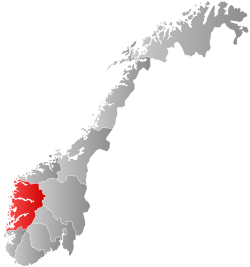 Vestland within Norway | |
 Tysnes within Vestland | |
| Coordinates: 59°59′54″N 05°34′38″E | |
| Country | Norway |
| County | Vestland |
| District | Sunnhordland |
| Established | 1 Jan 1838 |
| Administrative centre | Uggdal |
| Government | |
| • Mayor (2015) | Kåre Martin Kleppe (H) |
| Area | |
| • Total | 255.12 km2 (98.50 sq mi) |
| • Land | 245.18 km2 (94.66 sq mi) |
| • Water | 9.94 km2 (3.84 sq mi) 3.9% |
| Area rank | 283 in Norway |
| Population (2020) | |
| • Total | 2,869 |
| • Rank | 235 in Norway |
| • Density | 11.7/km2 (30/sq mi) |
| • Change (10 years) | 3.2% |
| Demonym(s) | Tysnesing[1] |
| Time zone | UTC+01:00 (CET) |
| • Summer (DST) | UTC+02:00 (CEST) |
| ISO 3166 code | NO-4616 |
| Official language form | Nynorsk[2] |
| Website | tysnes |
The 255-square-kilometre (98 sq mi) municipality is the 283rd largest by area out of the 356 municipalities in Norway. Tysnes is the 235th most populous municipality in Norway with a population of 2,869. The municipality's population density is 11.7 inhabitants per square kilometre (30/sq mi) and its population has increased by 3.2% over the previous 10-year period.[4][5]
General information
| Year | Pop. | ±% |
|---|---|---|
| 1951 | 3,866 | — |
| 1960 | 3,559 | −7.9% |
| 1970 | 3,019 | −15.2% |
| 1980 | 2,774 | −8.1% |
| 1990 | 2,915 | +5.1% |
| 2000 | 2,843 | −2.5% |
| 2010 | 2,779 | −2.3% |
| 2019 | 2,846 | +2.4% |
| Source: Statistics Norway. | ||
The historic parish of Tysnæs was established as a municipality on 1 January 1838 (see formannskapsdistrikt law). On 1 January 1907, the small portion of Tysnes located on the mainland (population: 67) was transferred to the neighboring municipality of Kvinnherad. The municipal borders have not changed since that time.[6]
Name
The municipality (originally the parish) are named after the old Tysnes farm (Old Norse: Týsnes), since the first Tysnes Church was built here. The first element is the genitive case of the name of the god Tyr and the last element is nes which means "headland".[7]
This is probably the only place in Norway named after the god Tyr. Several place names around the farm also have sacred meanings: Ve (holy place), Helgastein (holy rock), Godøy (the god's island), and Vevatnet (the holy lake). The old name of the big island of Tysnesøy was Njarðarlǫg (the district of the god Njord). Recently, a sun phenomenon connected to the original Tysnes headland has been discovered, and this seems to be the starting-point of the sacral name complex.[7]
Coat of arms
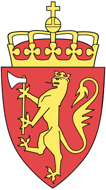
The coat of arms was granted on 28 October 1971. The arms are derived from the seal of the medieval Onarheim guild. Onarheim is a village on the island of Tysnesøya. It was historically a Viking Age center of power in the Sunnhordland region. The village is now part of Tysnes municipality. The arms show two crossed silver axes on a blue background. There is a silver chevron above the axes which was added to the municipal arms to distinguish it from the medieval arms.[8]
Churches
The Church of Norway has three parishes (sokn) within the municipality of Tysnes. It is part of the Sunnhordland prosti (deanery) in the Diocese of Bjørgvin.
| Parish (sokn) | Church name | Location of the church | Year built |
|---|---|---|---|
| Onarheim | Onarheim Church | Onarheim | 1893 |
| Reksteren og Uggdal | Reksteren Church | Reksteren | 1937 |
| Uggdal Church | Uggdal | 1876 | |
| Tysnes | Tysnes Church | Våge | 1868 |
Government
All municipalities in Norway, including Tysnes, are responsible for primary education (through 10th grade), outpatient health services, senior citizen services, unemployment and other social services, zoning, economic development, and municipal roads. The municipality is governed by a municipal council of elected representatives, which in turn elect a mayor.[9] The municipality falls under the Sunnhordland District Court and the Gulating Court of Appeal.
Municipal council
The municipal council (Kommunestyre) of Tysnes is made up of 21 representatives that are elected to four year terms. The party breakdown of the council is as follows:
| Party Name (in Nynorsk) | Number of representatives | |
|---|---|---|
| Labour Party (Arbeidarpartiet) | 4 | |
| Progress Party (Framstegspartiet) | 2 | |
| Conservative Party (Høgre) | 8 | |
| Christian Democratic Party (Kristeleg Folkeparti) | 1 | |
| Centre Party (Senterpartiet) | 6 | |
| Total number of members: | 21 | |
| Party Name (in Nynorsk) | Number of representatives | |
|---|---|---|
| Labour Party (Arbeidarpartiet) | 7 | |
| Progress Party (Framstegspartiet) | 2 | |
| Conservative Party (Høgre) | 5 | |
| Christian Democratic Party (Kristeleg Folkeparti) | 2 | |
| Centre Party (Senterpartiet) | 4 | |
| Liberal Party (Venstre) | 1 | |
| Total number of members: | 21 | |
| Party Name (in Nynorsk) | Number of representatives | |
|---|---|---|
| Labour Party (Arbeidarpartiet) | 6 | |
| Progress Party (Framstegspartiet) | 4 | |
| Conservative Party (Høgre) | 4 | |
| Christian Democratic Party (Kristeleg Folkeparti) | 3 | |
| Centre Party (Senterpartiet) | 2 | |
| Liberal Party (Venstre) | 2 | |
| Total number of members: | 21 | |
| Party Name (in Nynorsk) | Number of representatives | |
|---|---|---|
| Labour Party (Arbeidarpartiet) | 2 | |
| Progress Party (Framstegspartiet) | 4 | |
| Conservative Party (Høgre) | 3 | |
| Christian Democratic Party (Kristeleg Folkeparti) | 3 | |
| Centre Party (Senterpartiet) | 4 | |
| Liberal Party (Venstre) | 3 | |
| Cross-Party List (Tverrpolitisk liste) | 2 | |
| Total number of members: | 21 | |
| Party Name (in Nynorsk) | Number of representatives | |
|---|---|---|
| Labour Party (Arbeidarpartiet) | 4 | |
| Progress Party (Framstegspartiet) | 3 | |
| Conservative Party (Høgre) | 3 | |
| Christian Democratic Party (Kristeleg Folkeparti) | 3 | |
| Centre Party (Senterpartiet) | 4 | |
| Liberal Party (Venstre) | 1 | |
| Cross-Party List (Tverrpolitisk liste) | 2 | |
| Total number of members: | 21 | |
| Party Name (in Nynorsk) | Number of representatives | |
|---|---|---|
| Labour Party (Arbeidarpartiet) | 4 | |
| Progress Party (Framstegspartiet) | 2 | |
| Conservative Party (Høgre) | 5 | |
| Christian Democratic Party (Kristeleg Folkeparti) | 6 | |
| Centre Party (Senterpartiet) | 3 | |
| Cross-Party List (Tverrpolitisk liste) | 3 | |
| Total number of members: | 23 | |
| Party Name (in Nynorsk) | Number of representatives | |
|---|---|---|
| Labour Party (Arbeidarpartiet) | 5 | |
| Progress Party (Framstegspartiet) | 2 | |
| Conservative Party (Høgre) | 3 | |
| Christian Democratic Party (Kristeleg Folkeparti) | 6 | |
| Centre Party (Senterpartiet) | 7 | |
| Total number of members: | 23 | |
| Party Name (in Nynorsk) | Number of representatives | |
|---|---|---|
| Labour Party (Arbeidarpartiet) | 4 | |
| Progress Party (Framstegspartiet) | 2 | |
| Conservative Party (Høgre) | 5 | |
| Christian Democratic Party (Kristeleg Folkeparti) | 5 | |
| Centre Party (Senterpartiet) | 9 | |
| Total number of members: | 25 | |
| Party Name (in Nynorsk) | Number of representatives | |
|---|---|---|
| Labour Party (Arbeidarpartiet) | 4 | |
| Conservative Party (Høgre) | 6 | |
| Christian Democratic Party (Kristeleg Folkeparti) | 4 | |
| Centre Party (Senterpartiet) | 10 | |
| Liberal Party (Venstre) | 1 | |
| Total number of members: | 25 | |
| Party Name (in Nynorsk) | Number of representatives | |
|---|---|---|
| Labour Party (Arbeidarpartiet) | 4 | |
| Conservative Party (Høgre) | 8 | |
| Christian Democratic Party (Kristeleg Folkeparti) | 5 | |
| Centre Party (Senterpartiet) | 7 | |
| Liberal Party (Venstre) | 1 | |
| Total number of members: | 25 | |
| Party Name (in Nynorsk) | Number of representatives | |
|---|---|---|
| Labour Party (Arbeidarpartiet) | 3 | |
| Conservative Party (Høgre) | 6 | |
| Christian Democratic Party (Kristeleg Folkeparti) | 6 | |
| Centre Party (Senterpartiet) | 6 | |
| Liberal Party (Venstre) | 2 | |
| Election list for Reksteren (Valliste for Reksteren) | 2 | |
| Total number of members: | 25 | |
| Party Name (in Nynorsk) | Number of representatives | |
|---|---|---|
| Election list for Reksteren (Valliste for Reksteren) | 2 | |
| Election list for Onarheim (Valliste for Onarheim) | 4 | |
| Election list for Uggdal (Valliste for Uggdal) | 9 | |
| Election list for Tysnes and Lunde school districts (Valliste for Tysnes og Lunde skulekrets) | 10 | |
| Total number of members: | 25 | |
| Party Name (in Nynorsk) | Number of representatives | |
|---|---|---|
| Local List(s) (Lokale lister) | 25 | |
| Total number of members: | 25 | |
| Party Name (in Nynorsk) | Number of representatives | |
|---|---|---|
| Local List(s) (Lokale lister) | 25 | |
| Total number of members: | 25 | |
| Party Name (in Nynorsk) | Number of representatives | |
|---|---|---|
| Labour Party (Arbeidarpartiet) | 2 | |
| Conservative Party (Høgre) | 3 | |
| Local List(s) (Lokale lister) | 20 | |
| Total number of members: | 25 | |
| Party Name (in Nynorsk) | Number of representatives | |
|---|---|---|
| Labour Party (Arbeidarpartiet) | 2 | |
| Conservative Party (Høgre) | 2 | |
| Local List(s) (Lokale lister) | 21 | |
| Total number of members: | 25 | |
| Party Name (in Nynorsk) | Number of representatives | |
|---|---|---|
| Labour Party (Arbeidarpartiet) | 3 | |
| Local List(s) (Lokale lister) | 22 | |
| Total number of members: | 25 | |
| Party Name (in Nynorsk) | Number of representatives | |
|---|---|---|
| Local List(s) (Lokale lister) | 32 | |
| Total number of members: | 32 | |
| Party Name (in Nynorsk) | Number of representatives | |
|---|---|---|
| List of workers, fishermen, and small farmholders (Arbeidarar, fiskarar, småbrukarar liste) | 1 | |
| Local List(s) (Lokale lister) | 31 | |
| Total number of members: | 32 | |
| Party Name (in Nynorsk) | Number of representatives | |
|---|---|---|
| List of workers, fishermen, and small farmholders (Arbeidarar, fiskarar, småbrukarar liste) | 2 | |
| Local List(s) (Lokale lister) | 30 | |
| Total number of members: | 32 | |
| Party Name (in Nynorsk) | Number of representatives | |
|---|---|---|
| Local List(s) (Lokale lister) | 30 | |
| Total number of members: | 30 | |
Geography
The municipality consists of a group of islands, located south of the city of Bergen where the Hardangerfjorden and the coastal archipelago meet. The Bjørnafjorden lies north of the municipality and the Langenuen strait runs along the western side of the municipality. The largest of these islands, named Tysnesøya, can be reached from the mainland either by ferry to the village of Våge on the north side of the island or by the road bridge constructed on the eastern side of the island. The second largest island is Reksteren, which is connected to Tysnesøya by a small road bridge.
References
- "Navn på steder og personer: Innbyggjarnamn" (in Norwegian). Språkrådet.
- "Forskrift om målvedtak i kommunar og fylkeskommunar" (in Norwegian). Lovdata.no.
- Store norske leksikon. "Tysnes" (in Norwegian). Retrieved 2015-01-22.
- Statistisk sentralbyrå (2020). "Table: 06913: Population 1 January and population changes during the calendar year (M)" (in Norwegian).
- Statistisk sentralbyrå (2020). "09280: Area of land and fresh water (km²) (M)" (in Norwegian).
- Jukvam, Dag (1999). "Historisk oversikt over endringer i kommune- og fylkesinndelingen" (PDF) (in Norwegian). Statistisk sentralbyrå.
- Rygh, Oluf (1910). Norske gaardnavne: Søndre Bergenhus amt (in Norwegian) (11 ed.). Kristiania, Norge: W. C. Fabritius & sønners bogtrikkeri. pp. 169–171.
- "Civic heraldry of Norway - Norske Kommunevåpen". Heraldry of the World. Retrieved 2020-02-02.
- Hansen, Tore, ed. (2016-05-12). "kommunestyre". Store norske leksikon (in Norwegian). Kunnskapsforlaget. Retrieved 2019-04-06.
- "Tall for Norge: Kommunestyrevalg 2019 - Vestland". Valg Direktoratet. Retrieved 2020-02-02.
- "Table: 04813: Members of the local councils, by party/electoral list at the Municipal Council election (M)" (in Norwegian). Statistics Norway.
- "Tall for Norge: Kommunestyrevalg 2011 - Hordaland". Valg Direktoratet. Retrieved 2020-02-02.
- "Kommunestyrevalget 1995" (PDF) (in Norwegian). Oslo-Kongsvinger: Statistisk sentralbyrå. 1996. Retrieved 2020-02-20.
- "Kommunestyrevalget 1991" (PDF) (in Norwegian). Oslo-Kongsvinger: Statistisk sentralbyrå. 1993. Retrieved 2020-02-20.
- "Kommunestyrevalget 1987" (PDF) (in Norwegian). Oslo-Kongsvinger: Statistisk sentralbyrå. 1988. Retrieved 2020-02-20.
- "Kommunestyrevalget 1983" (PDF) (in Norwegian). Oslo-Kongsvinger: Statistisk sentralbyrå. 1984. Retrieved 2020-02-20.
- "Kommunestyrevalget 1979" (PDF) (in Norwegian). Oslo: Statistisk sentralbyrå. 1979. Retrieved 2020-02-20.
- "Kommunevalgene 1975" (PDF) (in Norwegian). Oslo: Statistisk sentralbyrå. 1977. Retrieved 2020-05-10.
- "Kommunevalgene 1972" (PDF) (in Norwegian). Oslo: Statistisk sentralbyrå. 1973. Retrieved 2020-05-10.
- "Kommunevalgene 1967" (PDF) (in Norwegian). Oslo: Statistisk sentralbyrå. 1967. Retrieved 2020-05-10.
- "Kommunevalgene 1963" (PDF) (in Norwegian). Oslo: Statistisk sentralbyrå. 1964. Retrieved 2020-05-10.
- "Kommunevalgene og Ordførervalgene 1959" (PDF) (in Norwegian). Oslo: Statistisk sentralbyrå. 1960. Retrieved 2020-05-10.
- "Kommunevalgene og Ordførervalgene 1955" (PDF) (in Norwegian). Oslo: Statistisk sentralbyrå. 1957. Retrieved 2020-05-10.
- "Kommunevalgene og Ordførervalgene 1951" (PDF) (in Norwegian). Oslo: Statistisk sentralbyrå. 1952. Retrieved 2020-05-10.
- "Kommunevalgene og Ordførervalgene 1947" (PDF) (in Norwegian). Oslo: Statistisk sentralbyrå. 1948. Retrieved 2020-05-10.
- "Kommunevalgene og Ordførervalgene 1945" (PDF) (in Norwegian). Oslo: Statistisk sentralbyrå. 1947. Retrieved 2020-05-10.
- "Kommunevalgene og Ordførervalgene 1937" (PDF) (in Norwegian). Oslo: Statistisk sentralbyrå. 1938. Retrieved 2020-05-10.
- "Hipp, hipp hurra - Tysnes fyller 60 år". Tysnesbladet (in Norwegian). 2013-07-04.
External links
| Wikimedia Commons has media related to Tysnes. |
- Municipal fact sheet from Statistics Norway (in Norwegian)
- Tysnes municipality home page
- Tysnes newspaper (in Norwegian)
- Tysnesingen online newspaper (in Norwegian)
- Video about the sun phenomenon connected to the Tysnes headland, pre-Christian cult and the sacral place names in the area
 |
|  | |||