Transport in Afghanistan
Transport in Afghanistan is limited and in the developing stage. Much of the nation's road network was built during the 1960s but left to ruin during the 1980s and 90s wars. New national highways, roads, and bridges have been rebuilt in the last decade to help increase travel as well as trade with neighboring countries. In 2008, there were about 731,607 vehicles registered inside the country.


Landlocked Afghanistan has no seaports, but the Amu Darya river, which forms part of the nation's border with Turkmenistan, Uzbekistan, and Tajikistan, does have substantial traffic. Rebuilding of airports, roads, and rail services has led to rapid economic growth in recent years. The nation has about 43 airports and a much smaller number of heliports.[1]
Road
Most major roads were built in the 1960s with assistance from the United States and the Soviet Union. The Soviets built a road and tunnel through the Salang pass in 1964, connecting northern and eastern Afghanistan. A highway connecting the principal cities of Herat, Kandahar, Ghazni, and Kabul with links to highways in neighboring Pakistan formed the primary road system.
The network includes 12,350 kilometers of paved roads and 29,800 kilometers of unpaved roads, for an approximate total road system of 42,150 kilometers as of 2006.[1] Traffic in Afghanistan is right hand, with about 731,607 registered vehicles in the country (2008 estimate).[2] The Afghan government passed a law banning the import of cars older than 10 years.
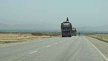
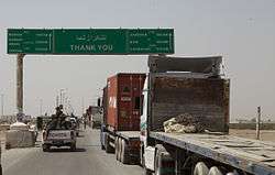
Long distant road journeys are made by company-owned Mercedes-Benz coach buses or various types of vans, trucks and private cars.[3] Although a nationwide bus service is available between major cities, flying is safer, especially for foreigners. There are occasional highway robberies by bandits or militant groups. The roads are also dangerous due to accidents and lack of security forces.
The highway system is currently going through a reconstruction phase. Most of the regional roads are also being repaired or improved. For the last 30 years, the poor state of the Afghan transportation and communication networks has further fragmented and hampered the struggling economy.
The following is a partial list of national roads:
- Kabul-Kandahar Highway (A-1)
- Kabul-Jalalabad Road (A-1), which links the national capital to the eastern city of Jalalabad and the Pakistani border at Torkham
- Kabul-Gardez Highway
- Kabul-Herat Highway (A-77)
- Kabul-Mazar Highway (A-76)
- Kabul-Fayzabad Highway
- Kandahar-Bamyan Highway
- Kandahar-Boldak Highway[4]
- Kandahar-Herat Highway
- Kandahar-Tarin Kowt Highway
- Kunduz-Khomri Highway
- Herat-Islam Qala Highway
- Herat-Mazar Highway
- Route Trident (Lashkar Gah to Gereshk)
- Delaram-Zaranj Highway
- Gardez-Pathan Highway in Paktia Province (still under construction as of February 2015)
A road bridge linking Tajikistan and Afghanistan, which cost $37 million, was inaugurated in 2007. The bridge, nearly 700 metres long and 11 metres across, straddles the Panj river which forms a natural border between the two countries, between the ports of Nizhny Panj on the Tajik side and Sher Khan Bandar in Afghanistan.[5] The Delaram-Zaranj highway was constructed with Indian assistance and was inaugurated in January 2009.[6]


Due to the lack of public urban transport systems, taxis are highly popular in cities like Kabul.
Rail

Afghanistan-Uzbekistan rail connection
There is a 75-kilometer-long rail line between Uzbekistan and the northern Afghan city of Mazar-i-Sharif, all of which is built to 1,520 mm (4 ft 11 27⁄32 in) broad gauge.[7] The line begins from Termez and crosses the Amu Darya river on the Soviet-built Afghanistan–Uzbekistan Friendship Bridge, finally reaching a site next to the Mazar-i-Sharif Airport. The Afghan government expects to have the rail line extended to Kabul and then to the eastern border town of Torkham, connecting with Pakistan Railways. The work is carried out by China Metallurgical Group Corporation (MCC).[8] For strategic reasons, past Afghan governments preferred to discourage the construction of railways, which could aid foreign interference in Afghanistan by Britain or Russia.[9] The river is the border between the two countries, and the stretch of track which lies within Afghanistan (from the Peace Bridge to the terminus near Herat airport is 75 km in length.
Turkmenistan-Afghanistan rail connections
A 10-kilometer-long 1,520 mm (4 ft 11 27⁄32 in) broad gauge line extends from Serhetabat in Turkmenistan to the town of Torghundi in Afghanistan, which is about 115 km to the north of Herat. An upgrade of this Soviet-built line, to renovate and connect the line from Torghundi to Herat, began in 2017.[10]
A second rail connection between the two countries is that which extends from Aqina dry port in Faryab province of Afghanistan, via Imamnazar (or Ymamnazar), to Atamyrat (a.k.a Kerki), where it connects with the Turkmen rail network.[11] At present, no more than 13.5 km of track exists within Afghanistan (from Aqina to the Imamnazar border), the rest being in Turkmenistan, but extensions into Afghanistan are afoot. An initial extension of 58 kilometres (36 mi) to Andkhoy is under construction.[12] The line is expected to be extended by 300 kilometers to other northern provinces of Afghanistan.[13]
Iranian border
The nearest railway line in Iran is a 1,435 mm (4 ft 8 1⁄2 in) standard gauge line which terminates at Mashhad.[14] The most convenient point on that line to draw a connection to Afghanistan is near the town of Khaf, not far from Mashhad. A line from thereabouts is being extended 191 kilometers east to Herat, of which 77 km is located inside Iran and the remaining 114 km in Afghanistan.[15]
Pakistan border
Two broad gauge 1,676 mm (5 ft 6 in) Pakistan Railways lines terminate near the border at Chaman in Balochistan near the Khojak Pass; and at Torkham, the border town near the Khyber Pass. Various proposals exist to extend these lines on to Kandahar and Kabul respectively. In 2010, Pakistan and Afghanistan signed a Memorandum of understanding for going ahead with the laying of rail tracks between the two countries. Work on the proposed project was set to start in late 2010.[16]
Air


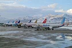
Air transport in Afghanistan is provided by Ariana Afghan Airlines, Afghan Jet International, East Horizon Airlines, Kam Air, Pamir Airways, and Safi Airways. Airlines from a number of nations also provide air services to fly in and out of the country. These include Air India, Emirates, Gulf Air, Iran Aseman Airlines, Pakistan International Airlines, Turkish Airlines and others.
The nation has at least four international airports, including the Hamid Karzai International Airport (Kabul International Airport) followed by Herat International Airport, Kandahar International Airport, and Mazar-e Sharif International Airport. There are a total of about 43 airports. Twenty-five of them have paved runways. Four of them have runways over 3,000 meters; three have runways between about 2,500 and 3,000 meters; eight have runways between 1500 and 2500 meters; and two have runways under 1000 meters.
- Hamid Karzai International Airport (3500 m runway) is the nation's largest airport and the primary hub for international civilian flights.
- Kandahar International Airport (3200 m runway) is a dual-use airport serving southern Afghanistan.
- Mazar-e Sharif International Airport (3100 m runway) is a dual-use airport serving the northern and central portions of the country.
- Herat International Airport (2600 m runway) is the primary civil airport for the western portion of the country.
- Jalalabad Airport (1800 m runway).
Bagram Air Base is used by NATO-led forces. It has heavy military traffic, especially helicopters. It can also handle larger airliners such as Boeing 747s, C-5 Galaxy and C-17 Globemaster III military cargo planes. KBR and some other companies fly into and out of Bagram on a regular basis.
Water
The chief inland waterway of land-locked Afghanistan is the Amu Darya River which forms part of Afghanistan's northern border. The river handles barge traffic up to about 500 metric tons. The main river ports are located at Kheyrabad and Shir Khan Bandar.
Pipelines
There are petroleum pipelines from Bagram into Uzbekistan and Shindand into Turkmenistan. These pipelines have been in disrepair and disuse for years. There are 180 kilometers of natural gas pipelines. The $10 billion Trans-Afghanistan Pipeline for delivering natural gas across Afghanistan into Pakistan is moving forward.
References
- "Afghanistan". The World Factbook. United States: Central Intelligence Agency (CIA). Retrieved 2017-12-01.
- "Afghanistan" (pdf). World Health Organization (WHO). Retrieved January 8, 2012.
- "Vehicles Rental in Afghanistan | Heavy Equipment Rentals | Afghan Logistics". AfghanRentals.
- "Afghanistan: Improved Roads Unlocks Access to Services and Opportunities". World Bank.
- Afghanistan-Tajikistan Bridge Links Central, South Asia Archived 2009-08-31 at the Wayback Machine
- "India hands over strategic highway to Afghanistan". The Hindu. 2007-07-12.
- "First major Afghan railway opens". Railway Gazette International. 25 August 2011. Retrieved 25 August 2011.
- Construction on Kabul-Torkham Railway to Start Soon, Ministry of Mines Says Archived 2013-11-09 at the Wayback Machine. Tamim Shaheer, October 18, 2011.
- "Railways of Afghanistan | Afghan railroads, past, present and future". www.andrewgrantham.co.uk.
- Kakar, Javed Hamim (1 December 2017). "Construction of Turkmen-Afghan railroad begins". Pajhwok Afghan News. Retrieved 1 December 2017.
- Salehai, Zarghona (28 November 2016). "Afghan-Turkmenistan railroad inaugurated". Pajhwok Afghan News. Retrieved 17 January 2017.
- Hejaab, Aslam (31 October 2016). "Work Begins On Aqina-Andkhoy Railway". ariananews.af. Retrieved 17 January 2017.
- "Work on Afghanistan-Turkmenistan railroad begins". Pajhwok Afghan News. 16 June 2013.
- "Modern construction methods mastered on Mashhad - Bafgh line". Railway Gazette International. 2007-07-01.
- Murray Hughes (2008-01-29). "Opening up Afghan trade route to Iran". Railway Gazette International.
- Pakistan, Afghanistan ink MoU on rail links by Javed Hamim Kakar, Pajhwok Afghan news, Jul 7, 2010 19:05. Footnote upgraded 2010-07-12.
- "Pointers". Railway Gazette International. 2008-06-15. Archived from the original on 2012-05-27.
External links
| Wikimedia Commons has media related to Transport in Afghanistan. |
![]()
Transport in Asia | |
|---|---|
| Sovereign states |
|
| States with limited recognition |
|
| Dependencies and other territories | |
| |