Torsken
Torsken is a former municipality that was located on the western coast of the large island of Senja in the old Troms county, Norway. The municipality existed from 1902 until its dissolution in 2020 when it was merged into the new Senja Municipality. The administrative centre of the municipality was the village of Gryllefjord. Other larger villages in Torsken municipality included the villages of Torsken, Medby, and Flakstadvåg.
Torsken kommune Doaskku suohkan | |
|---|---|
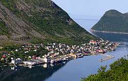
 View of Medby in Torsken | |
 Coat of arms 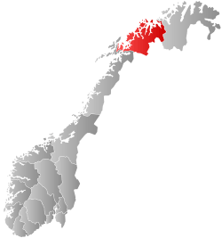 Troms within Norway | |
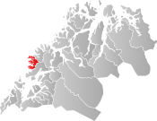 Torsken within Troms | |
| Coordinates: 69°17′47″N 17°02′11″E | |
| Country | Norway |
| County | Troms |
| District | Midt-Troms |
| Established | 1 Jan 1902 |
| Disestablished | 1 Jan 2020 |
| Administrative centre | Gryllefjord |
| Area | |
| • Total | 243.42 km2 (93.98 sq mi) |
| • Land | 235.30 km2 (90.85 sq mi) |
| • Water | 8.12 km2 (3.14 sq mi) 3.3% |
| Area rank | 310 in Norway |
| *Area at municipal dissolution. | |
| Population (2018) | |
| • Total | 943 |
| • Rank | 401 in Norway |
| • Density | 4/km2 (10/sq mi) |
| • Change (10 years) | -0.6% |
| Demonym(s) | Torskeværing[1] |
| Time zone | UTC+01:00 (CET) |
| • Summer (DST) | UTC+02:00 (CEST) |
| ISO 3166 code | NO-1928 |
| Official language form | Bokmål[2] |
| Preceded by | Berg in 1902 |
| Succeeded by | Senja in 2020 |
The historic Torsken Church in the village of Torsken dates back to the 18th century. Ånderdalen National Park was partially located inside the old borders of Torsken and neighboring Tranøy municipalities.
At the time of its dissolution as a municipality on 1 January 2020, the 243-square-kilometre (94 sq mi) municipality was the 310th largest by area out of the 422 municipalities in Norway. Torsken was also the 401st most populous municipality in Norway with a population of 943. The municipality's population density was 4 inhabitants per square kilometre (10/sq mi) and its population has decreased by 0.6% over the previous decade.[3][4]
General information
The municipality of Torsken was established on 1 January 1902 when it was separated from the municipality of Berg. The initial population of Torsken was 1,229. During the 1960s, there were many municipal mergers across Norway due to the work of the Schei Committee. On 1 January 1964, the Rødsand area of Torsken (population: 160) was transferred to the neighboring Tranøy Municipality.[5]
In March 2017, the Parliament of Norway voted to merge the municipalities of Berg, Torsken, Lenvik, and Tranøy. The new municipality will encompass the whole island of Senja plus part of the mainland. The new municipality will be established on 1 January 2020 as Senja Municipality.[6][7]
Name
The municipality (originally the parish) is named after the old Torsken farm (Old Norse: Þoskar), since the first Torsken Church was built there. The farm is named after Torsken mountain, and that name is probably derived from Norse þo(r)skr which means "cod". (Several mountains in Norway are named after their likeness with a fish.)[8]
Coat of arms
The coat of arms is from modern times; they were granted on 23 March 1990. The arms show a gold-colored anchor cross (Norwegian: ankerkors) on a black background. It is a symbol for both Christianity and the importance of the local harbor. The economy of Torsken is largely dependent on its harbors and an anchor is an appropriate symbol.[9]
Churches
The Church of Norway has one parish (sokn) within the municipality of Torsken. It is part of the Senja prosti (deanery) in the Diocese of Nord-Hålogaland.
| Parish (Sokn) | Church Name | Location of the Church | Year Built |
|---|---|---|---|
| Torsken | Torsken Church | Torsken | 1784 |
| Flakkstadvåg Chapel | Flakstadvåg | 1925 | |
| Gryllefjord Chapel | Gryllefjord | 1902 | |
| Medby Chapel | Medby | 1890 |
Economy
Most of the inhabitants live in the fishing village of Gryllefjord in the northern part of the municipality. The second most important village is Torsken, only a few kilometers to the south. Kaldfarnes/Medby, Grunnfarnes, and Flakstadvåg are other fishing villages further south. The municipality is close to the resources of the major fishing grounds off the Vesterålen archipelago, and 2004 landed 9.8 million tons of fish with a value of 76.3 million kr for fish-processing in Torsken, Gryllefjord, Kaldfarnes, and Grunnfarnes. Most people work in the fields of fishing or fish processing.
The municipality has few productive forests, but there are some spruce trees planted in sheltered areas. In the southern parts of Torsken there is some usable farmland. There are five farms with more than 5 decares (0.0050 km2; 0.0019 sq mi) of agricultural land in the entire municipality (as of 1999).[10]
Transportation
The Andenes–Gryllefjord Ferry that goes across the Andfjorden to Andenes on the island of Andøya is operated during about two months each summer. The road from the northern part of the municipality to Kaldfarnes, Grunnfarnes, and Flakstadvåg is far from direct. One must drive north and then east to Berg and then south to Tranøy before turning northwest and returning to Torsken. These are the only road connections from the rest of Norway to Torsken.
Government
All municipalities in Norway, including Torsken, are responsible for primary education (through 10th grade), outpatient health services, senior citizen services, unemployment and other social services, zoning, economic development, and municipal roads. The municipality is governed by a municipal council of elected representatives, which in turn elect a mayor.[11] The municipality falls under the Senja District Court and the Hålogaland Court of Appeal.
Municipal council
The municipal council (Kommunestyre) of Torsken was made up of 15 representatives that were elected to four year terms. The party breakdown of the final municipal council was as follows:
| Party Name (in Norwegian) | Number of representatives | |
|---|---|---|
| Labour Party (Arbeiderpartiet) | 9 | |
| Centre Party (Senterpartiet) | 6 | |
| Total number of members: | 15 | |
| Party Name (in Norwegian) | Number of representatives | |
|---|---|---|
| Labour Party (Arbeiderpartiet) | 7 | |
| Coastal Party (Kystpartiet) | 4 | |
| Centre Party (Senterpartiet) | 4 | |
| Total number of members: | 15 | |
| Party Name (in Norwegian) | Number of representatives | |
|---|---|---|
| Labour Party (Arbeiderpartiet) | 3 | |
| Conservative Party (Høyre) | 1 | |
| Coastal Party (Kystpartiet) | 2 | |
| Centre Party (Senterpartiet) | 4 | |
| Common list in Torsken (Felleslista i Torsken) | 1 | |
| Gryllefjord local list (Gryllefjord bygdeliste) | 4 | |
| Total number of members: | 15 | |
| Party Name (in Norwegian) | Number of representatives | |
|---|---|---|
| Labour Party (Arbeiderpartiet) | 2 | |
| Progress Party (Fremskrittspartiet) | 1 | |
| Coastal Party (Kystpartiet) | 1 | |
| Centre Party and free voters list (Senterpartiet og frie velgeres liste) | 5 | |
| Common list in Torsken (Felleslista i Torsken) | 2 | |
| Gryllefjord local list (Gryllefjord bygdeliste) | 4 | |
| Total number of members: | 15 | |
| Party Name (in Norwegian) | Number of representatives | |
|---|---|---|
| Labour Party (Arbeiderpartiet) | 5 | |
| Centre Party (Senterpartiet) | 6 | |
| Common list (Felleslista) | 5 | |
| Gryllefjord local list (Gryllefjord bygdeliste) | 3 | |
| Total number of members: | 19 | |
| Party Name (in Norwegian) | Number of representatives | |
|---|---|---|
| Labour Party (Arbeiderpartiet) | 3 | |
| Centre Party (Senterpartiet) | 7 | |
| Common list (Felleslista) | 4 | |
| Gryllefjord local list (Gryllefjord bygdeliste) | 5 | |
| Total number of members: | 19 | |
| Party Name (in Norwegian) | Number of representatives | |
|---|---|---|
| Labour Party (Arbeiderpartiet) | 5 | |
| Socialist Left Party (Sosialistisk Venstreparti) | 1 | |
| Common list (Felleslista) | 13 | |
| Total number of members: | 19 | |
| Party Name (in Norwegian) | Number of representatives | |
|---|---|---|
| Labour Party (Arbeiderpartiet) | 8 | |
| Conservative Party (Høyre) | 2 | |
| Christian Democratic Party (Kristelig Folkeparti) | 1 | |
| Centre Party (Senterpartiet) | 2 | |
| Torsken social democrat common list (Torsken sosialdemokratisk fellesliste) | 6 | |
| Total number of members: | 19 | |
| Party Name (in Norwegian) | Number of representatives | |
|---|---|---|
| Labour Party (Arbeiderpartiet) | 10 | |
| Conservative Party (Høyre) | 2 | |
| Christian Democratic Party (Kristelig Folkeparti) | 2 | |
| Centre Party (Senterpartiet) | 1 | |
| Torsken non-party list (Torsken upolitiske liste) | 3 | |
| Grunnfarnes common list (Grunnfarnes Felleslista) | 1 | |
| Total number of members: | 19 | |
| Party Name (in Norwegian) | Number of representatives | |
|---|---|---|
| Labour Party (Arbeiderpartiet) | 7 | |
| Conservative Party (Høyre) | 4 | |
| Christian Democratic Party (Kristelig Folkeparti) | 2 | |
| Centre Party (Senterpartiet) | 3 | |
| Torsken non-party list (Torsken upolitiske liste) | 3 | |
| Total number of members: | 19 | |
| Party Name (in Norwegian) | Number of representatives | |
|---|---|---|
| Labour Party (Arbeiderpartiet) | 7 | |
| Christian Democratic Party (Kristelig Folkeparti) | 4 | |
| Torsken non-party list (Torsken Upolitiske Liste) | 3 | |
| Midtbygda non-party list (Midtbygda Upolitiske Liste) | 5 | |
| Total number of members: | 19 | |
| Party Name (in Norwegian) | Number of representatives | |
|---|---|---|
| Labour Party (Arbeiderpartiet) | 6 | |
| Joint List(s) of Non-Socialist Parties (Borgerlige Felleslister) | 2 | |
| Local List(s) (Lokale lister) | 11 | |
| Total number of members: | 19 | |
| Party Name (in Norwegian) | Number of representatives | |
|---|---|---|
| Labour Party (Arbeiderpartiet) | 7 | |
| Local List(s) (Lokale lister) | 12 | |
| Total number of members: | 19 | |
| Party Name (in Norwegian) | Number of representatives | |
|---|---|---|
| Labour Party (Arbeiderpartiet) | 7 | |
| Joint List(s) of Non-Socialist Parties (Borgerlige Felleslister) | 4 | |
| Local List(s) (Lokale lister) | 4 | |
| Total number of members: | 15 | |
| Party Name (in Norwegian) | Number of representatives | |
|---|---|---|
| Labour Party (Arbeiderpartiet) | 4 | |
| Local List(s) (Lokale lister) | 11 | |
| Total number of members: | 15 | |
| Party Name (in Norwegian) | Number of representatives | |
|---|---|---|
| Labour Party (Arbeiderpartiet) | 6 | |
| Joint List(s) of Non-Socialist Parties (Borgerlige Felleslister) | 2 | |
| Local List(s) (Lokale lister) | 7 | |
| Total number of members: | 15 | |
| Party Name (in Norwegian) | Number of representatives | |
|---|---|---|
| Labour Party (Arbeiderpartiet) | 6 | |
| Conservative Party (Høyre) | 2 | |
| Local List(s) (Lokale lister) | 4 | |
| Total number of members: | 12 | |
| Party Name (in Norwegian) | Number of representatives | |
|---|---|---|
| Labour Party (Arbeiderpartiet) | 4 | |
| Christian Democratic Party (Kristelig Folkeparti) | 1 | |
| Joint List(s) of Non-Socialist Parties (Borgerlige Felleslister) | 4 | |
| Local List(s) (Lokale lister) | 3 | |
| Total number of members: | 12 | |
| Party Name (in Norwegian) | Number of representatives | |
|---|---|---|
| Labour Party (Arbeiderpartiet) | 4 | |
| Christian Democratic Party (Kristelig Folkeparti) | 2 | |
| List of workers, fishermen, and small farmholders (Arbeidere, fiskere, småbrukere liste) | 2 | |
| Joint List(s) of Non-Socialist Parties (Borgerlige Felleslister) | 4 | |
| Total number of members: | 12 | |
| Party Name (in Norwegian) | Number of representatives | |
|---|---|---|
| Labour Party (Arbeiderpartiet) | 5 | |
| Joint List(s) of Non-Socialist Parties (Borgerlige Felleslister) | 5 | |
| Local List(s) (Lokale lister) | 2 | |
| Total number of members: | 12 | |
Geography
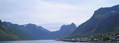
Torsken is a rugged area on the west coast of the island of Senja. Many different fjords cut into its mountainous coastline including Sifjorden, Selfjorden, Torskefjorden, Gryllefjorden, and Skipsfjorden. Between mountain peaks that range from 600 to 1,000 metres (2,000 to 3,300 ft), there are deep valleys and narrow depressions. Many of the valleys contain marshes or lakes. The bedrock under Torsken consists mostly of gneiss and granite.[10]
Climate
| Climate data for Gryllefjord, Torsken | |||||||||||||
|---|---|---|---|---|---|---|---|---|---|---|---|---|---|
| Month | Jan | Feb | Mar | Apr | May | Jun | Jul | Aug | Sep | Oct | Nov | Dec | Year |
| Daily mean °C (°F) | −2.5 (27.5) |
−2.5 (27.5) |
−1.4 (29.5) |
1.3 (34.3) |
5.4 (41.7) |
9.0 (48.2) |
11.5 (52.7) |
11.3 (52.3) |
7.8 (46.0) |
4.1 (39.4) |
0.6 (33.1) |
−1.6 (29.1) |
3.6 (38.5) |
| Average precipitation mm (inches) | 107 (4.2) |
93 (3.7) |
87 (3.4) |
76 (3.0) |
55 (2.2) |
67 (2.6) |
77 (3.0) |
91 (3.6) |
114 (4.5) |
150 (5.9) |
128 (5.0) |
130 (5.1) |
1,175 (46.3) |
| Source: Norwegian Meteorological Institute[29] | |||||||||||||
References
- "Navn på steder og personer: Innbyggjarnamn" (in Norwegian). Språkrådet.
- "Forskrift om målvedtak i kommunar og fylkeskommunar" (in Norwegian). Lovdata.no.
- Statistisk sentralbyrå (2018). "Table: 06913: Population 1 January and population changes during the calendar year (M)" (in Norwegian). Retrieved 2018-12-10.
- Statistisk sentralbyrå. "09280: Area of land and fresh water (km²) (M)" (in Norwegian). Retrieved 2018-12-10.
- Jukvam, Dag (1999). "Historisk oversikt over endringer i kommune- og fylkesinndelingen" (PDF) (in Norwegian). Statistisk sentralbyrå.
- "Senja kommune 2020" (in Norwegian). Retrieved 2017-09-09.
- Vermes, Thomas (2017-03-29). "Stortingsflertallet gjør fire Senja-kommuner til én". ABC Nyheter (in Norwegian). Retrieved 2017-09-09.
- Rygh, Oluf (1911). Norske gaardnavne: Troms amt (in Norwegian) (17 ed.). Kristiania, Norge: W. C. Fabritius & sønners bogtrikkeri. p. 77.
- "Civic heraldry of Norway - Norske Kommunevåpen". Heraldry of the World. Retrieved 2018-08-20.
- Store norske leksikon. "Torsken" (in Norwegian). Retrieved 2012-12-03.
- Hansen, Tore, ed. (2016-05-12). "kommunestyre". Store norske leksikon (in Norwegian). Kunnskapsforlaget. Retrieved 2018-08-20.
- "Table: 04813: Members of the local councils, by party/electoral list at the Municipal Council election (M)" (in Norwegian). Statistics Norway.
- "Tall for Norge: Kommunestyrevalg 2011 - Troms Romsa". Valg Direktoratet. Retrieved 2019-10-26.
- "Kommunestyrevalget 1995" (PDF) (in Norwegian). Oslo-Kongsvinger: Statistisk sentralbyrå. 1996. Retrieved 2020-03-18.
- "Kommunestyrevalget 1991" (PDF) (in Norwegian). Oslo-Kongsvinger: Statistisk sentralbyrå. 1993. Retrieved 2020-03-18.
- "Kommunestyrevalget 1987" (PDF) (in Norwegian). Oslo-Kongsvinger: Statistisk sentralbyrå. 1988. Retrieved 2020-03-18.
- "Kommunestyrevalget 1983" (PDF) (in Norwegian). Oslo-Kongsvinger: Statistisk sentralbyrå. 1984. Retrieved 2020-03-18.
- "Kommunestyrevalget 1979" (PDF) (in Norwegian). Oslo: Statistisk sentralbyrå. 1979. Retrieved 2020-03-18.
- "Kommunevalgene 1975" (PDF) (in Norwegian). Oslo: Statistisk sentralbyrå. 1977. Retrieved 2020-03-18.
- "Kommunevalgene 1972" (PDF) (in Norwegian). Oslo: Statistisk sentralbyrå. 1973. Retrieved 2020-03-18.
- "Kommunevalgene 1967" (PDF) (in Norwegian). Oslo: Statistisk sentralbyrå. 1967. Retrieved 2020-03-18.
- "Kommunevalgene 1963" (PDF) (in Norwegian). Oslo: Statistisk sentralbyrå. 1964. Retrieved 2020-03-18.
- "Kommunevalgene og Ordførervalgene 1959" (PDF) (in Norwegian). Oslo: Statistisk sentralbyrå. 1960. Retrieved 2020-03-18.
- "Kommunevalgene og Ordførervalgene 1955" (PDF) (in Norwegian). Oslo: Statistisk sentralbyrå. 1957. Retrieved 2020-03-18.
- "Kommunevalgene og Ordførervalgene 1951" (PDF) (in Norwegian). Oslo: Statistisk sentralbyrå. 1952. Retrieved 2020-03-18.
- "Kommunevalgene og Ordførervalgene 1947" (PDF) (in Norwegian). Oslo: Statistisk sentralbyrå. 1948. Retrieved 2020-03-18.
- "Kommunevalgene og Ordførervalgene 1945" (PDF) (in Norwegian). Oslo: Statistisk sentralbyrå. 1947. Retrieved 2020-03-18.
- "Kommunevalgene og Ordførervalgene 1937" (PDF) (in Norwegian). Oslo: Statistisk sentralbyrå. 1938. Retrieved 2020-03-18.
- "eKlima Web Portal". Norwegian Meteorological Institute. Archived from the original on 2004-06-14.
External links
- Municipal fact sheet from Statistics Norway (in Norwegian)
| Wikimedia Commons has media related to Torsken. |
| Look up torsken in Wiktionary, the free dictionary. |
| Wikivoyage has a travel guide for Troms. |
Troms og Finnmark county, Norway | |||||||||||||||||||||||
|---|---|---|---|---|---|---|---|---|---|---|---|---|---|---|---|---|---|---|---|---|---|---|---|
 |
|   | |||||||||||||||||||||
||
| Authority control |
|
|---|