Senja (municipality)
Senja is a municipality in Troms og Finnmark county, Norway. It was established on 1 January 2020 when the municipalities of Berg, Lenvik, Torsken, and Tranøy were merged into one municipality. It is located in the traditional district of Hålogaland. The administrative centre of the municipality is the town of Finnsnes. The municipality includes all of the island of Senja, the smaller surrounding islands, and part of the mainland between the Gisundet strait and the Malangen fjord.[3]
Senja kommune | |
|---|---|
 View of Finnsnes in Senja | |
 Coat of arms 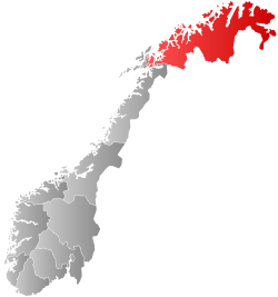 Troms og Finnmark within Norway | |
 Senja within Troms og Finnmark | |
| Coordinates: 69.0806°N 16.8031°E | |
| Country | Norway |
| County | Troms og Finnmark |
| District | Hålogaland |
| Established | 1 Jan 2020 |
| Administrative centre | Finnsnes |
| Government | |
| • Mayor (2020) | Tom-Rune Eliseussen (Sp) |
| Area | |
| • Total | 1,953.81 km2 (754.37 sq mi) |
| • Land | 1,859.68 km2 (718.03 sq mi) |
| • Water | 94.13 km2 (36.34 sq mi) 4.8% |
| Area rank | 40 in Norway |
| Population (2017) | |
| • Total | 14,851 |
| • Rank | 81 in Norway |
| • Density | 8/km2 (20/sq mi) |
| • Change (10 years) | 1.6% |
| Demonym(s) | Senjaværing Senjeværing[1] |
| Time zone | UTC+01:00 (CET) |
| • Summer (DST) | UTC+02:00 (CEST) |
| ISO 3166 code | NO-5421 |
| Official language form | Neutral[2] |
| Website | senja2020 |
The 1,954-square-kilometre (754 sq mi) municipality is the 40th largest by area out of the 356 municipalities in Norway. Senja is the 81st most populous municipality in Norway with a population of 14,851. The municipality's population density is 8 inhabitants per square kilometre (21/sq mi) and its population has increased by 1.6% over the previous 10-year period.[4][5]
General information
In March 2017, the Parliament of Norway voted to merge the municipalities of Berg, Torsken, Lenvik, and Tranøy. The new municipality was established on 1 January 2020 as Senja Municipality (Norwegian: Senja kommune).[6][7]
Name
The Old Norse form of the name must also have been Senja or perhaps Sændja. The meaning of the name is unknown, but it might be related to the verb sundra which means to "tear" or "split apart", possibly because the west coast of the island is torn and split by numerous small fjords. It might also be derived from a Proto-Norse form of the word Sandijōn meaning "(area) of sand" or "sandy island".[8][3]
Coat of arms
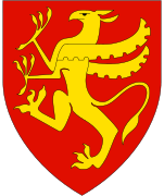
The coat of arms was approved for use starting on 1 January 2020. It is blue with a white outline of the Okshornan mountain with a green depiction of the northern lights above the mountain.[9]
Churches
The Church of Norway has four parishes (sokn) within the municipality of Senja. It is part of the Senja prosti (deanery) in the Diocese of Nord-Hålogaland.
| Parish (sokn) | Church name | Location of the church | Year built |
|---|---|---|---|
| Berg | Berg Church | Skaland | 1955 |
| Finnsæter Chapel | Finnsæter | 1982 | |
| Mefjordvær Chapel | Mefjordvær | 1916 | |
| Lenvik | Finnsnes Church | Finnsnes | 1979 |
| Lenvik Church | Bjorelvnes | 1879 | |
| Rossfjord Church | Rossfjordstraumen | 1822 | |
| Fjordgård Chapel | Fjordgård | 1976 | |
| Gibostad Chapel | Gibostad | 1939 | |
| Husøy Chapel | Husøy i Senja | 1957 | |
| Lysbotn Chapel | Lysnes | 1970 | |
| Sandbakken Chapel | Sandbakken | 1974 | |
| Torsken | Torsken Church | Torsken | 1784 |
| Flakkstadvåg Chapel | Flakstadvåg | 1925 | |
| Gryllefjord Chapel | Gryllefjord | 1902 | |
| Medby Chapel | Medby | 1890 | |
| Tranøy | Stonglandet Church | Stonglandseidet | 1896 |
| Tranøy Church | Tranøya | 1775 | |
| Skrolsvik Chapel | Skrollsvika | 1924 | |
| Vangsvik Chapel | Vangsvik | 1975 |
Government
All municipalities in Norway, including Senja, are responsible for primary education (through 10th grade), outpatient health services, senior citizen services, unemployment and other social services, zoning, economic development, and municipal roads. The municipality is governed by a municipal council of elected representatives, which in turn elects a mayor.[10] The municipality falls under the Senja District Court and the Hålogaland Court of Appeal.
Municipal council
The municipal council (Kommunestyre) of Senja is made up of 45 representatives that are elected to four year terms. The party breakdown of the council is as follows:
| Party Name (in Norwegian) | Number of representatives | |
|---|---|---|
| Labour Party (Arbeiderpartiet) | 13 | |
| Progress Party (Fremskrittspartiet) | 3 | |
| Green Party (Miljøpartiet De Grønne) | 1 | |
| Conservative Party (Høyre) | 8 | |
| Christian Democratic Party (Kristelig Folkeparti) | 1 | |
| Centre Party (Senterpartiet) | 11 | |
| Socialist Left Party (Sosialistisk Venstreparti) | 2 | |
| Senja List (Senjalista) | 6 | |
| Total number of members: | 45 | |
Geography
The island of Senja is located along the Troms county coastline with Finnsnes as the closest town. Senja is connected to the mainland by the Gisund Bridge. The municipalities located on Senja are Lenvik (part of which is on the mainland), Berg, Torsken, and Tranøy.[3]
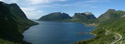
The northern coasts of Senja faces the open sea, the western coast faces the islands of Andøya and Krøttøya, the southern coast faces the islands of Andørja and Dyrøya. On the western coast, steep and rugged mountains rise straight from the sea, with some fishing villages (like Gryllefjord, Husøy) tucked into the small lowland areas between the mountains and the sea. The eastern and southern parts of the island are milder, with rounder mountains, forests, rivers and agriculture land.
Senja is often referred to as "Norway in miniature", as the island's diverse scenery reflects almost the entire span of Norwegian nature. Senja is well known domestically for its beautiful scenery, and is marketed as a tourist attraction.
Climate
Climate data from the village of Gibostad on the eastern shore of the island, facing the mainland during the base period of 1961-1990. The western side of the island, facing the Norwegian Sea, will have slightly milder but more windy winters.
| Climate data for Gibostad, Lenvik | |||||||||||||
|---|---|---|---|---|---|---|---|---|---|---|---|---|---|
| Month | Jan | Feb | Mar | Apr | May | Jun | Jul | Aug | Sep | Oct | Nov | Dec | Year |
| Average high °C (°F) | −1.9 (28.6) |
−1.8 (28.8) |
0.2 (32.4) |
3.6 (38.5) |
8.4 (47.1) |
12.9 (55.2) |
15.0 (59.0) |
14.6 (58.3) |
10.5 (50.9) |
5.8 (42.4) |
1.5 (34.7) |
−0.7 (30.7) |
5.7 (42.3) |
| Daily mean °C (°F) | −4.4 (24.1) |
−4.2 (24.4) |
−2.3 (27.9) |
1.0 (33.8) |
5.5 (41.9) |
9.7 (49.5) |
12.3 (54.1) |
11.6 (52.9) |
7.5 (45.5) |
3.3 (37.9) |
−0.8 (30.6) |
−3.2 (26.2) |
3.0 (37.4) |
| Average low °C (°F) | −7.1 (19.2) |
−7.0 (19.4) |
−5.5 (22.1) |
−2.1 (28.2) |
2.5 (36.5) |
6.8 (44.2) |
9.1 (48.4) |
8.3 (46.9) |
5.1 (41.2) |
1.3 (34.3) |
−3.1 (26.4) |
−5.8 (21.6) |
0.2 (32.4) |
| Average precipitation mm (inches) | 85 (3.3) |
80 (3.1) |
60 (2.4) |
54 (2.1) |
39 (1.5) |
47 (1.9) |
62 (2.4) |
71 (2.8) |
91 (3.6) |
119 (4.7) |
94 (3.7) |
98 (3.9) |
900 (35.4) |
| Average precipitation days (≥ 1 mm) | 13.4 | 12.4 | 11.5 | 10.7 | 9.2 | 10.6 | 13.2 | 12.4 | 14.3 | 16.0 | 14.7 | 15.6 | 154.0 |
| Source: Norwegian Meteorological Institute[12] | |||||||||||||
Attractions
Among the sights of the island are Ånderdalen National Park with coastal pine forests and mountains,[13] traditional fishing communities, and the Senja Troll, the world's largest troll. The southernmost municipality Tranøy also has several small museums documenting local history, among these the Halibut Museum ("Kveitmuseet") in Skrolsvik.
Media gallery
- Photos of Senja
 Bergsfjorden, Senja
 Husøy, Northern Senja
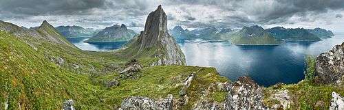 View from a ridge between Segla and Hesten, Senja, Norway,
.jpg) View from Gibostad towards Kistefjellet on the mainland
View from Gibostad towards Kistefjellet on the mainland.jpg) Seashore on the Senja island in Norway
Seashore on the Senja island in Norway Ersfjorden and near mountains
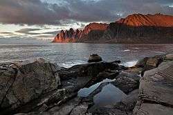
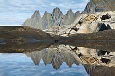 Okshornan peaks viewed from Tungeneset
References
- "Navn på steder og personer: Innbyggjarnamn" (in Norwegian). Språkrådet.
- "Forskrift om målvedtak i kommunar og fylkeskommunar" (in Norwegian). Lovdata.no.
- Thorsnæs, Geir, ed. (2018-05-09). "Senja". Store norske leksikon (in Norwegian). Kunnskapsforlaget. Retrieved 2018-08-25.
- Statistisk sentralbyrå (2020). "Table: 06913: Population 1 January and population changes during the calendar year (M)" (in Norwegian).
- Statistisk sentralbyrå (2020). "09280: Area of land and fresh water (km²) (M)" (in Norwegian).
- "Senja kommune 2020" (in Norwegian). Retrieved 2017-09-09.
- Vermes, Thomas (2017-03-29). "Stortingsflertallet gjør fire Senja-kommuner til én". ABC Nyheter (in Norwegian). Retrieved 2017-09-09.
- "Bidrag till Fennoskandiens språkliga förhistoria i tid och rum" (PDF) (in Swedish). Helsingfors Universitet. Retrieved 2015-12-27.
- Henriksen, Steinulf (2018-05-25). "Det viktigste Senja-våpen". Folkebladet (in Norwegian). Retrieved 2018-08-25.
- Hansen, Tore, ed. (2016-05-12). "kommunestyre". Store norske leksikon (in Norwegian). Kunnskapsforlaget. Retrieved 2019-10-26.
- "Tall for Norge: Kommunestyrevalg 2019 - Troms og Finnmark". Valg Direktoratet. Retrieved 2019-10-23.
- "eKlima Web Portal". Norwegian Meteorological Institute. Archived from the original on 2004-06-14.
- "Ånderdalen National Park" (in Norwegian). Directorate for nature management. Retrieved 2010-04-04.
Troms og Finnmark county, Norway | |||||||||||||||||||||||
|---|---|---|---|---|---|---|---|---|---|---|---|---|---|---|---|---|---|---|---|---|---|---|---|
 |
|   | |||||||||||||||||||||
||