Tone, Ibaraki
Tone (利根町, Tone-machi) is a town in Ibaraki Prefecture, Japan. As of September 2015, the town had an estimated population of 16,547, and a population density 665 persons per km². The total area is 24.9 km².
Tone 利根町 | |
|---|---|
Town | |
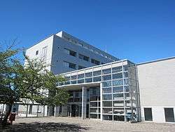 Tone Town Hall | |
 Flag  Seal | |
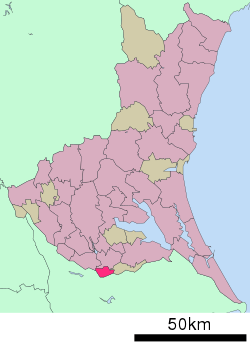 Location of Tone in Ibaraki Prefecture | |
 Tone | |
| Coordinates: 35°51′28″N 140°08′21.1″E | |
| Country | Japan |
| Region | Tōhoku |
| Prefecture | Ibaraki |
| District | Kitasōma |
| Area | |
| • Total | 24.90 km2 (9.61 sq mi) |
| Population (September 2015) | |
| • Total | 16,547 |
| • Density | 665/km2 (1,720/sq mi) |
| Time zone | UTC+9 (Japan Standard Time) |
| - Tree | Sakura |
| - Flower | Canna |
| - Bird | Yoshikiri (Acrocephalidae) |
| Phone number | 0297-68-2211 |
| Address | 841-1 Fukawa, Tone-machi, Kitasōma-gun, Ibaraki-ken 300-1696 |
| Website | http://www.town.tone.ibaraki.jp/ |
Geography
Tone is located in the flatlands in the very southern portion of Ibaraki Prefecture, bordered by Chiba Prefecture to the south. The Tone River, along with the Shin-Tone River and Kogawa River pass through the town.
Neighboring municipalities
- Ibaraki Prefecture
- Chiba Prefecture
- Abiko, Chiba
- Inzai, Chiba
- Sakae, Chiba
History
The area of present-day Tone was part of Shimōsa Province and was transferred to Ibaraki Prefecture in 1875 after the start of the Meiji period. The area was organized into the town of Fukawa and the villages of Fumi, and Momma within Kitasōma District, Ibaraki Prefecture with the establishment of the municipalities system on April 1, 1889.
The modern town of Tone was founded by the merger of Fukawa with Fumi and Momma on January 1, 1955.
Economy
Education
- Japan Wellness Sports University
Transportation
Railway
Tone is not served by any passenger railway line. The nearest station is Fusa on the Abiko branch line of the JR East’s Narita Line.
Highway
The town is not served by any national highway. Primary access is by Chiba Prefectural Route 4 and 170, and by Ibaraki Prefectural Route 11, 68 and 209.
Local attractions
Noted people from Tone
- Jun Sadogawa – manga artist
External links
| Wikimedia Commons has media related to Tone, Ibaraki. |
- Official Website (in Japanese)
Mito (capital) | ||
| Core city | ||
| Special city | ||
| Cities | ||
| Districts | ||
| Authority control |
|
|---|