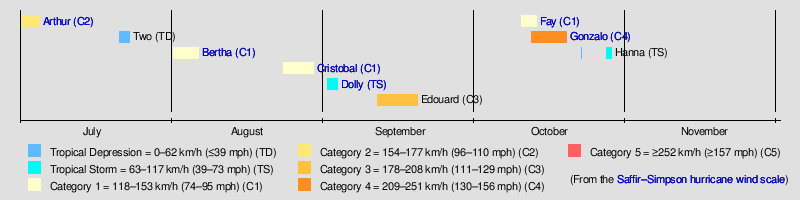
Timeline of the 2014 Atlantic hurricane season
The 2014 Atlantic hurricane season was an event in the annual hurricane season in the north Atlantic Ocean. It featured below-average tropical cyclone activity,[nb 1] with the fewest named storms since the 1997 season.[2] The season officially began on June 1, 2014 and ended on November 30, 2014. These dates, adopted by convention, historically describe the period in each year when most tropical systems form.[3] Even so, there were no named storms during either the opening or closing months of the season, as the first, Hurricane Arthur, developed on July 1, and the last, Tropical Storm Hanna, dissipated on October 28.
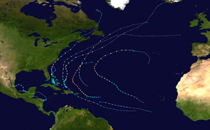
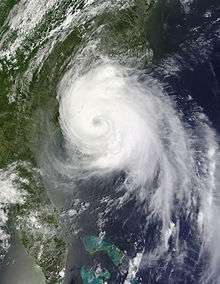
Altogether, eight tropical storms formed during the season, including six hurricanes of which two intensified into major hurricanes.[nb 2] There was also one tropical depression that failed to reach tropical storm strength. Impact throughout the year was widespread. Hurricane Arthur, which moved ashore near Cape Lookout, North Carolina on July 3 with 100 mph (160 km/h) winds, was the strongest hurricane to make landfall on the U.S. mainland since Hurricane Ike in 2008 (with 110 mph (180 km/h) winds).[5] The deadliest Atlantic storm of the season, Hurricane Cristobal, barely touched land at all as it moved northward along the Atlantic Gulf Stream, but was responsible for at least seven fatalities.[6] In October, Bermuda was struck twice, as hurricanes Fay and Gonzalo made landfall only six days apart (October 12 and 18 respectively), leaving much damage in their wakes.[5]
This timeline documents tropical cyclone formations, strengthening, weakening, landfalls, extratropical transitions, and dissipations during the season. It includes information that was not released throughout the season, meaning that data from post-storm reviews by the National Hurricane Center, such as a storm that was not initially warned upon, has been included.
By convention, meteorologists one time zone when issuing forecasts and making observations: Coordinated Universal Time (UTC), and also use the 24-hour clock (where 00:00 = midnight UTC).[7] In this time line, all information is listed by UTC first with the respective local time included in parentheses.
Timeline
June
June 1
- The 2014 Atlantic hurricane season officially begins.[3]
- No tropical cyclones form in the Atlantic Ocean during the month of June.
July
July 1
- 00:00 UTC (8:00 p.m. EDT, June 30) near 27.7°N 78.9°W – Tropical Depression One develops about 80 mi (130 km) north of Freeport, Bahamas.[8]
- 12:00 UTC (8:00 a.m. EDT) near 27.5°N 79.2°W – Tropical Depression One intensifies into Tropical Storm Arthur roughly 70 mi (110 km) east of Fort Pierce, Florida.[8]
July 3
- 00:00 UTC (8:00 p.m. EDT, July 2) near 30.1°N 79.2°W – Tropical Storm Arthur intensifies into a Category 1 hurricane approximately 145 mi (233 km) east-southeast of Savannah, Georgia.[8]
July 4
- 00:00 UTC (8:00 p.m. EDT, July 3) near 34.0°N 77.3°W – Hurricane Arthur intensifies into a Category 2 hurricane about 35 mi (56 km) east of Carolina Beach, North Carolina and attains peak winds of 100 mph (160 km/h).[8]
- 03:15 UTC (11:15 p.m. EDT, July 3) near 34.7°N 76.6°W – Hurricane Arthur makes its first landfall on Shackleford Banks, with winds of 100 mph (160 km/h).[8]
- 06:00 UTC (2:00 a.m. EDT) near 35.3°N 76.0°W – Hurricane Arthur attains a minimum barometric pressure of 973 mb (hPa; 28.73 inHg) roughly 15 mi (24 km) south of Engelhard, North Carolina.[8]
- 08:00 UTC (4:00 a.m. EDT) near 35.8°N 75.5°W – Hurricane Arthur makes its second landfall just north of Oregon Inlet, North Carolina, with winds of 100 mph (160 km/h).[8]
- 12:00 UTC (8:00 a.m. EDT) near 36.8°N 74.4°W – Hurricane Arthur weakens to a Category 1 hurricane approximately 85 mi (137 km) east of Virginia Beach, Virginia.[8]
July 5
- 06:00 UTC (2:00 a.m. EDT) near 42.3°N 67.6°W – Hurricane Arthur weakens to a tropical storm about 210 km (130 mi) east of Provincetown, Massachusetts.[8]
- 12:00 UTC (8:00 a.m. EDT) near 44.5°N 66.5°W – Tropical Storm Arthur becomes a post-tropical cyclone about 50 mi (80 km) north-northwest of Yarmouth, Nova Scotia,[9] and subsequently dissipates off the eastern coast of Labrador.[8]
July 21
- 12:00 UTC (8:00 a.m. AST) near 11.4°N 41.6°E – Tropical Depression Two develops roughly 1,120 mi (1,800 km) east-southeast of Barbados and simultaneously attains its peak intensity with maximum sustained winds of 35 mph (55 km/h) and a minimum barometric pressure of 1012 mb (hPa; 29.89 inHg).[10]
July 23
- 15:00 UTC (11:00 a.m. AST) near 14.0°N 56.0°W – Tropical Depression Two degenerates into a tropical wave about 365 mi (587 km) east-southeast of the Lesser Antilles.[11]
August
August 1
- 00:00 UTC (8:00 a.m. AST, July 31) near 12.2°N 54.6°W – Tropical Storm Bertha develops approximately 345 mi (555 km) east-southeast of Barbados.[12]
August 3
- 14:00 UTC (10:00 a.m. AST) near 21.8°N 71.9°W – Tropical Storm Bertha makes landfall on Middle Caicos, Turks and Caicos Islands, with winds of 45 mph (72 km/h).[12]
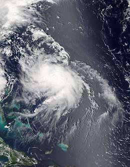
August 4
- 12:00 UTC (8:00 a.m. EDT) near 26.8°N 73.6°W – Tropical Storm Bertha intensifies into a Category 1 hurricane and simultaneously attains its peak intensity with maximum sustained winds of 80 mph (130 km/h) and a minimum barometric pressure of 998 mb (hPa; 29.47 inHg) about 195 mi (314 km) north-northeast of San Salvador Island, Bahamas.[12]
August 5
- 06:00 UTC (2:00 a.m. EDT) near 32.5°N 73.2°W – Hurricane Bertha weakens to a tropical storm roughly 300 mi (480 km) southeast of Wilmington, North Carolina.[12]
August 6
- 18:00 UTC (2:00 p.m. AST) near 40.8°N 61.3°W – Tropical Storm Bertha transitions into an extratropical cyclone approximately 290 mi (470 km)) south-southeast of Halifax, Nova Scotia, and subsequently degenerates into a trough southwest of Ireland.[12]
August 23
- 18:00 UTC (2:00 p.m. AST) near 21.5°N 72.2°W – Tropical Depression Four develops about 15 mi (24 km) southeast of Providenciales, Turks and Caicos Islands.[13][13]
August 24
- 06:00 UTC (2:00 a.m. AST) near 22.6°N 72.9°W – Tropical Depression Four intensifies into Tropical Storm Cristobal roughly 15 mi (24 km) north of Mayaguana, Bahamas.[13]
August 26
- 00:00 UTC (8:00 p.m. EDT, August 25) near 25.1°N 72.1°W – Tropical Storm Cristobal intensifies into a Category 1 hurricane approximately 165 mi (266 km) north-northeast of San Salvador Island, Bahamas.[13]
August 28
- 1800 UTC (2:00 p.m. AST) near 37.5°N 63.6°W – Hurricane Cristobal attains peak winds of 85 mph (137 km/h) about 360 mi (580 km) north of Bermuda.[13]
August 29
- 00:00 UTC (2:00 p.m. AST, August 28) near 39.1°N 58.8°W – Hurricane Cristobal attains a minimum barometric pressure of 965 mb (hPa; 28.50 inHg) roughly 575 mi (925 km) north-northeast of Bermuda.[13]
- 12:00 UTC (8:00 a.m. AST) near 44.2°N 49.0°W – Hurricane Cristobal transitions into an extratropical cyclone approximately 390 mi (630 km) east-southeast of Saint Pierre Island and subsequently merged with another extratropical cyclone.[13]
September
September 1
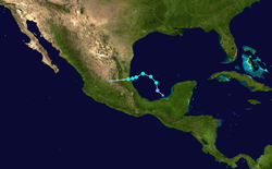
- 18:00 UTC (1:00 p.m. CDT) near 20.0°N 93.2°W – Tropical Depression Five develops about 340 mi (550 km) east-southeast of Tampico, Mexico over the Bay of Campeche.[14]
September 2
- 00:00 UTC (7:00 p.m. CDT, September 1) near 21.3°N 93.4°W – Tropical Depression Five intensifies into Tropical Storm Dolly roughly 295 mi (475 km) east-southeast of Tampico.[14]
- 12:00 UTC (7:00 a.m. CDT) near 22.8°N 95.6°W – Tropical Storm Dolly attains peak winds of 50 mph (80 km/h) approximately 150 mi (240 km) northeast of Tampico.[14]
September 3
- 01:00 UTC (8:00 p.m. CDT, September 2) near 22.0°N 97.4°W – Tropical Storm Dolly attains a minimum barometric pressure of 1000 mb (hPa; 29.53 inHg) about 35 mi (56 km) south-southeast of Tampico.[14]
- 04:00 UTC (11:00 p.m. CDT, September 2) near 21.9°N 97.7°W – Tropical Storm Dolly makes landfall about 40 mi (64 km) south-southeast of Tampico, with sustained winds of 45 mph (72 km/h).[15]
- 12:00 UTC (7:00 a.m CDT) near 21.7°N 98.8°W – Tropical Storm Dolly weakens to a tropical depression about 65 mi (105 km) west-southwest of Tampico[16] and later dissipates over the mountains of eastern Mexico.[14]
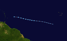
September 11
- 12:00 UTC (8:00 a.m. AST) near 15.8°N 36.5°W – Tropical Depression Six develops approximately 830 mi (1,340 km) west of the Cape Verde Islands.[17]
September 12
- 00:00 UTC (8:00 p.m. AST, September 11) near 17.2°N 39.2°E – Tropical Depression Six intensifies into Tropical Storm Edouard about 920 mi (1,480 km) west of the Cape Verde Islands.[17]
September 14
- 12:00 UTC (8:00 a.m. AST) near 24.4°N 50.3°W – Tropical Storm Edouard intensifies into a Category 1 hurricane roughly 1,035 mi (1,666 km) southeast of Bermuda.[17]

September 15
- 06:00 UTC (2:00 a.m. AST) near 26.5°N 54.0°W – Hurricane Edouard intensifies into a Category 2 hurricane approximately 765 mi (1,231 km) southeast of Bermuda.[17]
September 16
- 06:00 UTC (2:00 a.m. AST) near 29.5°N 57.3°W – Hurricane Edouard intensifies into a Category 3 major hurricane, about 485 mi (780 km) southeast of Bermuda.[17]
- 12:00 UTC (8:00 a.m. AST) near 30.6°N 57.8°W – Hurricane Edouard attains its peak intensity with maximum sustained winds of 120 mph (190 km/h) and a minimum barometric pressure of 955 mb (hPa; 28.20 inHg) roughly 415 mi (668 km) east of Bermuda.[17]
- 18:00 UTC (2:00 p.m. AST) near 31.7°N 57.7°W – Hurricane Edouard weakens to a Category 2 hurricane approximately 420 mi (680 km) east of Bermuda.[17]
September 17
- 12:00 UTC (8:00 a.m. AST) near 35.7°N 54.5°W – Hurricane Edouard weakens to a Category 1 hurricane about 645 mi (1,038 km) northeast of Bermuda.[17]
September 19
- 00:00 UTC (8:00 p.m. AST, September 18) near 39.9°N 40.1°W – Hurricane Edouard weakens to a tropical storm roughly 480 mi (770 km) west-southwest of the western Azores.[17]
- 18:00 UTC (2:00 p.m. AST) near 39.5°N 37.4°W – Tropical Storm Edouard transitions into a post-tropical cyclone approximately 460 mi (740 km) west of the western Azores, and subsequently merged with a frontal system.[17]
October
October 10
- 06:00 UTC (2:00 a.m. AST) near 22.7°N 62.4°W – Subtropical Storm Fay develops about 615 mi (990 km) south of Bermuda.[18]
October 11
- 06:00 UTC (2:00 a.m. AST) near 26.0°N 65.0°W – Subtropical Storm Fay transitions into a fully tropical cyclone roughly 435 mi (700 km) south of Bermuda.[18]

October 12
- 00:00 UTC (8:00 p.m. AST, October 11) near 16.4°N 55.9°W – Tropical Depression Eight develops approximately 390 mi (630 km) east of the Leeward Islands.[19]
- 06:00 UTC (2:00 a.m. AST) near 31.7°N 64.9°W – Tropical Storm Fay intensifies into a Category 1 hurricane about 40 mi (64 km) south of Bermuda.[18]
- 08:10 UTC (4:10 a.m. AST) near 32.3°N 64.7°W – Hurricane Fay attains peak winds of 80 miles per hour (130 km/h) and simultaneously makes landfall on Bermuda.[18]
- 12:00 UTC (8:00 a.m. AST) near 33.1°N 63.9°W – Hurricane Fay attains a minimum barometric pressure of 983 mb (hPa; 29.03 inHg) roughly 75 mi (121 km) northeast of Bermuda.[18]
- 12:00 UTC (8:00 a.m. AST) near 16.4°N 57.9°W – Tropical Depression Eight intensifies into Tropical Storm Gonzalo approximately 255 mi (410 km) of Antigua.[19]
- 18:00 UTC (2:00 p.m. AST) near 33.6°N 61.9°W – Hurricane Fay weakens to a tropical storm about 190 mi (310 km) northeast of Bermuda.[18]
October 13
- 00:00 (8:00 p.m. AST, October 12) near 33.9°N 59.0°W – Tropical Storm Fay degenerates into an open trough east-northeast of Bermuda.[18]
- 12:00 UTC (8:00 a.m. AST) near 17.0°N 61.5°W – Tropical Storm Gonzalo intensifies into a Category 1 hurricane roughly 10 mi (15 km) east-southeast of Antigua.[19]
- 14:30 UTC (10:30 a.m. AST) near 17.1°N 61.8°W – Hurricane Gonzalo makes landfall on Antigua with winds of 75 mph (120 km/h).[19]
- 22:45 UTC (6:45 p.m. AST) near 18.1°N 63.0°W – Hurricane Gonzalo makes landfall on Saint Martin with winds of 85 mph (135 km/h).[19]
- 23:15 UTC (7:15 p.m. AST) near 18.2°N 63.1°W – Hurricane Gonzalo makes landfall on Anguilla with winds of 85 mph (137 km/h).[19]
October 14
- 06:00 UTC (2:00 a.m. AST) near 19.1°N 64.0°W – Hurricane Gonzalo intensifies into a Category 2 hurricane approximately 40 mi (65 km) northeast of Anegada.[19]
- 18:00 UTC (2:00 p.m. AST) near 20.8°N 65.5°W – Hurricane Gonzalo intensifies into a Category 3 hurricane about 165 mi (266 km) north of San Juan, Puerto Rico.[19]
October 15
- 00:00 UTC (8:00 p.m. AST, October 14) near 21.7°N 66.2°W – Hurricane Gonzalo intensifies into a Category 4 hurricane roughly 225 mi (362 km) north of San Juan, Puerto Rico.[19]
- 18:00 UTC (2:00 p.m. AST) near 23.8°N 68.3°W – Hurricane Gonzalo weakens to a Category 3 hurricane approximately 245 mi (394 km) northeast of Cockburn Town, Turks and Caicos.[19]
October 16
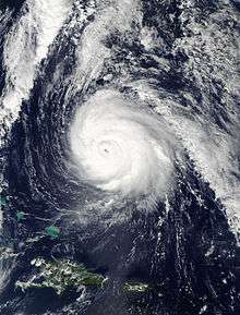
- 06:00 UTC (2:00 a.m. AST) near 25.0°N 68.7°W – Hurricane Gonzalo re-intensifies into a Category 4 hurricane about 295 mi (475 km) north-northeast of Cockburn Town, Turks and Caicos.[19]
- 12:00 UTC (8:00 a.m. AST) near 25.6°N 68.7°W – Hurricane Gonzalo attains its peak intensity with maximum sustained winds of 145 mph (233 km/h) and a minimum barometric pressure of 940 mb (hPa; 27.76 inHg) roughly 530 mi (850 km) south-southwest of Bermuda.[19]
October 17
- 12:00 UTC (8:00 a.m. AST) near 29.8°N 66.5°W – Hurricane Gonzalo weakens to a Category 3 hurricane for a second time approximately 195 mi (315 km) south-southwest of Bermuda.[19]
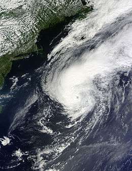
October 18
- 00:00 UTC (8:00 p.m. AST, October 17) near 32.2°N 64.9°W – Hurricane Gonzalo weakens to a Category 2 hurricane about 5 mi (10 km) south-southwest of Bermuda.[19]
- 00:30 UTC (8:30 p.m. AST, October 17) near 32.3°N 64.8°W – Hurricane Gonzalo makes landfall on Bermuda with sustained winds of 110 mph (180 km/h).[20]
October 19
- 06:00 UTC (2:00 a.m. AST) near 44.5°N 54.8°W – Hurricane Gonzalo weakens to a Category 1 hurricane roughly 170 mi (275 km) southeast of Saint Pierre Island.[19]
- 18:00 UTC (2:00 p.m. AST) near 50.6°N 44.8°W – Hurricane Gonzalo transitions into an extratropical cyclone approximately 415 mi (670 km) northeast of St. John's, Newfoundland, and is later absorbed by a cold front over the north-central Atlantic Ocean.[19]
October 22
- 00:00 UTC (7:00 p.m. CDT, October 21) near 19.5°N 93.3°W – Tropical Depression Nine develops about 175 mi (280 km) west of Campeche, Mexico.[21]
October 23
- 00:00 UTC (7:00 p.m. CDT, October 22) near 19.2°N 91.3°W – Tropical Depression Nine degenerates into a remnant low roughly 65 mi (105 km) southwest of Campeche, Mexico.[21]
October 27
- 00:00 UTC (7:00 p.m. EDT, October 26) near 15.1°N 82.0°W – Tropical Depression Nine regenerates approximately 80 mi (130 km) east of Cabo Gracias a Dios, Honduras–Nicaragua.[21]
- 06:00 UTC (2:00 a.m. EDT) near 15.0°N 82.4°W – Tropical Depression Nine intensifies into Tropical Storm Hanna and simultaneously attains its peak intensity with maximum sustained winds of 40 mph (64 km/h) and a minimum barometric pressure of 1005 mb (hPa; 29.68 inHg) about 50 mi (80 km) east of Cabo Gracias a Dios.[21]
- 16:00 UTC (12:00 p.m. EDT) near 14.9°N 83.3°W – Tropical Storm Hanna makes landfall about 15 mi (24 km) west-southwest of Cabo Gracias a Dios with sustained winds of 40 mph (64 km/h).[22]
- 18:00 UTC (2:00 p.m. EDT) near 14.9°N 83.5°W – Tropical Storm Hanna weakens to a tropical depression roughly 25 mi (40 km) west-southwest of Cabo Gracias a Dios.[21]
October 28
- 06:00 UTC (2:00 a.m. EDT) near 15.4°N 85.2°W – Tropical Depression Hanna degenerates into a remnant low approximately 60 mi (97 km) northeast of Catacamas, Honduras, and subsequently dissipates over northwestern Guatemala.[21]
November
- No tropical cyclones form in the Atlantic Ocean during the month of November.
November 30
- The 2000 Atlantic hurricane season officially ends.[3]
Notes
- An average Atlantic hurricane season, as defined by the National Oceanic and Atmospheric Administration, has 12 tropical storms, six hurricanes and two major hurricanes.[1]
- Hurricanes reaching Category 3 (111 miles per hour (179 km/h)) and higher on the 5-level Saffir–Simpson wind speed scale are considered major hurricanes.[4]
References
- "Background Information: North Atlantic Hurricane Season". College Park, Maryland: NOAA Climate Prediction Center. Retrieved July 14, 2020.
- Sullivan, Brian K. (November 25, 2014). "Snowy End to Hurricane Season That Many Never Noticed". Bloomberg News. Retrieved May 19, 2015.
- Dorst, Neal (June 1, 2018). "Hurricane Season Information". Frequently Asked Questions About Hurricanes. Miami, Florida: NOAA Atlantic Oceanographic and Meteorological Laboratory. Retrieved June 29, 2020.
- "Saffir-Simpson Hurricane Wind Scale". Miami, Florida: National Hurricane Center. Retrieved June 29, 2020.
- Wiltgen, Nick (December 1, 2014). "2014 Hurricane Season in Review: Eight Things We'll Remember". weather.com. Retrieved July 21, 2020.
- AP (August 29, 2014). "Hurricane Cristobal Kills 7: Two Swimmers Die in Rip Currents Off U.S. East Coast". Retrieved July 20, 2020 – via weather.com.
- "Understanding the Date/Time Stamps". miami, Florida: NOAA National Hurricane Center. Retrieved July 14, 2020.
- Berg, Robbie J. (April 20, 2015). Tropical Cyclone Report: Hurricane Arthur (PDF) (Report). Miami, Florida: National Hurricane Center. Retrieved May 15, 2015.
- Brown, Daniel P.; Pasch, Richard J. (July 5, 2014). Post-tropical Cyclone Arthur Intermediate Advisory Number 18A (Report). Miami, Florida: NWS National Hurricane Center. Retrieved July 21, 2020.
- Avila, Lixion A. (September 24, 2014). Tropical Cyclone Report: Tropical Depression Two (PDF) (Report). Miami, Florida: National Hurricane Center. pp. 2, 4. Retrieved May 15, 2015.
- Blake, Eric S. (July 23, 2014). Remnants of Two Advisory Number 8 (Report). Miami, Florida: NWS National Hurricane Center. Retrieved July 21, 2020.
- Blake, Eric S. (February 23, 2015). Tropical Cyclone Report: Hurricane Bertha (PDF) (Report). Miami, Florida: National Hurricane Center. Retrieved May 15, 2015.
- Pasch, Richard J. (February 11, 2015). Tropical Cyclone Report: Hurricane Cristobal (PDF) (Report). Miami, Florida: National Hurricane Center. Retrieved May 15, 2015.
- Beven, John L. (January 28, 2015). Tropical Cyclone Report: Tropical Storm Dolly (PDF) (Report). Miami, Florida: National Hurricane Center. pp. 2, 5. Retrieved May 16, 2015.
- Brown, Daniel P. (September 2, 2014). Tropical Storm Dolly Advisory Number 6 (Report). Miami, Florida: NWS National Hurricane Center. Retrieved July 21, 2020.
- Pasch, Richard J. (September 3, 2014). Tropical Depression Dolly Intermediate Advisory Number 7A (Report). Miami, Florida: NWS National Hurricane Center. Retrieved July 21, 2020.
- Stewart, Stacy R. (December 10, 2014). Tropical Cyclone Report: Hurricane Edouard (PDF) (Report). Miami, Florida: National Hurricane Center. Retrieved May 16, 2015.
- Kimberlain, Todd B. (April 24, 2015). Tropical Cyclone Report: Hurricane Fay (PDF) (Report). Miami, Florida: National Hurricane Center. Retrieved May 18, 2015.
- Brown, Daniel P. (March 4, 2015). Tropical Cyclone Report: Hurricane Gonzalo (PDF) (Report). Miami, Florida: National Hurricane Center. Retrieved May 18, 2015.
- Stewart, Stacy R. (October 17, 2014). Hurricane Gonzalo Tropical Cyclone Update (Report). Miami, Florida: NWS National Hurricane Center. Retrieved July 21, 2020.
- Cangialosi, John P. (December 16, 2014). Tropical Cyclone Report: Tropical Storm Hanna (PDF) (Report). Miami, Florida: National Hurricane Center. Retrieved May 18, 2015.
- Berg, Robbie J. (October 27, 2014). Tropical Storm Hanna Tropical Cyclone Update (Report). Miami, Florida: NWS National Hurricane Center. Retrieved July 21, 2020.
External links
| Wikimedia Commons has media related to 2014 Atlantic hurricane season. |