Teresita, Oklahoma
Teresita is an unincorporated community and census-designated place (CDP) in Cherokee County, Oklahoma, United States.[1] The population was 159 at the 2010 census.[2]
Teresita, Oklahoma | |
|---|---|
 Teresita | |
| Coordinates: 36°6′34″N 94°59′33″W | |
| Country | United States |
| State | Oklahoma |
| County | Cherokee |
| Area | |
| • Total | 9.7 sq mi (25.2 km2) |
| • Land | 9.7 sq mi (25.2 km2) |
| • Water | 0.0 sq mi (0.0 km2) |
| Population (2010) | |
| • Total | 159 |
| • Density | 16/sq mi (6.3/km2) |
| Time zone | UTC-6 (Central (CST)) |
| • Summer (DST) | UTC-5 (CST) |
| FIPS code | 40-72800 |
| GNIS feature ID | 1100881 |
Geography
Teresita is located in northern Cherokee County at the junction of the valleys of Spring Creek and Double Spring Creek. Spring Creek is a west-flowing tributary of the Neosho River. The community is 15 miles (24 km) north of Tahlequah, the Cherokee County seat.
According to the United States Census Bureau, the Teresita CDP has a total area of 9.7 square miles (25.2 km2), all land.[2]
References
- U.S. Geological Survey Geographic Names Information System: Teresita, Oklahoma
- "Geographic Identifiers: 2010 Demographic Profile Data (G001): Teresita CDP, Oklahoma". U.S. Census Bureau, American Factfinder. Archived from the original on February 18, 2015. Retrieved February 18, 2015.
Municipalities and communities of Cherokee County, Oklahoma, United States | ||
|---|---|---|
| City | 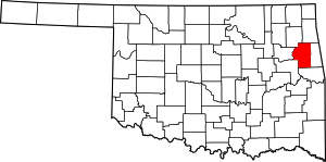 Cherokee County map | |
| Towns | ||
| CDPs | ||
| Other unincorporated communities | ||
| Indian reservation | ||
| Footnotes | ‡This populated place also has portions in an adjacent county or counties | |
This article is issued from Wikipedia. The text is licensed under Creative Commons - Attribution - Sharealike. Additional terms may apply for the media files.