Taylor, Alabama
Taylor is a town in Geneva and Houston counties in the U.S. state of Alabama. Taylor was first settled in the 1870s, named after an early family that helped secure the first post office. It was not incorporated until almost a century later in June 1967.[3] It is part of the Dothan, Alabama Metropolitan Statistical Area. At the 2010 census the population was 2,375,[4] up from 1,898 in 2000.
Taylor, Alabama | |
|---|---|
 Location of Taylor in Geneva County and Houston County, Alabama. | |
| Coordinates: 31°10′6″N 85°28′5″W | |
| Country | United States |
| State | Alabama |
| Counties | Houston, Geneva |
| Area | |
| • Total | 7.31 sq mi (18.94 km2) |
| • Land | 7.23 sq mi (18.73 km2) |
| • Water | 0.08 sq mi (0.21 km2) |
| Elevation | 331 ft (101 m) |
| Population (2010) | |
| • Total | 2,375 |
| • Estimate (2019)[2] | 2,428 |
| • Density | 335.73/sq mi (129.63/km2) |
| Time zone | UTC-6 (Central (CST)) |
| • Summer (DST) | UTC-5 (CDT) |
| ZIP codes | 36301, 36305 |
| Area code(s) | 334 |
| FIPS code | 01-75096 |
| GNIS feature ID | 0127718 |
| Website | www |
Geography
Taylor is located in western Houston County at 31°10′6″N 85°28′5″W (31.168331, -85.468016).[5] A rural portion of the town extends west into Geneva County. Taylor is bordered to the northeast by Dothan, to the southeast by Rehobeth, and to the southwest by Malvern. Alabama State Route 52 (Hartford Highway) passes through the northern part of Taylor, leading northeast 6 miles (10 km) to the center of Dothan and southwest 9 miles (14 km) to Slocomb.
According to the U.S. Census Bureau, Taylor has a total area of 7.5 square miles (19.4 km2), of which 7.4 square miles (19.1 km2) is land and 0.1 square miles (0.2 km2), or 1.09%, is water.[4]
Demographics
| Historical population | |||
|---|---|---|---|
| Census | Pop. | %± | |
| 1970 | 174 | — | |
| 1980 | 1,003 | 476.4% | |
| 1990 | 1,352 | 34.8% | |
| 2000 | 1,898 | 40.4% | |
| 2010 | 2,375 | 25.1% | |
| Est. 2019 | 2,428 | [2] | 2.2% |
| U.S. Decennial Census[6] 2013 Estimate[7] | |||
At the 2000 census there were 1,898 people, 699 households, and 552 families living in the town. The population density was 267.4 people per square mile (103.2/km2). There were 751 housing units at an average density of 105.8 per square mile (40.8/km2). The racial makeup of the town was 93.05% White, 3.79% Black or African American, 0.79% Native American, 0.26% Asian, 0.74% from other races, and 1.37% from two or more races. 1.11% of the population were Hispanic or Latino of any race.[8] Of the 699 households 47.2% had children under the age of 18 living with them, 61.9% were married couples living together, 12.3% had a female householder with no husband present, and 21.0% were non-families. 18.3% of households were one person and 4.6% were one person aged 65 or older. The average household size was 2.72 and the average family size was 3.09.
The age distribution was 31.7% under the age of 18, 7.6% from 18 to 24, 35.6% from 25 to 44, 17.9% from 45 to 64, and 7.2% 65 or older. The median age was 31 years. For every 100 females, there were 97.5 males. For every 100 females age 18 and over, there were 94.0 males.
The median household income was $40,664 and the median family income was $44,181. Males had a median income of $32,401 versus $22,321 for females. The per capita income for the town was $16,327. About 8.7% of families and 9.9% of the population were below the poverty line, including 12.8% of those under age 18 and 10.6% of those age 65 or over.
2010 census
At the 2010 census there were 2,375 people, 835 households, and 639 families living in the town. The population density was 329.9 people per square mile (127.7/km2). There were 966 housing units at an average density of 134.2 per square mile (51.9/km2). The racial makeup of the town was 87.5% White, 7.2% Black or African American, 0.8% Native American, 0.1% Asian, 2.4% from other races, and 2.1% from two or more races. 5.2% of the population were Hispanic or Latino of any race.[9] Of the 835 households 43.0% had children under the age of 18 living with them, 53.8% were married couples living together, 18.2% had a female householder with no husband present, and 23.5% were non-families. 19.3% of households were one person and 6.1% were one person aged 65 or older. The average household size was 2.84 and the average family size was 3.22.
The age distribution was 31.6% under the age of 18, 8.2% from 18 to 24, 30.4% from 25 to 44, 22.1% from 45 to 64, and 7.8% 65 or older. The median age was 31.5 years. For every 100 females, there were 96.3 males. For every 100 females age 18 and over, there were 89.5 males.
The median household income was $43,603 and the median family income was $49,500. Males had a median income of $31,795 versus $29,276 for females. The per capita income for the town was $16,833. About 16.9% of families and 21.0% of the population were below the poverty line, including 32.3% of those under age 18 and 10.5% of those age 65 or over.
References
- "2019 U.S. Gazetteer Files". United States Census Bureau. Retrieved June 29, 2020.
- "Population and Housing Unit Estimates". United States Census Bureau. May 24, 2020. Retrieved May 27, 2020.
- http://www.encyclopediaofalabama.org/article/h-3296
- "Geographic Identifiers: 2010 Demographic Profile Data (G001): Taylor town, Alabama". U.S. Census Bureau, American Factfinder. Retrieved October 26, 2016.
- "US Gazetteer files: 2010, 2000, and 1990". United States Census Bureau. 2011-02-12. Retrieved 2011-04-23.
- "U.S. Decennial Census". Census.gov. Retrieved June 6, 2013.
- "Annual Estimates of the Resident Population: April 1, 2010 to July 1, 2013". Retrieved June 3, 2014.
- "U.S. Census website". United States Census Bureau. Retrieved 2008-01-31.
- "U.S. Census website". United States Census Bureau. Retrieved 2015-07-24.
Municipalities and communities of Geneva County, Alabama, United States | ||
|---|---|---|
| Cities | 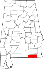 Map of Alabama highlighting Geneva County | |
| Towns | ||
| CDP | ||
| Unincorporated communities | ||
| Footnotes | ‡This populated place also has portions in an adjacent county or counties | |
Municipalities and communities of Houston County, Alabama, United States | ||
|---|---|---|
| City |  Map of Alabama highlighting Houston County | |
| Towns | ||
| Unincorporated communities | ||
| Footnotes | ‡This populated place also has portions in an adjacent county or counties | |