Slocomb, Alabama
Slocomb is a city in Geneva County, Alabama, United States. It is part of the Dothan, Alabama Metropolitan Statistical Area. At the 2010 census the population was 1,980. The community is named after postmaster Frank W. Slocomb.
Slocomb | |
|---|---|
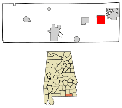 Location of Slocomb in Geneva County, Alabama | |
| Coordinates: 31°6′31″N 85°35′40″W | |
| Country | United States |
| State | Alabama |
| County | Geneva |
| Area | |
| • Total | 9.50 sq mi (24.60 km2) |
| • Land | 9.49 sq mi (24.58 km2) |
| • Water | 0.01 sq mi (0.03 km2) |
| Elevation | 285 ft (87 m) |
| Population (2010) | |
| • Total | 1,980 |
| • Estimate (2019)[2] | 1,898 |
| • Density | 200.02/sq mi (77.23/km2) |
| Time zone | UTC-6 (Central (CST)) |
| • Summer (DST) | UTC-5 (CDT) |
| ZIP code | 36375 |
| Area code(s) | 334 |
| FIPS code | 01-71040 |
| GNIS feature ID | 0126977 |
Slocomb incorporated in 1901.[3] Slocomb calls itself the "home of the tomato." Slocomb High School mascot is the "Redtop".
Geography
Slocomb is located at 31°06′31″N 85°35′40″W.[4]
According to the U.S. Census Bureau, the city has a total area of 9.5 square miles (25 km2), all land.
Demographics
| Historical population | |||
|---|---|---|---|
| Census | Pop. | %± | |
| 1910 | 896 | — | |
| 1920 | 581 | −35.2% | |
| 1930 | 964 | 65.9% | |
| 1940 | 1,041 | 8.0% | |
| 1950 | 1,219 | 17.1% | |
| 1960 | 1,368 | 12.2% | |
| 1970 | 1,883 | 37.6% | |
| 1980 | 2,153 | 14.3% | |
| 1990 | 1,906 | −11.5% | |
| 2000 | 2,052 | 7.7% | |
| 2010 | 1,980 | −3.5% | |
| Est. 2019 | 1,898 | [2] | −4.1% |
| U.S. Decennial Census[5] 2013 Estimate[6] | |||
As of the census[7] of 2010, there were 1,980 people, 816 households, and 554 families residing in the city. The population density was 208.4 people per square mile (80.5/km2). There were 955 housing units at an average density of 100.5 per square mile (38.8/km2). The racial makeup of the city was 72.2% White, 22.6% Black or African American, 0.8% Native American, 0.1% Asian, 2.6% from other races, and 1.7% from two or more races. 4.7% of the population were Hispanic or Latino of any race.
There were 816 households out of which 25.6% had children under the age of 18 living with them, 45.2% were married couples living together, 19.4% had a female householder with no husband present, and 32.1% were non-families. 28.4% of all households were made up of individuals and 12.8% had someone living alone who was 65 years of age or older. The average household size was 2.43 and the average family size was 2.94.
The median income for a household in the city was $32,212, and the median income for a family was $39,496. Males had a median income of $25,962 versus $21,250 for females. The per capita income for the city was $12,772. About 20.6% of families and 23.8% of the population were below the poverty line, including 32.1% of those under age 18 and 29.5% of those age 65 or over.
Notable people
- Brad Baxter, former National Football League running back. Graduated from Slocomb High School.[8]
- Tony Bowick, former NFL player for the Atlanta Falcons. Graduated from Slocomb High School.[9]
References
- "2019 U.S. Gazetteer Files". United States Census Bureau. Retrieved June 29, 2020.
- "Population and Housing Unit Estimates". United States Census Bureau. May 24, 2020. Retrieved May 27, 2020.
- History, Alabama Department of Archives and (1915-01-01). Alabama Official and Statistical Register. Brown Printing Company.
- "US Gazetteer files: 2010, 2000, and 1990". United States Census Bureau. 2011-02-12. Retrieved 2011-04-23.
- "U.S. Decennial Census". Census.gov. Retrieved June 6, 2013.
- "Annual Estimates of the Resident Population: April 1, 2010 to July 1, 2013". Retrieved June 3, 2014.
- "U.S. Census website". United States Census Bureau. Retrieved 2008-01-31.
- "Brad Baxter NFL Football Statistics". Pro-Football-Reference.com. Retrieved 2014-06-09.
- "Tony Bowick Past Stats, Statistics, History, and Awards". databaseFootball.com. 1966-10-03. Archived from the original on 2014-07-14. Retrieved 2014-06-09.
External links
Municipalities and communities of Geneva County, Alabama, United States | ||
|---|---|---|
| Cities | 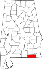 Map of Alabama highlighting Geneva County | |
| Towns | ||
| CDP | ||
| Unincorporated communities | ||
| Footnotes | ‡This populated place also has portions in an adjacent county or counties | |