Shakhdara Range
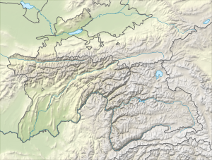
Shakhdara Range (Russian: Шахдаринский хребет) is a mountain range in Tajikistan, part of the Pamir Mountain System.
| Shakhdara Range Шахдаринский хребет | |
|---|---|
 Location in Tajikistan | |
| Highest point | |
| Peak | Karl Marx Peak |
| Elevation | 6,726 m (22,067 ft) |
| Coordinates | 37°10′N 72°0′E |
| Geography | |
| Country | Tajikistan |
| Parent range | Pamir Mountains |
| Geology | |
| Age of rock | Paleozoic |
| Type of rock | sedimentary and metamorphic rocks |
The range lies in the extreme south-western Pamir in Tajikistan's Gorno-Badakhshan Autonomous Province. It runs roughly in the east-west direction between the Shakhdara River to the north and Panj on the border with Afghanistan to the south, separating the watersheds of both rivers and rising toward Mayakovskiy Peak (6,096 m) in the west and Karl Marx Peak (6,726 m) in the east. Other high peaks of the range are Tajikistan Peak (6,565 m) and Engels Peak (6,510 m).[1]
The range takes its name (in both English and Russian) from the Shakhdara River, and is sometimes erroneously called Shakhdarin Range (or Shakhdarin Mountains), a corruption of the Russian name.
See also
- Roshtqal'a district
References
- Shakhdara Range - article from the Great Soviet Encyclopedia
| Districts | 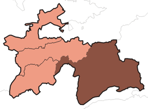 | |
|---|---|---|
| Main cities and towns | ||
| Geography |
| |