Selbu
Selbu is a municipality in Trøndelag county, Norway. The administrative centre of the municipality is the village of Mebonden. Other villages in Selbu include Flora, Fossan, Hyttbakken, Innbygda, Selbustrand, Trøa, Tømra, and Vikvarvet.
Selbu kommune | |
|---|---|
 View of Fongen from Baklifjell | |
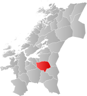
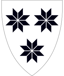 Coat of arms 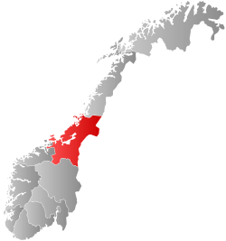 Trøndelag within Norway | |
 Selbu within Trøndelag | |
| Coordinates: 63°11′54″N 11°08′25″E | |
| Country | Norway |
| County | Trøndelag |
| District | Neadalen |
| Established | 1 Jan 1838 |
| Administrative centre | Mebonden |
| Government | |
| • Mayor (2015) | Ole Morten Balstad (Ap) |
| Area | |
| • Total | 1,234.85 km2 (476.78 sq mi) |
| • Land | 1,139.94 km2 (440.13 sq mi) |
| • Water | 94.91 km2 (36.64 sq mi) 7.7% |
| Area rank | 86 in Norway |
| Population (2020) | |
| • Total | 4,062 |
| • Rank | 200 in Norway |
| • Density | 3.6/km2 (9/sq mi) |
| • Change (10 years) | 1.4% |
| Demonym(s) | Selbygg[1] |
| Time zone | UTC+01:00 (CET) |
| • Summer (DST) | UTC+02:00 (CEST) |
| ISO 3166 code | NO-5032 |
| Official language form | Neutral[2] |
| Website | selbu |
The 1,235-square-kilometre (477 sq mi) municipality is the 86th largest by area out of the 356 municipalities in Norway. Selbu is the 200th most populous municipality in Norway with a population of 4,062. The municipality's population density is 3.6 inhabitants per square kilometre (9.3/sq mi) and its population has increased by 1.4% over the previous 10-year period.[3][4]
General information
The municipality (originally the parish) of Selbu was established on 1 January 1838 (see formannskapsdistrikt). On 1 January 1901, the eastern part of the municipality was separated to form the new municipality of Tydal. This left Selbu with 4,607 inhabitants. The borders of Selbu have not changed since that date.[5] On 1 January 2018, the municipality switched from the old Sør-Trøndelag county to the new Trøndelag county.
Name
The Old Norse form of the name was Selabú. The first element is the genitive case of the old name of the lake Selbusjøen (Old Norse: Seli). The last element is bú which means "district". (The old name of the lake is probably derived from the word seli which means "harness" since the lake is long and narrow.)[6]
Coat of arms
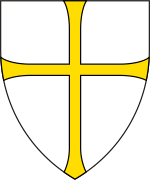
The coat of arms was adopted on 31 May 1991. The arms show a silver background with three black selburoses, designs which are typical for the patterns used in the local lusekofte (traditional Norwegian sweaters) and other woollen garments. Home knitting has been a long tradition in the municipality.[7]
Churches
The Church of Norway has one parish (sokn) within the municipality of Selbu. It is part of the Stjørdal prosti (deanery) in the Diocese of Nidaros.
| Parish (sokn) | Church Name | Location of the Church | Year Built |
|---|---|---|---|
| Selbu | Selbu Church | Mebonden | 1150 |
| Selbustrand Church | Selbustrand | 1901 | |
| Flora Chapel | Flora | 1936 |
Government
All municipalities in Norway, including Selbu, are responsible for primary education (through 10th grade), outpatient health services, senior citizen services, unemployment and other social services, zoning, economic development, and municipal roads. The municipality is governed by a municipal council of elected representatives, which in turn elect a mayor.[8] The municipality falls under the Sør-Trøndelag District Court and the Frostating Court of Appeal.
Municipal council
The municipal council (Kommunestyre) of Selbu is made up of 25 representatives that are elected to four year terms. The party breakdown of the council is as follows:
| Party Name (in Norwegian) | Number of representatives | |
|---|---|---|
| Labour Party (Arbeiderpartiet) | 13 | |
| Centre Party (Senterpartiet) | 7 | |
| Socialist Left Party (Sosialistisk Venstreparti) | 2 | |
| Joint list of the Conservative Party (Høyre) and Christian Democratic Party (Kristelig Folkeparti) | 3 | |
| Total number of members: | 25 | |
| Party Name (in Norwegian) | Number of representatives | |
|---|---|---|
| Labour Party (Arbeiderpartiet) | 10 | |
| Green Party (Miljøpartiet De Grønne) | 1 | |
| Conservative Party (Høyre) | 4 | |
| Socialist Left Party (Sosialistisk Venstreparti) | 2 | |
| Joint list of the Centre Party (Senterpartiet), Christian Democratic Party (Kristelig Folkeparti), and Liberal Party (Venstre) | 8 | |
| Total number of members: | 25 | |
| Party Name (in Norwegian) | Number of representatives | |
|---|---|---|
| Progress Party (Fremskrittspartiet) | 3 | |
| Conservative Party (Høyre) | 4 | |
| Joint list of the Labour Party (Arbeiderpartiet) and the Socialist Left Party (Sosialistisk Venstreparti) | 12 | |
| Joint list of the Centre Party (Senterpartiet), Christian Democratic Party (Kristelig Folkeparti), and Liberal Party (Venstre) | 6 | |
| Total number of members: | 25 | |
| Party Name (in Norwegian) | Number of representatives | |
|---|---|---|
| Progress Party (Fremskrittspartiet) | 3 | |
| Conservative Party (Høyre) | 3 | |
| Joint list of the Labour Party (Arbeiderpartiet) and the Socialist Left Party (Sosialistisk Venstreparti) | 11 | |
| Joint list of the Centre Party (Senterpartiet), Christian Democratic Party (Kristelig Folkeparti), and Liberal Party (Venstre) | 8 | |
| Total number of members: | 25 | |
| Party Name (in Norwegian) | Number of representatives | |
|---|---|---|
| Labour Party (Arbeiderpartiet) | 8 | |
| Progress Party (Fremskrittspartiet) | 3 | |
| Conservative Party (Høyre) | 3 | |
| Joint list of the Socialist Left Party and independent socialists (Fellesliste av Sosialistisk venstreparti og uavhengige sosialister) | 3 | |
| Joint list of the Centre Party (Senterpartiet), Christian Democratic Party (Kristelig Folkeparti), and Liberal Party (Venstre) | 8 | |
| Total number of members: | 25 | |
| Party Name (in Norwegian) | Number of representatives | |
|---|---|---|
| Labour Party (Arbeiderpartiet) | 10 | |
| Progress Party (Fremskrittspartiet) | 2 | |
| Joint list of the Socialist Left Party and independent socialists (Fellesliste av Sosialistisk venstreparti og uavhengige sosialister) | 2 | |
| Joint list of the Conservative Party (Høyre), Christian Democratic Party (Kristelig Folkeparti), Centre Party (Senterpartiet), and Liberal Party (Venstre) | 11 | |
| Total number of members: | 25 | |
| Party Name (in Norwegian) | Number of representatives | |
|---|---|---|
| Labour Party (Arbeiderpartiet) | 10 | |
| Conservative Party (Høyre) | 3 | |
| Liberal Party (Venstre) | 1 | |
| Joint list of the Socialist Left Party and independent socialists (Fellesliste av Sosialistisk venstreparti og uavhengige sosialister) | 3 | |
| Joint list of the Centre Party (Senterpartiet) and the Christian Democratic Party (Kristelig Folkeparti) | 8 | |
| Total number of members: | 25 | |
| Party Name (in Norwegian) | Number of representatives | |
|---|---|---|
| Labour Party (Arbeiderpartiet) | 10 | |
| Conservative Party (Høyre) | 3 | |
| Christian Democratic Party (Kristelig Folkeparti) | 1 | |
| Centre Party (Senterpartiet) | 6 | |
| Liberal Party (Venstre) | 1 | |
| Joint list of the Socialist Left Party and independent socialists (Fellesliste av Sosialistisk venstreparti og uavhengige sosialister) | 4 | |
| Total number of members: | 25 | |
| Party Name (in Norwegian) | Number of representatives | |
|---|---|---|
| Labour Party (Arbeiderpartiet) | 13 | |
| Conservative Party (Høyre) | 4 | |
| Christian Democratic Party (Kristelig Folkeparti) | 1 | |
| Centre Party (Senterpartiet) | 4 | |
| Liberal Party (Venstre) | 1 | |
| Joint list of the Socialist Left Party, Communist Party, and independent socialists (Fellesliste av Sosialistisk venstreparti, Norges kommunistisk parti og uavhengige sosialister) | 2 | |
| Total number of members: | 25 | |
| Party Name (in Norwegian) | Number of representatives | |
|---|---|---|
| Labour Party (Arbeiderpartiet) | 12 | |
| Conservative Party (Høyre) | 4 | |
| Joint list of the Centre Party (Senterpartiet), Christian Democratic Party (Kristelig Folkeparti), Liberal People's Party (Liberale Folkepartiet), and Liberal Party (Venstre) | 7 | |
| Joint list of the Socialist Left Party (Sosialistisk Venstreparti) and the Communist Party (Kommunistiske Parti) | 2 | |
| Total number of members: | 25 | |
| Party Name (in Norwegian) | Number of representatives | |
|---|---|---|
| Labour Party (Arbeiderpartiet) | 10 | |
| Joint list of the Conservative Party (Høyre), Christian Democratic Party (Kristelig Folkeparti), Liberal People's Party (Liberale Folkepartiet), Centre Party (Senterpartiet), and Liberal Party (Venstre) | 13 | |
| Joint list of the Socialist Left Party (Sosialistisk Venstreparti) and the Communist Party (Kommunistiske Parti) | 2 | |
| Total number of members: | 25 | |
| Party Name (in Norwegian) | Number of representatives | |
|---|---|---|
| Labour Party (Arbeiderpartiet) | 9 | |
| Socialist Left Party (Sosialistisk Venstreparti) | 3 | |
| Joint list of the Conservative Party (Høyre), Christian Democratic Party (Kristelig Folkeparti), New People's Party (Nye Folkepartiet), Centre Party (Senterpartiet), and Liberal Party (Venstre) | 13 | |
| Total number of members: | 25 | |
| Party Name (in Norwegian) | Number of representatives | |
|---|---|---|
| Labour Party (Arbeiderpartiet) | 11 | |
| Conservative Party (Høyre) | 2 | |
| Christian Democratic Party (Kristelig Folkeparti) | 2 | |
| Centre Party (Senterpartiet) | 6 | |
| Liberal Party (Venstre) | 2 | |
| Socialist common list (Venstresosialistiske felleslister) | 2 | |
| Total number of members: | 25 | |
| Party Name (in Norwegian) | Number of representatives | |
|---|---|---|
| Labour Party (Arbeiderpartiet) | 12 | |
| Conservative Party (Høyre) | 2 | |
| Communist Party (Kommunistiske Parti) | 1 | |
| Christian Democratic Party (Kristelig Folkeparti) | 2 | |
| Centre Party (Senterpartiet) | 5 | |
| Socialist People's Party (Sosialistisk Folkeparti) | 1 | |
| Liberal Party (Venstre) | 2 | |
| Total number of members: | 25 | |
| Party Name (in Norwegian) | Number of representatives | |
|---|---|---|
| Labour Party (Arbeiderpartiet) | 11 | |
| Conservative Party (Høyre) | 2 | |
| Communist Party (Kommunistiske Parti) | 2 | |
| Christian Democratic Party (Kristelig Folkeparti) | 2 | |
| Centre Party (Senterpartiet) | 6 | |
| Liberal Party (Venstre) | 2 | |
| Total number of members: | 25 | |
| Party Name (in Norwegian) | Number of representatives | |
|---|---|---|
| Labour Party (Arbeiderpartiet) | 12 | |
| Conservative Party (Høyre) | 1 | |
| Communist Party (Kommunistiske Parti) | 2 | |
| Christian Democratic Party (Kristelig Folkeparti) | 2 | |
| Centre Party (Senterpartiet) | 6 | |
| Liberal Party (Venstre) | 2 | |
| Total number of members: | 25 | |
| Party Name (in Norwegian) | Number of representatives | |
|---|---|---|
| Labour Party (Arbeiderpartiet) | 11 | |
| Conservative Party (Høyre) | 1 | |
| Communist Party (Kommunistiske Parti) | 3 | |
| Christian Democratic Party (Kristelig Folkeparti) | 2 | |
| Farmers' Party (Bondepartiet) | 5 | |
| Liberal Party (Venstre) | 3 | |
| Total number of members: | 25 | |
| Party Name (in Norwegian) | Number of representatives | |
|---|---|---|
| Labour Party (Arbeiderpartiet) | 10 | |
| Conservative Party (Høyre) | 1 | |
| Communist Party (Kommunistiske Parti) | 3 | |
| Christian Democratic Party (Kristelig Folkeparti) | 2 | |
| Farmers' Party (Bondepartiet) | 5 | |
| Liberal Party (Venstre) | 3 | |
| Total number of members: | 24 | |
| Party Name (in Norwegian) | Number of representatives | |
|---|---|---|
| Labour Party (Arbeiderpartiet) | 10 | |
| Communist Party (Kommunistiske Parti) | 4 | |
| Christian Democratic Party (Kristelig Folkeparti) | 2 | |
| Farmers' Party (Bondepartiet) | 5 | |
| Liberal Party (Venstre) | 3 | |
| Total number of members: | 24 | |
| Party Name (in Norwegian) | Number of representatives | |
|---|---|---|
| Labour Party (Arbeiderpartiet) | 13 | |
| Farmers' Party (Bondepartiet) | 6 | |
| Liberal Party (Venstre) | 5 | |
| Total number of members: | 24 | |
Geography
Selbu borders nine municipalities. The municipalities of Trondheim, Malvik, and Stjørdal are to the north; Meråker and Tydal are to the east; Tydal, Holtålen, and Midtre Gauldal are to the south; and Melhus and Klæbu are to the west.
The largest lake in Selbu is Selbusjøen with an area of about 60 square kilometres (23 sq mi). It is located 160 metres (520 ft) above sea level. Another lake in the municipality is Sørungen. The highest mountain in Selbu is the 1,441-metre (4,728 ft) tall mountain Fongen, located inside Skarvan and Roltdalen National Park. The Nea River and Rotla River both flow through the municipality. The municipality covers a total of 1,254 square kilometres (484 sq mi) which consists of:
| Land type | Area | ||
|---|---|---|---|
| square kilometres | square miles | percentage | |
| Freshwater lakes[note 1] and rivers | 85 | 33 | 6.8 |
| Agriculture | 31 | 12 | 2.5 |
| Woodlands | 308 | 119 | 14.7 |
| Swampland and mountains | 830 | 320 | 66.0 |
Note:
| |||
Transportation
The main road through Selbu is Norwegian County Road 705 that runs between Stjørdal, Selbu, and Tydal. Selbu is located near important destinations:
| Destination | Distance | |
|---|---|---|
| kilometres | miles | |
| Stjørdalshalsen | 45 | 28 |
| Trondheim Airport, Værnes | 40 | 25 |
| Trondheim | 70 | 43 |
| Ås (Tydal) | 45 | 28 |
| Røros | 120 | 75 |
Economy
Traditionally, Selbu has been an agricultural and forest managing community. The area is well known for its special knitting techniques. The last decades have led to efforts in business such as high technology, electronics, and mechanics. The newspaper Selbyggen has been published in Selbu since 1889.[27]
References
- "Navn på steder og personer: Innbyggjarnamn" (in Norwegian). Språkrådet.
- "Forskrift om målvedtak i kommunar og fylkeskommunar" (in Norwegian). Lovdata.no.
- Statistisk sentralbyrå (2020). "Table: 06913: Population 1 January and population changes during the calendar year (M)" (in Norwegian).
- Statistisk sentralbyrå (2020). "09280: Area of land and fresh water (km²) (M)" (in Norwegian).
- Statistisk sentralbyrå (1 January 2009). "Urban settlements. Population and area, by municipality".
- Rygh, Oluf (1901). Norske gaardnavne: Søndre Trondhjems amt (in Norwegian) (14 ed.). Kristiania, Norge: W. C. Fabritius & sønners bogtrikkeri. p. 376.
- "Civic heraldry of Norway - Norske Kommunevåpen". Heraldry of the World. Retrieved 2018-03-11.
- Hansen, Tore, ed. (2016-05-12). "kommunestyre". Store norske leksikon (in Norwegian). Kunnskapsforlaget. Retrieved 2019-01-01.
- "Tall for Norge: Kommunestyrevalg 2019 - Trøndelag". Valg Direktoratet. Retrieved 2019-10-20.
- "Table: 04813: Members of the local councils, by party/electoral list at the Municipal Council election (M)" (in Norwegian). Statistics Norway.
- "Tall for Norge: Kommunestyrevalg 2011 - Sør-Trøndelag". Valg Direktoratet. Retrieved 2019-10-20.
- "Kommunestyrevalget 1995" (PDF) (in Norwegian). Oslo-Kongsvinger: Statistisk sentralbyrå. 1996. Retrieved 2020-06-23.
- "Kommunestyrevalget 1991" (PDF) (in Norwegian). Oslo-Kongsvinger: Statistisk sentralbyrå. 1993. Retrieved 2020-06-23.
- "Kommunestyrevalget 1987" (PDF) (in Norwegian). Oslo-Kongsvinger: Statistisk sentralbyrå. 1988. Retrieved 2020-06-23.
- "Kommunestyrevalget 1983" (PDF) (in Norwegian). Oslo-Kongsvinger: Statistisk sentralbyrå. 1984. Retrieved 2020-06-23.
- "Kommunestyrevalget 1979" (PDF) (in Norwegian). Oslo: Statistisk sentralbyrå. 1979. Retrieved 2020-06-23.
- "Kommunevalgene 1975" (PDF) (in Norwegian). Oslo: Statistisk sentralbyrå. 1977. Retrieved 2020-06-23.
- "Kommunevalgene 1972" (PDF) (in Norwegian). Oslo: Statistisk sentralbyrå. 1973. Retrieved 2020-06-23.
- "Kommunevalgene 1967" (PDF) (in Norwegian). Oslo: Statistisk sentralbyrå. 1967. Retrieved 2020-06-23.
- "Kommunevalgene 1963" (PDF) (in Norwegian). Oslo: Statistisk sentralbyrå. 1964. Retrieved 2020-06-23.
- "Kommunevalgene og Ordførervalgene 1959" (PDF) (in Norwegian). Oslo: Statistisk sentralbyrå. 1960. Retrieved 2020-06-23.
- "Kommunevalgene og Ordførervalgene 1955" (PDF) (in Norwegian). Oslo: Statistisk sentralbyrå. 1957. Retrieved 2020-06-23.
- "Kommunevalgene og Ordførervalgene 1951" (PDF) (in Norwegian). Oslo: Statistisk sentralbyrå. 1952. Retrieved 2020-06-23.
- "Kommunevalgene og Ordførervalgene 1947" (PDF) (in Norwegian). Oslo: Statistisk sentralbyrå. 1948. Retrieved 2020-06-23.
- "Kommunevalgene og Ordførervalgene 1945" (PDF) (in Norwegian). Oslo: Statistisk sentralbyrå. 1947. Retrieved 2020-06-23.
- "Kommunevalgene og Ordførervalgene 1937" (PDF) (in Norwegian). Oslo: Statistisk sentralbyrå. 1938. Retrieved 2020-06-23.
- Breivik Pettersen, Øyvind, ed. (2017-02-17). "Selbyggen". Store norske leksikon (in Norwegian). Kunnskapsforlaget. Retrieved 2018-03-11.
External links
| Wikimedia Commons has media related to Selbu. |

- Municipal fact sheet from Statistics Norway (in Norwegian)
- Aerial photography from Selbu
- Selbuvott
 |
|  | |||||||||||||||||||||||
||
| Authority control |
|
|---|