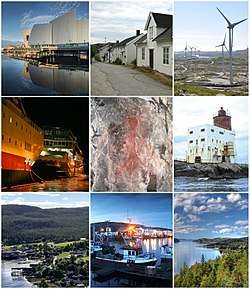
Nærøysund
Nærøysund is a municipality in Trøndelag county, Norway. It is located in the traditional district of Namdalen. The municipality was established on 1 January 2020 after the merger of the old municipalities of Vikna and Nærøy. The municipality is unique in that it has two equal administrative centre: Kolvereid and Rørvik.[3] The other main population centres of Nærøysund include Abelvær, Foldereid, Gravvik, Lund, Ottersøy, Salsbruket, Steine, Torstad, Austafjord, Garstad, and Valøya.
Nærøysund kommune | |
|---|---|
 | |
 Coat of arms 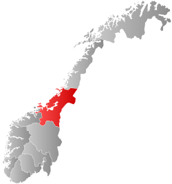 Trøndelag within Norway | |
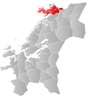 Nærøysund within Trøndelag | |
| Coordinates: 64.8393°N 11.4608°E | |
| Country | Norway |
| County | Trøndelag |
| District | Namdalen |
| Established | 1 Jan 2020 |
| Administrative centre | Kolvereid and Rørvik |
| Government | |
| • Mayor (2020) | Amund Hellesø (Ap) |
| Area | |
| • Total | 1,346.16 km2 (519.76 sq mi) |
| • Land | 1,286.31 km2 (496.65 sq mi) |
| • Water | 59.85 km2 (23.11 sq mi) 4.4% |
| Area rank | 70 in Norway |
| Population (2020) | |
| • Total | 9,623 |
| • Rank | 116 in Norway |
| • Density | 7.5/km2 (19/sq mi) |
| • Change (10 years) | 5.6% |
| Demonym(s) | nærøyværing viknaværing[1] |
| Time zone | UTC+01:00 (CET) |
| • Summer (DST) | UTC+02:00 (CEST) |
| ISO 3166 code | NO-5060 |
| Official language form | Neutral[2] |
| Website | naroysund |
The 1,346-square-kilometre (520 sq mi) municipality is the 70th largest by area out of the 356 municipalities in Norway. Nærøysund is the 116th most populous municipality in Norway with a population of 9,623. The municipality's population density is 7.5 inhabitants per square kilometre (19/sq mi) and its population has increased by 5.6% over the previous 10-year period.[4][5]
General information
Municipal history
The municipality was established on 1 January 2020 when the neighboring municipalities of Nærøy and Vikna were merged. The small Lund area of Nærøy was not part of the merger, it instead was merged with the large Namsos Municipality to the south on the same date. The merger came about because on 8 June 2017, the Norwegian Parliament, the Storting, voted to merge the municipalities of Leka, Vikna, Nærøy, and Bindal to form one, large municipality effective 1 January 2020.[6] Leka and Bindal municipalities rejected the merger, but Vikna and Nærøy agreed to the merger so it was carried out in 2020.[7]
Name
The name comes from the Nærøysundet strait. The strait is named after the nearby island Nærøya. The Old Norse form of the name of the island was Njarðøy. The first element is maybe the stem form of the name of the Norse god Njord (but it is suspicious that it is not in the genitive case). The last element is øy which means "island". Historically, the name has had varying spellings such as Nærø or Nærøen.[8][9]
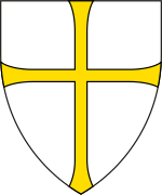
Coat of arms
The coat of arms for the municipality was approved in 2019. The arms are a white shield with a green and blue intertwined design. The green symbolizes the land and agriculture while the blue symbolizes the sea and fishing industry. Both are intertwined like a rope to symbolize unity and the two old municipalities becoming one.[10][11]
Churches
The Church of Norway had two parishes (sokn) within the municipality of Nærøy. It is part of the Namdal prosti (deanery) in the Diocese of Nidaros.
| Parish (sokn) | Church Name | Location of the Church | Year Built |
|---|---|---|---|
| Nærøy | Foldereid Church | Foldereid | 1863 |
| Gravvik Church | Gravvik | 1875 | |
| Kolvereid Church | Kolvereid | 1874 | |
| Lundring Church | Lundring | 1885 | |
| Salsbruket Chapel | Salsbruket | 1950 | |
| Steine Chapel | Steine | 1911 | |
| Torstad Chapel | Torstad | 1936 | |
| Vikna | Garstad Church | Garstad | 1856 |
| Rørvik Church | Rørvik | 1896 | |
| Valøy Chapel | Valøya | 1972 |
Government
All municipalities in Norway, including Nærøysund, are responsible for primary education (through 10th grade), outpatient health services, senior citizen services, unemployment and other social services, zoning, economic development, and municipal roads. The municipality is governed by a municipal council of elected representatives, which in turn elects a mayor.[12] The municipality falls under the Namdal District Court and the Frostating Court of Appeal.
Municipal council
The municipal council (Kommunestyre) of Nærøysund is made up of 37 representatives that are elected to four year terms. The party breakdown of the council is as follows:
| Party Name (in Norwegian) | Number of representatives | |
|---|---|---|
| Labour Party (Arbeiderpartiet) | 14 | |
| Progress Party (Fremskrittspartiet) | 4 | |
| Green Party (Miljøpartiet De Grønne) | 1 | |
| Conservative Party (Høyre) | 5 | |
| Christian Democratic Party (Kristelig Folkeparti) | 1 | |
| Centre Party (Senterpartiet) | 9 | |
| Socialist Left Party (Sosialistisk Venstreparti) | 1 | |
| Liberal Party (Venstre) | 2 | |
| Total number of members: | 37 | |
References
- "Navn på steder og personer: Innbyggjarnamn" (in Norwegian). Språkrådet.
- "Forskrift om målvedtak i kommunar og fylkeskommunar" (in Norwegian). Lovdata.no.
- Rosvold, Knut A., ed. (2020-01-20). "Nærøysund". Store norske leksikon (in Norwegian). Kunnskapsforlaget. Retrieved 2020-04-10.
- Statistisk sentralbyrå (2020). "Table: 06913: Population 1 January and population changes during the calendar year (M)" (in Norwegian).
- Statistisk sentralbyrå (2020). "09280: Area of land and fresh water (km²) (M)" (in Norwegian).
- "Kommunesammenslåing Nærøy, Vikna, Leka, og Bindal" (PDF) (in Norwegian). Leka kommune. 2017-08-21. Retrieved 2017-09-26.
- "Navn på ny kommune" (in Norwegian). Vikna kommune. 2018-02-05. Archived from the original on 2018-04-30. Retrieved 2018-04-29.
- Store norske leksikon. "Nærøy – Nord-Trøndelag" (in Norwegian). Retrieved 2011-10-03.
- Rygh, Oluf (1903). Norske gaardnavne: Nordre Trondhjems amt (dokpro.uio.no) (in Norwegian) (15 ed.). Kristiania, Norge: W. C. Fabritius & sønners bogtrikkeri. p. 354.
- "Slik blir Nærøysunds kommunevåpen". Namdals Avisa (in Norwegian). Retrieved 2019-12-30.
- "Dette er de to forslagene til kommunevåpen som politikerne i Nærøy og Vikna får forelagt" (in Norwegian). Ytringen.no. Retrieved 2019-12-30.
- Hansen, Tore, ed. (2016-05-12). "kommunestyre". Store norske leksikon (in Norwegian). Kunnskapsforlaget. Retrieved 2019-10-20.
- "Tall for Norge: Kommunestyrevalg 2019 - Trøndelag". Valg Direktoratet. Retrieved 2019-10-19.
 |
|  | |||||||||||||||||||||||
||