Saint-Martin-de-Brômes
Saint-Martin-de-Brômes is a commune in the Alpes-de-Haute-Provence department in southeastern France.
Saint-Martin-de-Brômes | |
|---|---|
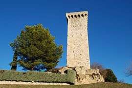 Clock tower | |
 Coat of arms | |
Location of Saint-Martin-de-Brômes 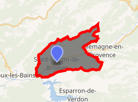
| |
 Saint-Martin-de-Brômes  Saint-Martin-de-Brômes | |
| Coordinates: 43°46′15″N 5°56′46″E | |
| Country | France |
| Region | Provence-Alpes-Côte d'Azur |
| Department | Alpes-de-Haute-Provence |
| Arrondissement | Forcalquier |
| Canton | Valensole |
| Intercommunality | Luberon Durance Verdon |
| Government | |
| • Mayor (2008–2014) | Jean-Christophe Petrigny |
| Area 1 | 21.09 km2 (8.14 sq mi) |
| Population (2017-01-01)[1] | 590 |
| • Density | 28/km2 (72/sq mi) |
| Time zone | UTC+01:00 (CET) |
| • Summer (DST) | UTC+02:00 (CEST) |
| INSEE/Postal code | 04189 /04800 |
| Elevation | 307–588 m (1,007–1,929 ft) |
| 1 French Land Register data, which excludes lakes, ponds, glaciers > 1 km2 (0.386 sq mi or 247 acres) and river estuaries. | |
Population
| Year | Pop. | ±% |
|---|---|---|
| 1765 | 418 | — |
| 1793 | 499 | +19.4% |
| 1806 | 511 | +2.4% |
| 1821 | 501 | −2.0% |
| 1831 | 541 | +8.0% |
| 1836 | 540 | −0.2% |
| 1841 | 500 | −7.4% |
| 1846 | 526 | +5.2% |
| 1851 | 507 | −3.6% |
| 1856 | 501 | −1.2% |
| 1861 | 476 | −5.0% |
| 1866 | 463 | −2.7% |
| 1872 | 449 | −3.0% |
| 1876 | 454 | +1.1% |
| 1881 | 431 | −5.1% |
| 1886 | 403 | −6.5% |
| 1891 | 392 | −2.7% |
| 1896 | 406 | +3.6% |
| 1901 | 391 | −3.7% |
| 1906 | 417 | +6.6% |
| 1911 | 334 | −19.9% |
| 1921 | 264 | −21.0% |
| 1926 | 271 | +2.7% |
| 1931 | 245 | −9.6% |
| 1936 | 202 | −17.6% |
| 1946 | 229 | +13.4% |
| 1954 | 184 | −19.7% |
| 1962 | 167 | −9.2% |
| 1968 | 222 | +32.9% |
| 1975 | 217 | −2.3% |
| 1982 | 244 | +12.4% |
| 1990 | 339 | +38.9% |
| 1999 | 403 | +18.9% |
| 2008 | 512 | +27.0% |
References
- "Populations légales 2017". INSEE. Retrieved 6 January 2020.
| Wikimedia Commons has media related to Saint-Martin-de-Brômes. |
| Authority control |
|
|---|
This article is issued from Wikipedia. The text is licensed under Creative Commons - Attribution - Sharealike. Additional terms may apply for the media files.