Archail
Archail is a commune in the Alpes-de-Haute-Provence department in the Provence-Alpes-Côte d'Azur region of south-eastern France.
Archail | |
|---|---|
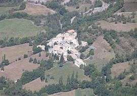 The village | |
Location of Archail 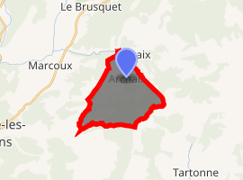
| |
 Archail  Archail | |
| Coordinates: 44°07′20″N 6°20′06″E | |
| Country | France |
| Region | Provence-Alpes-Côte d'Azur |
| Department | Alpes-de-Haute-Provence |
| Arrondissement | Digne-les-Bains |
| Canton | Seyne |
| Intercommunality | Provence-Alpes Agglomération |
| Government | |
| • Mayor (2015-2020) | Laurence Guichard-Sagnez |
| Area 1 | 12.99 km2 (5.02 sq mi) |
| Population (2017-01-01)[1] | 15 |
| • Density | 1.2/km2 (3.0/sq mi) |
| Time zone | UTC+01:00 (CET) |
| • Summer (DST) | UTC+02:00 (CEST) |
| INSEE/Postal code | 04009 /04420 |
| Elevation | 759–1,984 m (2,490–6,509 ft) (avg. 920 m or 3,020 ft) |
| 1 French Land Register data, which excludes lakes, ponds, glaciers > 1 km2 (0.386 sq mi or 247 acres) and river estuaries. | |
It is the second least populated commune in the department.
The inhabitants of the commune are known as Archailois or Archailoises.[2]
Geography
Archail is located some 8 km north-east of Digne and some 5 km south of Le Brusquet. By road from Digne it is 14 km by a winding mountain road. The village is located in a wooded basin at an altitude of 920m.[3] Access to the commune is by the D22 road which runs east from Marcoux to Draix and which passes through the northern tip of the commune. A local road runs off the D22 in the northern tip of the commune and continues south through the commune to the village. The commune is mountainous and heavily forested but there is a small area of farmland south-west of the village.[4]
Geology
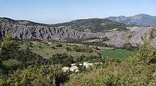
Much of the commune consists of rounded hills of eroded black marl. The Pic de Couar (1,988m) is spectacular as is the Pas d'Archail (1,667m). The Ravine and Torrent of l'Areste is in the south in the hills.
Hydrology
A vast number of streams rise in the commune including: The Bouinenc[5] (13.8 kilometres long), the Sauzeries Ravine[6] (9 km long), the Mouiroués Ravine[7] (8 km long), and its tributary, the Escure Stream[8] (5.7 km long). These all flow north to join the Bouinenc which continues west to join the Bléone.[4]
Natural and technological hazards
None of the 200 communes of the department is in a no seismic risk zone. The Canton of La Javie to which Archail belongs is in Zone 1b (low risk) according to the deterministic classification of 1991 and based on its seismic history. The Canton is in Zone 4 (medium risk) according to the probabilistic classification EC8 2011.[9] The commune of Archail is also exposed to two other natural hazards:[9] forest fire and landslide.
Neighbouring communes and villages
Places adjacent to Archail | ||||||||||
|---|---|---|---|---|---|---|---|---|---|---|
| ||||||||||
Toponymy
The area appears for the first time in texts around 1200 in the form Archallo. The origin of the name is Celtic-Ligurian and means in front of the rocks.[10] The Historical Atlas of Provence also indicates a spelling of Arcalhum.[11]
History
In Antiquity the Bodiontiques (Bodiontici) inhabited the Bléone valley and so were the Gallic people who lived in what is now the commune of Archail. The Bodiontiques were defeated by Augustus at the same time as the other people present on the Tropaeum Alpium (before 14 BC) and were attached to the province of Alpes-Maritimes during its creation.[12]
According to Daniel Thiery, the community was reported in the Polyptych of Wadalde (Bishop of Marseille) in 814 under the name Argario.[13]
The community of Archail was under the Viguerie of Digne.[13] In 1193 the lordship of Archail (Argal) was given by the two lords of Saint-Julien to the Chapter of Digne.[13] The lordship was divided between the Bishops of Digne and the Chapter of Digne before the French Revolution.[11] These new lords strengthened their new possession and collected the population in a central location.[13]
As with many of the communes in the department, Archail had a school well before the Jules Ferry laws: in 1863 it already had a school that provided primary education for boys in the main town.[14] No instruction was given to girls: neither the Falloux Laws (1851), which required the opening of a girls' school in communes with more than 800 inhabitants,[15] nor the first Duruy Law (1867), which lowered the threshold to 500 inhabitants, related to Archail[16] and it was only through the Ferry laws that Archail girls were able to regularly study.
Between 1973 and 1979 the commune was merged with Draix under the name Archail-Draix.[17][18]
Administration
List of successive mayors:[19]
| From | To | Name | Party | Position |
|---|---|---|---|---|
| 1945 | Jean-Baptiste Giraud[20] | |||
| 1946 | 2001 | Jean Paul Ferrary[21] | ||
| 2001 | 2015 | Maurice Ferrary | DVD | |
| 2015 | Current | Laurence Guichard-Sagnez |
(Not all data is known.)
Population
| Year | Pop. | ±% |
|---|---|---|
| 2005 | 8 | — |
| 2006 | 8 | +0.0% |
| 2007 | 7 | −12.5% |
| 2008 | 11 | +57.1% |
| 2009 | 14 | +27.3% |
| 2010 | 17 | +21.4% |
| 2011 | 20 | +17.6% |
| 2012 | 23 | +15.0% |
| 2013 | 20 | −13.0% |
| 2014 | 18 | −10.0% |
| 2015 | 16 | −11.1% |
| 2016 | 15 | −6.2% |
Economy
Overview
In 2009, the active population was 7 people with no unemployed.[22] 6 out of 7 of these workers were employees[23] and worked outside the commune.
As at 1 January 2011 the commune had only four active establishments: one in the construction sector, and three in the services sector, which offered the only job in the commune.[24]
Agriculture
At the end of 2010 there was no commercial operation in the primary sector (agriculture, forestry, fisheries).[24][25] There are nevertheless artificial meadows irrigated from the irrigation reservoir above the village at the foot of the Pic du Couar which was dug in the 1980s under the leadership of the mayor and the sheep farmer.
Service activities
At the end of 2010 the tertiary sector (trade, service) consisted of three establishments with one job.[24]
According to the Departmental Observatory of Tourism, tourism is very important for the community, with more than five tourists welcomed per resident.[26] Most of the accommodation capacity is non-market[27] and is composed solely of secondary homes:[28] 18 secondary homes are three quarters of the commune housing.[29]
Sites and monuments
- Old houses in beautiful condition.
- The Parish Church of Our Lady of the Assumption and Saint George[13] was built in 1828.[30] Its origin can be traced back to the 13th century.[13] The church contains many items that are registered as historical objects:
- A Processional Banner (19th century)

- A Painting: Saint Charles Borromée (1842)
- A Statue: Saint Charles Borromée (19th century)
- A Painting: Donation of the Rosary (19th century)
- A Thurible (18th century)
- A Monstrance (19th century)
- A Statue: Saint Joseph (19th century)
- A Statue: The Coronation of the Virgin (19th century)
- A Processional Banner (19th century)
- The Notre Dame Chapel, situated on a hill in the middle of the cemetery, is the oldest parish church in the community: its foundation is older than the current village church.[13] Residents participated in the rebuilding of the chapel in 1994.[13] Until the Revolution and the Empire, this chapel was the focus of a pilgrimage in August, which attracted people in surrounding communities, and which ended with games and a ball.[13]
Cultural life
The association Les Ateliers du Couar hosts May Art every year in May with many artists-exhibitors (ceramics, paintings, sculptors, photographers) and various other events related to images in all their forms and in association with many artistic expressions (literature, poetry, cinema, theatre, etc.). The theme is rural and historical heritage and messages are conveyed through various modes such as the creation of an artist's book on transhumance.
This association publishes Les Cahiers du Couar with four numbers:
- "Banaste of words and images for a summer pasture. Transhumance 2005 at the foot of White Horse"
- the Robines
- In September 2008: the Couar Workbook No. 3 on "Water"
- In October 2009: the Couar Workbook No. 4 on honey and lavender
Notable people linked to the commune
- Jean-Pierre Alexandre Dieudé (1743-1819), born in Archail, general of the armies of the Republic and the Empire.
See also
Bibliography
- Raymond Collier: La Haute-Provence monumental and artistic, Digne, Jean Louis Printing, 1986, 559 p. (in French)
- Ed. Edward Baratier, Georges Duby, and Ernest Hildesheimer: Historical Atlas. Provence, County of Venaissin, Principality of Orange, County of Nice, Principality of Monaco, Librairie Armand Colin, Paris, 1969 (in French)
External links
- Ateliers du Couar website (in French)
- Archail on the National Geographic Institute website (in French)
- Archail on Lion1906
- Archail on Géoportail, National Geographic Institute (IGN) website (in French)
- Archail on the 1750 Cassini Map
Notes and references
Notes
References
- "Populations légales 2017". INSEE. Retrieved 6 January 2020.
- Inhabitants of Alpes-de-Haute-Provence (in French)
- Michel de La Torre, Alpes-de-Haute-Provence: The complete guide to 200 communes, Paris, Deslogis-Lacoste, coll. "Towns and Villages of France", 1989, Relié, 72 p. (non-paginated) (ISBN 2-7399-5004-7) (in French)
- Google Maps
- Bounenc page on the Sandre website (in French)
- Sauzeries page on the Sandre website (in French)
- Mouiroués Ravine page on the Sandre website (in French)
- The Escure page on the Sandre website (in French)
- Minister of Ecology, Sustainable Development, Transport, and Lodgings, Communal Notice Archived 2016-03-03 at the Wayback Machine on the Gaspar database, online 27 May 2011, consulted on 25 June 2012 (in French)
- Charles Rostaing, Essay on the Toponymy of Provence (since its origins to the barbarian invasions), Laffite Reprints, Marseille, 1973 (1st edition 1950), p 120 (in French)
- Ed. Edward Baratier, Georges Duby, and Ernest Hildesheimer: Historical Atlas. Provence, County of Venaissin, Principality of Orange, County of Nice, Principality of Monaco, Librairie Armand Colin, Paris, 1969, p. 160.
- Brigitte Beaujard, The cities of southern Gaul from the 3rd to the 7th centuries, Gallia, 63, 2006, CNRS éditions, p. 22 (in French)
- Daniel Thiery, Archail, On the origins of churches and rural chapels in Alpes-de-Haute-Provence, published 12 December 2010, online 15 December 2010, consulted on 25 June 2012 (in French)
- Jean-Christophe Labadie (director), Les Maisons d’école, Digne-les-Bains, Departmental archives of Alpes-de-Haute-Provence, 2013, ISBN 978-2-86-004-015-0, p. 9.
- Jean-Christophe Labadie (director), Les Maisons d’école, Digne-les-Bains, Departmental archives of Alpes-de-Haute-Provence, 2013, ISBN 978-2-86-004-015-0, p. 16.
- Jean-Christophe Labadie (director), Les Maisons d’école, Digne-les-Bains, Departmental archives of Alpes-de-Haute-Provence, 2013, ISBN 978-2-86-004-015-0, p. 18.
- EHESS, Communal Notice for Archail on the Cassini database, consulted on 22 July 2009 (in French)
- Ehess, Communal Notice for Draix on the Cassini database, consulted on 10 November 2009 (in French)
- List of Mayors of France
- Sébastien Thébault and Thérèse Dumont, The Liberation, Basses-Alpes 39-45, published 31 March 2014, consulted on 2 April 2014.
- Between 1973 and 1979 he was Mayor of Archail-Draix
- INSEE, Local Dossier - Commune : Archail (04009) Archived 2014-04-07 at the Wayback Machine, p. 5
- INSEE, Local Dossier, p. 7
- INSEE, Local Dossier, p. 16
- Minister of Agriculture, "Techno-Economic Orientation for Farming", Agricultural censuses 2010 and 2000. (Online: N.B. The page is 4.4 Mb)
- Departmental Observatory of Tourism, Atlas de l'hébergement touristique, December 2008, p. 6 (in French)
- Departmental Observatory of Tourism, Atlas de l'hébergement touristique, December 2008, p. 7 (in French)
- Departmental Observatory of Tourism, Atlas de l'hébergement touristique, December 2008, p. 44 (in French)
- Insee, Local Dossier, p. 16
- Raymond Collier: La Haute-Provence monumental and artistic, Digne, Jean Louis Printing, 1986, 559p, p. 379 (in French)
- Ministry of Culture, Palissy PM04002471 Processional Banner (in French)
- Ministry of Culture, Palissy PM04002470 Painting: Saint Charles Borromée (in French)
- Ministry of Culture, Palissy PM04002466 Statue: Saint Charles Borromée (in French)
- Ministry of Culture, Palissy PM04002469 Painting: Donation of the Rosary (in French)
- Ministry of Culture, Palissy PM04002468 Thurible (in French)
- Ministry of Culture, Palissy PM04002467 Monstrance (in French)
- Ministry of Culture, Palissy PM04002465 Statue: Saint Joseph (in French)
- Ministry of Culture, Palissy PM04002464 Statue: The Virgin (in French)
| Wikimedia Commons has media related to Archail. |