Rural Municipality of St. Andrews
St. Andrews is a rural municipality in Manitoba, Canada. It lies west Red River; its southern border is approximately 8 kilometres (5.0 mi) north of Winnipeg. The communities of Clandeboye, Petersfield, and Lockport (the part west of the Red River) are located in St. Andrews. The city of Selkirk, the town of Winnipeg Beach, and the village of Dunnottar are located adjacent to the municipality but are separate urban municipalities. St. Andrews is part of Manitoba census division 13.
St. Andrews | |
|---|---|
Rural Municipality | |
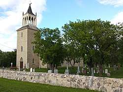 St. Andrews Anglican Church | |
 St. Andrews | |
| Coordinates: 50°16′12″N 96°58′29″W | |
| Country | |
| Province | |
| Region | Winnipeg Metro Region |
| Government | |
| • Mayor | Joy Sul |
| Area | |
| • Total | 752.22 km2 (290.43 sq mi) |
| Elevation | 223 m (732 ft) |
| Population (2016)[1] | |
| • Total | 11,913 |
| • Density | 16/km2 (41/sq mi) |
| Time zone | UTC−6 (CST) |
| • Summer (DST) | UTC−5 (CDT) |
| Postal Code | R0C 0P0 |
| Area codes | 204, 431 |
| Website | rmofstandrews |
History
Since the Red River was an important means of transportation in the early settlement and parish, much of St. Andrews' history can be seen along River Road. The parish of St. Andrews was situated between two major fur trading centers of the Hudson's Bay Company, Lower Fort Garry (near present-day Selkirk) and Upper Fort Garry (located in present-day Winnipeg).
The name St. Andrews was derived from the Anglican parish of St. Andrews, which existed for several decades prior to the formation of the municipality in February 1880.[3]
St. Andrews Anglican Church is one of the most well known historical sites. Built in 1849, it served a centre of Anglican missionary activity in Rupert's Land. It is the oldest surviving stone church in Western Canada and was designated a national historic site in 1970. Its distinctive steeple and Gothic Revival architecture make it instantly recognizable and the building is used as symbol for both the community as well as the nearby St. Andrews elementary school.
Captain William Kennedy House is located along the Red River about 200 m (660 ft) north of the St. Andrews church. Built in 1866 by Captain William Kennedy (1814–1890) it is now used as a museum and tea house. Its nearby flower garden is well known among locals and is commonly used for wedding photos. It was officially recognized as a provincial heritage site in 1984.[4]
Twin Oaks and Miss Davis' School Residence was a girls school and boarding house built in the 1850s by the Red River Settlement and the Hudson's Bay Company.[5] It became a National Historic site in 1962.
Points of interest
_(9444684850).jpg)
In addition to the St. Andrews church, the municipality contains many historical and significant buildings and establishments include the St. Andrews Rectory, Captain Kennedy House, Lower Fort Garry, River Road Heritage Parkway, St. Andrews Locks and Dam, Little Britain United Church and Cemetery, Twin Oaks, and St. John's Cathedral Boys' School in Breezy Point. These and several others have been officially recognized as national, provincial, or municipal historic sites. Other noteworthy establishments include the St. Andrews airport, St. Andrews school, the municipal office, Larter's golf course, River Road Provincial Park, and Oak Hammock Marsh (a nature preserve which lies partly in St. Andrews).
Notable people born in St. Andrews include Darren Helm, a professional ice hockey player for the Detroit Red Wings of the National Hockey League.
Communities
- Claneboye
- Less Crossing
- Little Britain
- Lockport (part)
- Netley
- Parkdale
- Petersfield
- St. Andrews
Water
The R.M. of St. Andrews receives its water supply from two underground carbonate aquifer wells. The water system is managed by the nearby City of Selkirk.[6]
| Year | Pop. | ±% |
|---|---|---|
| 1981 | 7,990 | — |
| 1986 | 8,755 | +9.6% |
| 1996 | 10,144 | +15.9% |
| 2001 | 10,695 | +5.4% |
| 2006 | 11,359 | +6.2% |
| 2011 | 11,875 | +4.5% |
| 2016 | 11,913 | +0.3% |
Governance
St. Andrews is a municipal government, led by a mayor and 6 councillors. Since 2012, the mayor of St. Andrews has come under some scrutiny for being the highest-paid mayor of the Winnipeg metro region.[7] The municipal office for St. Andrews is located in Clandeboye.
Gallery
.JPG) St. Andrews Lock and Dam
St. Andrews Lock and Dam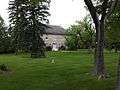 Twin Oaks and Miss Davis' School Residence on River Road.
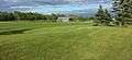 Larters Golf course
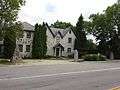 Captain William Kennedy House.
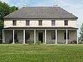 St. Andrews Rectory National Historic Site Manitoba Canada Front View
References
- "2016 Census Profile - RM of St. Andrews". statcan.gc.ca. November 29, 2017. Retrieved December 25, 2019.
- "Elevation at St. Andrews". earthtools.org.
- "Manitoba Municipalities: St. Andrews". The Manitoba Historical Society. Retrieved 19 October 2015.
- "Captain William Kennedy House". The Canadian Register of Historic Places. Retrieved 9 June 2016.
- "Miss Davis' School Residence / Twin Oaks National Historic Site of Canada". The Canadian Register of Historic Places. Retrieved 9 June 2016.
- "Public Water System Annual Report 2018" (PDF). City of Selkirk. April 1, 2019. p. 2.
- Bill Redekop (17 February 2015). "Salaries for municipal leaders in the capital region vary widely - Winnipeg Free Press". Winnipegfreepress.com. Retrieved October 29, 2015.
External links
| Wikimedia Commons has media related to St. Andrews, Manitoba. |
- RM of St. Andrews website
- Map of St. Andrews R.M. at Statcan
- Manitoba Historical Society - Rural Municipality of St. Andrews
Places adjacent to Rural Municipality of St. Andrews | |
|---|---|
| Cities | 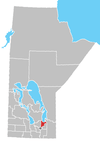 | |
|---|---|---|
| Villages | ||
| Rural municipalities | ||
| First Nations | ||
| Indian reserves | ||
| Unincorporated communities | ||