Rubha an Dùnain
Rubha an Dùnain or Rubh' an Dùnain (Scottish Gaelic pronunciation: [ᵲu(.ə) ən t̪uːnən]) is an uninhabited peninsula to the south of the Cuillin hills on the island of Skye in Scotland. This headland rises to over 30 metres (100 feet) above sea level. Loch na h-Airde or Loch na h-Àirde (Scottish Gaelic pronunciation: [ɫ̪ɔx nə haːɾʃtʲə]) is a body of freshwater that is situated to the east of the peninsula close to the sea shore. To its north is Camas a' Mhùrain (bay of the marram grass).[1]
| Rubha an Dùnain | |
|---|---|
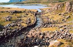 The Viking Canal leaving Loch na h-Airde | |
 | |
| Location | Skye, Scotland |
| OS grid | NG391161 |
| Coordinates | 57.161°N 6.316°W |
The peninsula has a variety of archaeological sites dating from the Neolithic period onwards. The name of the peninsula is Gaelic—the meaning of Rubha an Dùn is evidently "headland of the fort" but the last syllable is less clear. In a different context, Mac an Tàilleir suggests Dùnain may mean either "bird's hill" (Dùn Eòin) or "John's fort" (Dùn Eòin/Dùn Iain).[2]
Prehistoric remains
There is a variety of archaeological sites on the peninsula. To the north are the remains of prehistoric settlements dating from the Neolithic, including a chambered cairn from the 2nd or 3rd millennium BC and a passage grave. A dun to the south of the loch is likely to be of Iron Age provenance.[1][3][4]
Loch na h-Airde
It had been known for some time that an artificial "Viking canal" had been constructed at some point in the past along the length of the stream that runs from the loch to the sea.[3] In 2009 archaeologists discovered boat timbers dated to the 12th century, a stone-built quay in the loch and a system to maintain a constant water level in the loch. The shallow "canal" allowed for boats such as birlinns to exit at high tide. It is now believed that the loch was an important site for maritime activity for many centuries, spanning the Viking and later periods of Scottish clan rule.[5]
In 2011 RCAHMS launched air surveys in the hope of discovering additional artefacts. Marine archaeologist Colin Martin stated: "This site has enormous potential to tell us about how boats were built, serviced and sailed on Scotland's western seaboard in the medieval period – and perhaps during the early historic and prehistoric eras as well... There is no other site quite like this in Scotland."[6]
Later occupation
In the post-Viking era Rubha an Dùnain was the home of the MacAskills, a sect of Clan McLeod, and the peninsula contains the ruins of a small township, including an 18th-century tacksman's house. The area was occupied until the clearances of the 1860s.[4]
Notes
- "Get-a-map". Ordnance Survey. Retrieved 7 May 2011.
- Iain Mac an Tàilleir. "Placenames" (PDF). Pàrlamaid na h-Alba. Archived from the original (PDF) on 17 March 2007. Retrieved 23 July 2010.
- "Skye survey" Archived 2011-09-28 at the Wayback Machine University of Edinburgh. Retrieved 15 March 2008.
- "Skye, Rubh' An Dunain, 'Viking Canal' ". Canmore. Retrieved 7 May 2011.
- Ross, David (7 May 2011) "Now for medieval shipping news". Edinburgh. The Scotsman.
- "Aerial surveys of Viking shipyard on Skye". (5 May 2011) BBC News. Retrieved 6 May 2011.