Roberts, Illinois
Roberts is a village in Ford County, Illinois, United States. The population was 362 at the 2010 census.
Roberts | |
|---|---|
Village | |
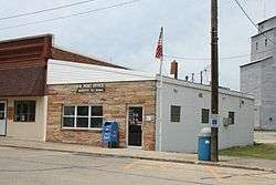 Roberts Illinois Post Office. | |
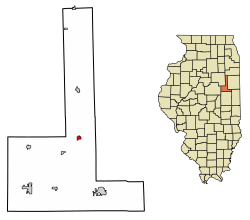 Location of Roberts in Ford County, Illinois. | |
.svg.png) Location of Illinois in the United States | |
| Coordinates: 40°36′48″N 88°10′58″W | |
| Country | United States |
| State | Illinois |
| County | Ford |
| Area | |
| • Total | 0.48 sq mi (1.25 km2) |
| • Land | 0.48 sq mi (1.25 km2) |
| • Water | 0.00 sq mi (0.00 km2) |
| Elevation | 784 ft (239 m) |
| Population (2010) | |
| • Total | 362 |
| • Estimate (2019)[2] | 329 |
| • Density | 683.99/sq mi (263.94/km2) |
| Time zone | UTC-6 (CST) |
| • Summer (DST) | UTC-5 (CDT) |
| ZIP code | 60962 |
| Area code(s) | 217 |
| FIPS code | 17-64655 |
History
Roberts was named for the first permanent settlers in the area, Jesse and Livingston Roberts.[3]
Geography
Roberts is located at 40°36′48″N 88°10′58″W (40.613310, -88.182685).[4]
According to the 2010 census, Roberts has a total area of 0.49 square miles (1.27 km2), all land.[5]
Demographics
| Historical population | |||
|---|---|---|---|
| Census | Pop. | %± | |
| 1880 | 228 | — | |
| 1890 | 325 | 42.5% | |
| 1900 | 446 | 37.2% | |
| 1910 | 466 | 4.5% | |
| 1920 | 444 | −4.7% | |
| 1930 | 410 | −7.7% | |
| 1940 | 379 | −7.6% | |
| 1950 | 416 | 9.8% | |
| 1960 | 504 | 21.2% | |
| 1970 | 506 | 0.4% | |
| 1980 | 422 | −16.6% | |
| 1990 | 397 | −5.9% | |
| 2000 | 387 | −2.5% | |
| 2010 | 362 | −6.5% | |
| Est. 2019 | 329 | [2] | −9.1% |
| U.S. Decennial Census[6] | |||
As of the census[7] of 2000, there were 387 people, 169 households, and 103 families residing in the village. The population density was 746.9 people per square mile (287.3/km2). There were 194 housing units at an average density of 374.4 per square mile (144.0/km2). The racial makeup of the village was 98.97% White and 1.03% Native American. Hispanic or Latino of any race were 1.29% of the population.
There were 169 households out of which 24.9% had children under the age of 18 living with them, 53.3% were married couples living together, 7.7% had a female householder with no husband present, and 38.5% were non-families. 33.7% of all households were made up of individuals and 21.9% had someone living alone who was 65 years of age or older. The average household size was 2.29 and the average family size was 2.99.
In the village, the population was spread out with 23.8% under the age of 18, 5.4% from 18 to 24, 25.8% from 25 to 44, 23.0% from 45 to 64, and 22.0% who were 65 years of age or older. The median age was 42 years. For every 100 females, there were 80.0 males. For every 100 females age 18 and over, there were 82.1 males.
The median income for a household in the village was $32,321, and the median income for a family was $50,000. Males had a median income of $31,250 versus $21,875 for females. The per capita income for the village was $17,926. About 5.0% of families and 7.5% of the population were below the poverty line, including 19.2% of those under age 18 and 2.4% of those age 65 or over.
References
- "2019 U.S. Gazetteer Files". United States Census Bureau. Retrieved July 14, 2020.
- "Population and Housing Unit Estimates". United States Census Bureau. May 24, 2020. Retrieved May 27, 2020.
- Callary, Edward. 2009. Place Names of Illinois. Champaign: University of Illinois Press, p. 298.
- "US Gazetteer files: 2010, 2000, and 1990". United States Census Bureau. 2011-02-12. Retrieved 2011-04-23.
- "G001 - Geographic Identifiers - 2010 Census Summary File 1". United States Census Bureau. Archived from the original on 2020-02-13. Retrieved 2015-12-25.
- "Census of Population and Housing". Census.gov. Retrieved June 4, 2015.
- "U.S. Census website". United States Census Bureau. Retrieved 2008-01-31.
Municipalities and communities of Ford County, Illinois, United States | ||
|---|---|---|
| Cities | Map of Illinois highlighting Ford County | |
| Villages | ||
| Townships | ||
| Unincorporated communities | ||
| Footnotes | ‡This populated place also has portions in an adjacent county or counties | |