Republic, Washington
Republic is a city in Ferry County, Washington, United States. The population was 1,073 at the 2010 census, a 12.5% increase over the 2000 Census.[5] It is the county seat of Ferry County.[6]
Republic, Washington | |
|---|---|
 | |
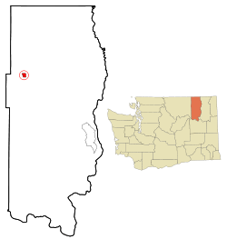 Location of Republic, Washington | |
| Coordinates: 48°38′53″N 118°44′6″W | |
| Country | United States |
| State | Washington |
| County | Ferry |
| Area | |
| • Total | 1.42 sq mi (3.68 km2) |
| • Land | 1.42 sq mi (3.68 km2) |
| • Water | 0.00 sq mi (0.00 km2) |
| Elevation | 2,569 ft (783 m) |
| Population | |
| • Total | 1,073 |
| • Estimate (2019)[3] | 1,066 |
| • Density | 750.70/sq mi (289.87/km2) |
| Time zone | UTC−08:00 (Pacific (PST)) |
| • Summer (DST) | UTC−07:00 (PDT) |
| ZIP Code | 99166 |
| Area code | 509 |
| FIPS code | 53-57850 |
| GNIS feature ID | 1525005[4] |
| Website | City of Republic |
History
Republic was founded by gold prospectors in the late 19th century. Mining claims were first made along Eureka Creek on 21 February 1896, after the northern half of the Colville Indian Reservation was vacated. On 5 March 1896, the Republic claim was staked by Thomas Ryan and Philip Creasor along Granite Creek, another branch of the Sanpoil River. The resulting Republic Mine eventually became the highest producer of gold in the county. On 18 April 1896, the Eureka Mining District was established. In July 1897, Philip Creasor built a two-story hotel at the townsite, originally called Eureka. This town site was platted on 29 April 1898, and the post office name changed to Republic, since there was already a post office named Eureka in the state of Washington. On 8 May 1900, a special election was held which approved incorporation of Republic, and J.J. Sullivan was elected mayor. The town was then officially incorporated on 22 May 1900, and had a population of about 1800.[7][8][9][10][11]
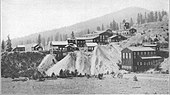
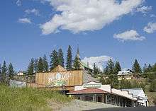
Republic's prominence, initially brought on by the gold rush, started to fade as prospectors and those who supported the mining industry moved away. During the years between 1900 and 1910, the town lost over half its population. Despite this, mining has continued to be an important part of life in Republic, as gold is still mined for in the mountains surrounding the town. Mining is celebrated in the local Prospector's Days, held during the second weekend in June, where locals honor their prospector roots by competing in mining and logging competitions, panning for gold, and watching an old west gun fight. Today, the town of 1,100 is sustained mainly by those people in surrounding farms and ranches, miners who work at the local mine, and tourists looking for a quieter, slower pace of life.
Republic is also the site of the Stonerose Interpretive Center and Fossil Site, famous for the Eocene fossils found in a 49 mya lake bed at the north end of Republic. At the Ferry County Fairgrounds, located three miles (5 km) east of town on State Route 20, is the Ferry County Carousel originally built between 1895 and 1900.
Geography
Republic is located at 48°38′53″N 118°44′6″W (48.648159, −118.734947).[12]
According to the United States Census Bureau, the city has a total area of 1.59 square miles (4.12 km2), all of it land.[13]
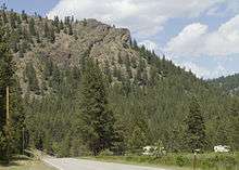
Republic is located near the source of the Sanpoil River in a long valley bordered by the Okanagan Highlands to the west and the Kettle mountain range to the east. Curlew Lake, 7 miles (11 km) long (Elev: 2400 ft), provides fishing and boating to summer visitors northeast of Republic. Swan Lake is small mountain lake 14 miles (23 km) to the south of Republic and also serves to be a popular lake for local residents and tourists to visit. Republic is surrounded by the Colville National Forest and to the south is the Colville Indian Reservation.
Economy
Republic has many businesses that line Clark Ave (the main street through town) including Anderson's Grocery, which was established over a hundred years ago. Ferry County Memorial Hospital is the largest employer in the county.
Climate
Republic experiences a humid continental climate (Köppen Dfb) with cold winters, warm summers and fairly even precipitation year-round, with a drying trend in summer, though there is a secondary uptick in rainfall from April thru June, unlike in much of the rest of the state.
| Climate data for Republic, Washington (1981−2010 normals) | |||||||||||||
|---|---|---|---|---|---|---|---|---|---|---|---|---|---|
| Month | Jan | Feb | Mar | Apr | May | Jun | Jul | Aug | Sep | Oct | Nov | Dec | Year |
| Record high °F (°C) | 53 (12) |
58 (14) |
77 (25) |
89 (32) |
96 (36) |
104 (40) |
108 (42) |
105 (41) |
98 (37) |
87 (31) |
65 (18) |
64 (18) |
108 (42) |
| Average high °F (°C) | 30.5 (−0.8) |
38.0 (3.3) |
48.2 (9.0) |
57.8 (14.3) |
66.2 (19.0) |
72.9 (22.7) |
81.6 (27.6) |
82.0 (27.8) |
72.2 (22.3) |
56.3 (13.5) |
38.4 (3.6) |
28.3 (−2.1) |
56.0 (13.4) |
| Average low °F (°C) | 17.8 (−7.9) |
19.9 (−6.7) |
26.0 (−3.3) |
30.8 (−0.7) |
37.7 (3.2) |
43.8 (6.6) |
47.6 (8.7) |
46.5 (8.1) |
38.8 (3.8) |
30.7 (−0.7) |
24.6 (−4.1) |
16.1 (−8.8) |
31.7 (−0.2) |
| Record low °F (°C) | −33 (−36) |
−34 (−37) |
−19 (−28) |
3 (−16) |
11 (−12) |
25 (−4) |
29 (−2) |
27 (−3) |
14 (−10) |
−5 (−21) |
−20 (−29) |
−38 (−39) |
−38 (−39) |
| Average precipitation inches (mm) | 1.48 (38) |
1.14 (29) |
1.36 (35) |
1.25 (32) |
1.96 (50) |
1.96 (50) |
1.28 (33) |
0.81 (21) |
0.83 (21) |
0.98 (25) |
1.75 (44) |
2.05 (52) |
16.85 (430) |
| Average snowfall inches (cm) | 11.9 (30) |
5.0 (13) |
2.6 (6.6) |
0.5 (1.3) |
0.1 (0.25) |
0 (0) |
0 (0) |
0 (0) |
0 (0) |
0.4 (1.0) |
6.7 (17) |
16.1 (41) |
43.3 (110.15) |
| Average precipitation days (≥ 0.01 in) | 9.2 | 7.0 | 7.9 | 7.6 | 9.5 | 9.2 | 5.3 | 4.3 | 4.9 | 6.2 | 10.4 | 10.8 | 92.4 |
| Average snowy days (≥ 0.1 in) | 7.3 | 3.3 | 2.0 | 0.3 | 0.1 | 0 | 0 | 0 | 0 | 0.2 | 3.7 | 8.4 | 25.3 |
| Source: NOAA (extremes 1899–present)[14] | |||||||||||||
Demographics
| Historical population | |||
|---|---|---|---|
| Census | Pop. | %± | |
| 1900 | 2,050 | — | |
| 1910 | 999 | −51.3% | |
| 1920 | 781 | −21.8% | |
| 1930 | 710 | −9.1% | |
| 1940 | 922 | 29.9% | |
| 1950 | 895 | −2.9% | |
| 1960 | 1,064 | 18.9% | |
| 1970 | 862 | −19.0% | |
| 1980 | 1,018 | 18.1% | |
| 1990 | 940 | −7.7% | |
| 2000 | 954 | 1.5% | |
| 2010 | 1,073 | 12.5% | |
| Est. 2019 | 1,066 | [3] | −0.7% |
| U.S. Decennial Census[15] | |||
2010 census
As of the census[2] of 2010, there were 1,073 people, 493 households, and 263 families living in the city. The population density was 674.8 inhabitants per square mile (260.5/km2). There were 536 housing units at an average density of 337.1 per square mile (130.2/km2). The racial makeup of the city was 89.6% White, 0.1% African American, 2.7% Native American, 1.9% Asian, 0.1% Pacific Islander, 1.4% from other races, and 4.3% from two or more races. Hispanic or Latino of any race were 2.7% of the population.
There were 493 households of which 23.7% had children under the age of 18 living with them, 33.7% were married couples living together, 13.6% had a female householder with no husband present, 6.1% had a male householder with no wife present, and 46.7% were non-families. 37.7% of all households were made up of individuals and 14.6% had someone living alone who was 65 years of age or older. The average household size was 2.05 and the average family size was 2.68.
The median age in the city was 45.3 years. 19.7% of residents were under the age of 18; 7.6% were between the ages of 18 and 24; 22.1% were from 25 to 44; 29.9% were from 45 to 64; and 20.7% were 65 years of age or older. The gender makeup of the city was 46.1% male and 53.9% female.
2000 census
As of the census of 2000, there were 954 people, 411 households, and 244 families living in the city. The population density was 602.9 people per square mile (233.1/km2). There were 500 housing units at an average density of 316.0 per square mile (122.2/km2). The racial makeup of the city was 92.56% White, 0.84% African American, 2.73% Native American, 0.21% Asian, 0.10% Pacific Islander, 0.73% from other races, and 2.83% from two or more races. Hispanic or Latino of any race were 1.99% of the population.
There were 411 households out of which 31.4% had children under the age of 18 living with them, 44.0% were married couples living together, 11.7% had a female householder with no husband present, and 40.4% were non-families. 36.5% of all households were made up of individuals and 15.6% had someone living alone who was 65 years of age or older. The average household size was 2.25 and the average family size was 2.96.
In the city, the population age distribution is spread out with 26.0% under the age of 18, 7.3% from 18 to 24, 24.4% from 25 to 44, 27.9% from 45 to 64, and 14.4% who were 65 years of age or older. The median age was 40 years. For every 100 females, there were 93.9 males. For every 100 females age 18 and over, there were 88.8 males.
The median income for a household in the city was $25,284, and the median income for a family was $30,357. Males had a median income of $28,750 versus $24,286 for females. The per capita income for the city was $14,427. About 20.2% of families and 24.0% of the population were below the poverty line, including 31.5% of those under age 18 and 17.6% of those age 65 or over.
See also
References
- "2019 U.S. Gazetteer Files". United States Census Bureau. Retrieved August 7, 2020.
- "U.S. Census website". United States Census Bureau. Retrieved 2012-12-19.
- "Population and Housing Unit Estimates". United States Census Bureau. May 24, 2020. Retrieved May 27, 2020.
- "US Board on Geographic Names". United States Geological Survey. 2007-10-25. Retrieved 2008-01-31.
- "2010 Census Redistricting Data (Public Law 94-171) Summary File". American FactFinder. United States Census Bureau. Retrieved 17 September 2012.
- "Find a County". National Association of Counties. Retrieved 2011-06-07.
- "Dates of Incorporation, Disincorporation, and Changes of Classification of Washington Cities and Towns". Multiple Research and Service Center of Washington. Archived from the original on 2013-11-26. Retrieved 2013-12-06.
- Steele, Richard (1904). "An Illustrated History of Stevens, Ferry, Okanogan, and Chelan Counties, State of Washington" (PDF). Western Historical Publishing Company. pp. 404–431. Retrieved 2 July 2020.
- Staatz, Mortimer (1960). "THE REPUBLIC GRABEN, A MAJOR STRUCTURE IN NORTHEASTERN WASHINGTON, in Short Papers in the Geological Sciences, USGS Professional Paper 400-B" (PDF). USGS. Retrieved 30 June 2020.
- Full, Roy; Grantham, Robert (1968). Ridge, John (ed.). Ore Deposits of the Republic Mining District, Ferry County, Washington, in Ore deposits of the United States, 1933-1967. New York: The American Institute of Mining, Metallurgical, and Petroleum engineers, Inc. pp. 1481–1494.
- Lindgren, Waldemar; Bancroft, Howland (1914). "REPUBLIC (EUREKA) DISTRICT, in THE ORE DEPOSITS OF ' NORTHEASTERN WASHINGTON, USGS Bulletin 550" (PDF). USGS. Retrieved 30 June 2020.
- "US Gazetteer files: 2010, 2000, and 1990". United States Census Bureau. 2011-02-12. Retrieved 2011-04-23.
- "US Gazetteer files 2010". United States Census Bureau. Archived from the original on 2011-02-20. Retrieved 2012-12-19.
- "NowData - NOAA Online Weather Data". National Oceanic and Atmospheric Administration. Retrieved 2016-07-07.
- United States Census Bureau. "Census of Population and Housing". Retrieved October 4, 2013.
Municipalities and communities of Ferry County, Washington, United States | ||
|---|---|---|
| City |  Map of Washington highlighting Ferry County | |
| CDPs | ||
| Other unincorporated communities | ||
| Indian reservation | ||
| Ghost town | ||
| Footnotes | ‡This populated place also has portions in an adjacent county or counties | |
| Authority control |
|
|---|