Plats
Plats is a commune in the Ardèche department in southern France.
Plats | |
|---|---|
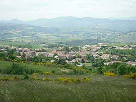 A view of the village of Plats | |
Location of Plats 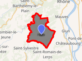
| |
 Plats  Plats | |
| Coordinates: 45°00′39″N 4°46′59″E | |
| Country | France |
| Region | Auvergne-Rhône-Alpes |
| Department | Ardèche |
| Arrondissement | Tournon-sur-Rhône |
| Canton | Tournon-sur-Rhône |
| Intercommunality | Tournon |
| Government | |
| • Mayor (2008–2014) | Laurent Brunel |
| Area 1 | 16.25 km2 (6.27 sq mi) |
| Population (2017-01-01)[1] | 854 |
| • Density | 53/km2 (140/sq mi) |
| Time zone | UTC+01:00 (CET) |
| • Summer (DST) | UTC+02:00 (CEST) |
| INSEE/Postal code | 07177 /07300 |
| Elevation | 178–543 m (584–1,781 ft) (avg. 460 m or 1,510 ft) |
| Website | (in French) www.plats.fr |
| 1 French Land Register data, which excludes lakes, ponds, glaciers > 1 km2 (0.386 sq mi or 247 acres) and river estuaries. | |
Population
| Year | Pop. | ±% |
|---|---|---|
| 1962 | 316 | — |
| 1968 | 350 | +10.8% |
| 1975 | 321 | −8.3% |
| 1982 | 381 | +18.7% |
| 1990 | 443 | +16.3% |
| 1999 | 509 | +14.9% |
| 2008 | 753 | +47.9% |
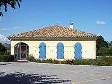
Town hall
Toponymie
Plats was called Planum in 1275, Plana in XIVe, Plais in XVIIIe, then he was called Plas and Plats.[2] The name of the town is written プラ in Japanese, Пла in Russian and 쁠라 in Korean.[3]
Town planning
Housing
| 1968 | 1975 | 1982 | 1990 | 1999 | 2009 |
|---|---|---|---|---|---|
| 134 | 170 | 183 | 198 | 240 | 329 |
Personalities linked to Plats

Commemorative plaque for Marie Banc (Sister Mary of the Angels) at the house of her birth in Plats.
- Marie-France Banc (1876 - 1965), Righteous Among the Nations. She was born in Plats and died in Saint-Félicien.[4] · .[5]
See also
References
Insee
- "INSEE informations for Plats" (PDF) (in French).
- INSEE LOG T1M - Évolution du nombre de logements par catégorie.
Other
- "Populations légales 2017". INSEE. Retrieved 6 January 2020.
- (in French)Website of Plats
- (in French)www.annuaire-mairie.fr
- "Banc Marie-France" (in French).
- "Mère Marie des Anges" (in French).
| Wikimedia Commons has media related to Plats. |
Places adjacent to Plats | |
|---|---|
This article is issued from Wikipedia. The text is licensed under Creative Commons - Attribution - Sharealike. Additional terms may apply for the media files.