Northeast 7th Avenue station
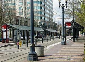
Northeast 7th Avenue is a light rail station on the Blue, Green and Red Lines in Portland, Oregon. It is the 9th stop eastbound on the Eastside MAX.
NE 7th Ave | |||||||||||||||||||||
|---|---|---|---|---|---|---|---|---|---|---|---|---|---|---|---|---|---|---|---|---|---|
| MAX Light Rail station | |||||||||||||||||||||
 | |||||||||||||||||||||
| Location | NE Holladay St & NE 7th Ave Portland, Oregon USA | ||||||||||||||||||||
| Coordinates | 45°31′48″N 122°39′29″W | ||||||||||||||||||||
| Owned by | TriMet | ||||||||||||||||||||
| Platforms | Side platforms | ||||||||||||||||||||
| Tracks | 2 | ||||||||||||||||||||
| Construction | |||||||||||||||||||||
| Parking | none | ||||||||||||||||||||
| Bicycle facilities | bike lockers | ||||||||||||||||||||
| Disabled access | Accessible to people with mobility devices | ||||||||||||||||||||
| History | |||||||||||||||||||||
| Opened | September 5, 1986 | ||||||||||||||||||||
| Services | |||||||||||||||||||||
| |||||||||||||||||||||
The station is located at the area of Northeast 7th Avenue and Holladay Street. The station primarily serves a large complex of Oregon government buildings and office buildings. From 2001 to 2012, this station was located within Fareless Square (renamed the Free Rail Zone in 2010), but the free-ride zone was discontinued in September 2012. Bus line 70-12th/NE 33rd Avenue stops nearby on 9th Avenue.
The station also provides a connection with Portland Streetcar's Loop Service (called the Central Loop until 2015), with southbound streetcars (the A Loop) crossing the MAX tracks just west of the platform and serving a stop one block to the north (stop ID 13611).
Due to major building construction adjacent, the station was temporarily closed[1] for more than one year in 2014–2015. As of mid-March 2014, the closure was scheduled to begin on March 31, 2014, and last about one year.[1] As of April 23, 2015, the station was scheduled to reopen on May 3, 2015.[2]
References
- "NE 7th Ave MAX Station closing for about a year due to adjacent apartment construction project". TriMet. March 17, 2014. Retrieved November 9, 2014.
- "NE 7th Ave MAX Station to reopen May 3" (Press release). TriMet. April 23, 2015. Retrieved 2015-05-03.
External links
- Station information (with westbound ID number) from TriMet
- Station information (with eastbound ID number) from TriMet
- MAX Light Rail Stations – TriMet page
| Buildings and businesses | |
|---|---|
| Public art | |
| Transportation | |
| |