MAX Green Line
The MAX Green Line is a light rail service in Portland, Oregon, United States, operated by TriMet as part of the MAX Light Rail system. It connects Portland State University (PSU), Portland City Center, Northeast Portland, Southeast Portland, and Clackamas Town Center. The line is 15 miles (24.1 km) long and serves 30 stations between the PSU South stations and Clackamas Town Center Transit Center. It is the only service that shares parts of its alignment with the four other MAX services. It shares the Portland Transit Mall with the Orange Line and the Yellow Line, and the Banfield segment of the Eastside MAX with the Blue Line and the Red Line. Southbound from Gateway/Northeast 99th Avenue Transit Center, the Green Line exclusively operates a segment along Interstate 205 (I-205) referred to as the I-205 MAX. Service runs for approximately 211⁄2 hours daily with a headway of 15 minutes during most of the day.
| MAX Green Line | |||||||||||||||||||||||||||||||||||||||||||||||||||||||||||||||||||||||||||||||||||||||||||||||||||||||||||||||||||||||||||||||||||||||||||||||||||||||||||||||||||||||||||||||||||||||||||||||||||||||||||||||||||||||||||||||||||||||||||||||||||||||||||||||||||||||||||||||||||||||||||||||||||||||||||||||||||||||||||||||||||||||||||||||
|---|---|---|---|---|---|---|---|---|---|---|---|---|---|---|---|---|---|---|---|---|---|---|---|---|---|---|---|---|---|---|---|---|---|---|---|---|---|---|---|---|---|---|---|---|---|---|---|---|---|---|---|---|---|---|---|---|---|---|---|---|---|---|---|---|---|---|---|---|---|---|---|---|---|---|---|---|---|---|---|---|---|---|---|---|---|---|---|---|---|---|---|---|---|---|---|---|---|---|---|---|---|---|---|---|---|---|---|---|---|---|---|---|---|---|---|---|---|---|---|---|---|---|---|---|---|---|---|---|---|---|---|---|---|---|---|---|---|---|---|---|---|---|---|---|---|---|---|---|---|---|---|---|---|---|---|---|---|---|---|---|---|---|---|---|---|---|---|---|---|---|---|---|---|---|---|---|---|---|---|---|---|---|---|---|---|---|---|---|---|---|---|---|---|---|---|---|---|---|---|---|---|---|---|---|---|---|---|---|---|---|---|---|---|---|---|---|---|---|---|---|---|---|---|---|---|---|---|---|---|---|---|---|---|---|---|---|---|---|---|---|---|---|---|---|---|---|---|---|---|---|---|---|---|---|---|---|---|---|---|---|---|---|---|---|---|---|---|---|---|---|---|---|---|---|---|---|---|---|---|---|---|---|---|---|---|---|---|---|---|---|---|---|---|---|---|---|---|---|---|---|---|---|---|---|---|---|---|---|---|---|---|---|---|---|---|---|---|---|---|---|---|---|---|---|---|---|---|---|---|---|---|---|---|---|---|
A two-car train on Northwest 5th Avenue of the Portland Transit Mall | |||||||||||||||||||||||||||||||||||||||||||||||||||||||||||||||||||||||||||||||||||||||||||||||||||||||||||||||||||||||||||||||||||||||||||||||||||||||||||||||||||||||||||||||||||||||||||||||||||||||||||||||||||||||||||||||||||||||||||||||||||||||||||||||||||||||||||||||||||||||||||||||||||||||||||||||||||||||||||||||||||||||||||||||
| Overview | |||||||||||||||||||||||||||||||||||||||||||||||||||||||||||||||||||||||||||||||||||||||||||||||||||||||||||||||||||||||||||||||||||||||||||||||||||||||||||||||||||||||||||||||||||||||||||||||||||||||||||||||||||||||||||||||||||||||||||||||||||||||||||||||||||||||||||||||||||||||||||||||||||||||||||||||||||||||||||||||||||||||||||||||
| Type | Light rail | ||||||||||||||||||||||||||||||||||||||||||||||||||||||||||||||||||||||||||||||||||||||||||||||||||||||||||||||||||||||||||||||||||||||||||||||||||||||||||||||||||||||||||||||||||||||||||||||||||||||||||||||||||||||||||||||||||||||||||||||||||||||||||||||||||||||||||||||||||||||||||||||||||||||||||||||||||||||||||||||||||||||||||||||
| System | MAX Light Rail | ||||||||||||||||||||||||||||||||||||||||||||||||||||||||||||||||||||||||||||||||||||||||||||||||||||||||||||||||||||||||||||||||||||||||||||||||||||||||||||||||||||||||||||||||||||||||||||||||||||||||||||||||||||||||||||||||||||||||||||||||||||||||||||||||||||||||||||||||||||||||||||||||||||||||||||||||||||||||||||||||||||||||||||||
| Status | Operational | ||||||||||||||||||||||||||||||||||||||||||||||||||||||||||||||||||||||||||||||||||||||||||||||||||||||||||||||||||||||||||||||||||||||||||||||||||||||||||||||||||||||||||||||||||||||||||||||||||||||||||||||||||||||||||||||||||||||||||||||||||||||||||||||||||||||||||||||||||||||||||||||||||||||||||||||||||||||||||||||||||||||||||||||
| Locale | Portland, Oregon, U.S. | ||||||||||||||||||||||||||||||||||||||||||||||||||||||||||||||||||||||||||||||||||||||||||||||||||||||||||||||||||||||||||||||||||||||||||||||||||||||||||||||||||||||||||||||||||||||||||||||||||||||||||||||||||||||||||||||||||||||||||||||||||||||||||||||||||||||||||||||||||||||||||||||||||||||||||||||||||||||||||||||||||||||||||||||
| Termini | PSU South in downtown Portland (west) Clackamas Town Center Transit Center (east) | ||||||||||||||||||||||||||||||||||||||||||||||||||||||||||||||||||||||||||||||||||||||||||||||||||||||||||||||||||||||||||||||||||||||||||||||||||||||||||||||||||||||||||||||||||||||||||||||||||||||||||||||||||||||||||||||||||||||||||||||||||||||||||||||||||||||||||||||||||||||||||||||||||||||||||||||||||||||||||||||||||||||||||||||
| Stations | 30 | ||||||||||||||||||||||||||||||||||||||||||||||||||||||||||||||||||||||||||||||||||||||||||||||||||||||||||||||||||||||||||||||||||||||||||||||||||||||||||||||||||||||||||||||||||||||||||||||||||||||||||||||||||||||||||||||||||||||||||||||||||||||||||||||||||||||||||||||||||||||||||||||||||||||||||||||||||||||||||||||||||||||||||||||
| Daily ridership | 20,640 (as of September 2018)[1] | ||||||||||||||||||||||||||||||||||||||||||||||||||||||||||||||||||||||||||||||||||||||||||||||||||||||||||||||||||||||||||||||||||||||||||||||||||||||||||||||||||||||||||||||||||||||||||||||||||||||||||||||||||||||||||||||||||||||||||||||||||||||||||||||||||||||||||||||||||||||||||||||||||||||||||||||||||||||||||||||||||||||||||||||
| Website | MAX Green Line | ||||||||||||||||||||||||||||||||||||||||||||||||||||||||||||||||||||||||||||||||||||||||||||||||||||||||||||||||||||||||||||||||||||||||||||||||||||||||||||||||||||||||||||||||||||||||||||||||||||||||||||||||||||||||||||||||||||||||||||||||||||||||||||||||||||||||||||||||||||||||||||||||||||||||||||||||||||||||||||||||||||||||||||||
| Operation | |||||||||||||||||||||||||||||||||||||||||||||||||||||||||||||||||||||||||||||||||||||||||||||||||||||||||||||||||||||||||||||||||||||||||||||||||||||||||||||||||||||||||||||||||||||||||||||||||||||||||||||||||||||||||||||||||||||||||||||||||||||||||||||||||||||||||||||||||||||||||||||||||||||||||||||||||||||||||||||||||||||||||||||||
| Opened | September 12, 2009 | ||||||||||||||||||||||||||||||||||||||||||||||||||||||||||||||||||||||||||||||||||||||||||||||||||||||||||||||||||||||||||||||||||||||||||||||||||||||||||||||||||||||||||||||||||||||||||||||||||||||||||||||||||||||||||||||||||||||||||||||||||||||||||||||||||||||||||||||||||||||||||||||||||||||||||||||||||||||||||||||||||||||||||||||
| Owner | TriMet | ||||||||||||||||||||||||||||||||||||||||||||||||||||||||||||||||||||||||||||||||||||||||||||||||||||||||||||||||||||||||||||||||||||||||||||||||||||||||||||||||||||||||||||||||||||||||||||||||||||||||||||||||||||||||||||||||||||||||||||||||||||||||||||||||||||||||||||||||||||||||||||||||||||||||||||||||||||||||||||||||||||||||||||||
| Operator(s) | TriMet | ||||||||||||||||||||||||||||||||||||||||||||||||||||||||||||||||||||||||||||||||||||||||||||||||||||||||||||||||||||||||||||||||||||||||||||||||||||||||||||||||||||||||||||||||||||||||||||||||||||||||||||||||||||||||||||||||||||||||||||||||||||||||||||||||||||||||||||||||||||||||||||||||||||||||||||||||||||||||||||||||||||||||||||||
| Character | At-grade, elevated, and underground | ||||||||||||||||||||||||||||||||||||||||||||||||||||||||||||||||||||||||||||||||||||||||||||||||||||||||||||||||||||||||||||||||||||||||||||||||||||||||||||||||||||||||||||||||||||||||||||||||||||||||||||||||||||||||||||||||||||||||||||||||||||||||||||||||||||||||||||||||||||||||||||||||||||||||||||||||||||||||||||||||||||||||||||||
| Rolling stock |
| ||||||||||||||||||||||||||||||||||||||||||||||||||||||||||||||||||||||||||||||||||||||||||||||||||||||||||||||||||||||||||||||||||||||||||||||||||||||||||||||||||||||||||||||||||||||||||||||||||||||||||||||||||||||||||||||||||||||||||||||||||||||||||||||||||||||||||||||||||||||||||||||||||||||||||||||||||||||||||||||||||||||||||||||
| Technical | |||||||||||||||||||||||||||||||||||||||||||||||||||||||||||||||||||||||||||||||||||||||||||||||||||||||||||||||||||||||||||||||||||||||||||||||||||||||||||||||||||||||||||||||||||||||||||||||||||||||||||||||||||||||||||||||||||||||||||||||||||||||||||||||||||||||||||||||||||||||||||||||||||||||||||||||||||||||||||||||||||||||||||||||
| Line length | 15 mi (24.1 km)[2] | ||||||||||||||||||||||||||||||||||||||||||||||||||||||||||||||||||||||||||||||||||||||||||||||||||||||||||||||||||||||||||||||||||||||||||||||||||||||||||||||||||||||||||||||||||||||||||||||||||||||||||||||||||||||||||||||||||||||||||||||||||||||||||||||||||||||||||||||||||||||||||||||||||||||||||||||||||||||||||||||||||||||||||||||
| Number of tracks | 2 | ||||||||||||||||||||||||||||||||||||||||||||||||||||||||||||||||||||||||||||||||||||||||||||||||||||||||||||||||||||||||||||||||||||||||||||||||||||||||||||||||||||||||||||||||||||||||||||||||||||||||||||||||||||||||||||||||||||||||||||||||||||||||||||||||||||||||||||||||||||||||||||||||||||||||||||||||||||||||||||||||||||||||||||||
| Track gauge | 4 ft 8 1⁄2 in (1,435 mm) standard gauge | ||||||||||||||||||||||||||||||||||||||||||||||||||||||||||||||||||||||||||||||||||||||||||||||||||||||||||||||||||||||||||||||||||||||||||||||||||||||||||||||||||||||||||||||||||||||||||||||||||||||||||||||||||||||||||||||||||||||||||||||||||||||||||||||||||||||||||||||||||||||||||||||||||||||||||||||||||||||||||||||||||||||||||||||
| Electrification | 750 V DC, overhead catenary | ||||||||||||||||||||||||||||||||||||||||||||||||||||||||||||||||||||||||||||||||||||||||||||||||||||||||||||||||||||||||||||||||||||||||||||||||||||||||||||||||||||||||||||||||||||||||||||||||||||||||||||||||||||||||||||||||||||||||||||||||||||||||||||||||||||||||||||||||||||||||||||||||||||||||||||||||||||||||||||||||||||||||||||||
| |||||||||||||||||||||||||||||||||||||||||||||||||||||||||||||||||||||||||||||||||||||||||||||||||||||||||||||||||||||||||||||||||||||||||||||||||||||||||||||||||||||||||||||||||||||||||||||||||||||||||||||||||||||||||||||||||||||||||||||||||||||||||||||||||||||||||||||||||||||||||||||||||||||||||||||||||||||||||||||||||||||||||||||||
Planning for the first light rail services to Clackamas County began in the mid-1980s with the announcement of two separate lines, of which one was envisioned between Portland International Airport and Clackamas Town Center via I-205. Feasibility studies conducted in the early 1990s eventually shifted plans away from I-205 and culminated in the South/North Line proposal. This plan failed to secure voter-backed funding over several ballot measures, resulting in its cancellation in 1998. In 2001, regional planners developed the South Corridor transportation project, a two-phased revision of the initial proposal that sought the addition of light rail to I-205 and the Portland Transit Mall in its first phase. With the support of local governments and residents, the project was approved in 2003. Light rail construction began in early 2007 and Green Line service commenced on September 12, 2009. The line is the third busiest in the system, carrying an average of 20,640 riders per day on weekdays in September 2018.
In the future, TriMet plans to extend MAX to Southwest Portland, Tigard, and Tualatin with the Southwest Corridor light rail project. If local funding is approved by voters in November 2020, the 11-mile (18 km) extension would begin construction in 2022 and open in 2027 with service from the Green Line.
I-205 history
Early proposals
In the mid-1980s, Metro regional government announced plans to introduce light rail to Clackamas County with the proposal of two lines: one between Portland International Airport and Clackamas Town Center via I-205,[3] and the other between downtown Portland, Milwaukie, and Oregon City via McLoughlin Boulevard.[4] A panel of local and state officials, known as the Joint Policy Advisory Committee on Transportation (JPACT), affirmed their endorsement of an I-205 line in 1987 with a request to start preliminary engineering for light rail in lieu of an originally planned busway.[5][6] Their preferred alignment had been the I-205 Transitway, an unfinished, grade-separated transit right-of-way built during I-205's construction in the late 1970s and early 1980s.[7] As plans to extend MAX (for Metropolitan Area Express), the region's existing light rail system, westward to Hillsboro in Washington County took priority for federal funding, TriMet called on local businesses and governments in Clackamas County to subsidize the proposed $88 million I-205 route.[8]
A dispute between Washington and Clackamas county officials followed, with Clackamas County vying for additional federal assistance, including $17 million in excess funds sourced from the partially realized I-205 Transitway.[9][10] In January 1989, in an effort to settle the dispute, Metro approved a 10-year regional transportation plan in which it reasserted the westside line's priority and commissioned preliminary work on the I-205 line, as well as a study for a line to Milwaukie.[11] The U.S. Senate Committee on Appropriations approved a financing package in September, which provided $2 million to assess both segments. At the behest of Oregon Senator Mark Hatfield and Washington Senator Brock Adams, who were members of the committee, a segment further north to Clark County, Washington became part of the proposals.[12][13]
Initial studies examined extending the proposed I-205 line further north across the Columbia River to Vancouver Mall or the Clark County Fairgrounds.[14][13] As the studies analyzed various alternative routes, however, support eventually shifted to an alignment along the busier I-5 and Willamette River corridors.[15] A 25-mile (40 km) route from Hazel Dell, Washington through downtown Portland to Clackamas Town Center called the South/North Line was finalized in 1994.[16] Estimated to cost around $2.8 billion, Portland area voters approved a $475 million bond measure on November 8, 1994, to cover Oregon's share.[17] A Clark County vote to fund Washington's portion, which would have been sourced through sales and vehicle excise tax increases, was subsequently defeated on February 7, 1995.[18] TriMet later sought funding for various scaled-back revisions of the South/North Line that generally followed a route between North Portland and Clackamas Town Center, which voters rejected in 1996 and 1998.[19][20] In 1997, an unsolicited proposal from engineering company Bechtel led to a public–private partnership that built an extension of MAX to Portland International Airport using much of the northern half of the I-205 Transitway; this extension opened in 2001 with service from the Red Line.[21]
Revival and funding
.jpg)
In May 2001, a Metro planning committee convened to discuss renewed light rail plans to downtown Milwaukie, as well as to revisit the idea of running MAX on I-205 from Gateway/Northeast 99th Avenue Transit Center to Clackamas Town Center.[22] The following month, the committee announced the $8.8 million South Corridor transportation study, which evaluated both options.[23] In 2002, a supplemental draft environmental impact statement (EIS) based on the original South/North Line EIS was published.[24]:P-1 Metro narrowed down five alternatives in January 2003; these included building both light rail lines, a combination of one light rail service and one improved bus service, bus rapid transit, and dedicated bus lanes.[25] The study's task force recommended both light rail options; they proposed a two-phased development plan, starting with the addition of light rail to I-205 by 2009,[26] followed by the completion of a Portland to Milwaukie line five years later.[27] The existing I-205 Transitway right-of-way and the potential for no new taxes were two factors that led to the selection of the I-205 corridor for the first phase.[28] With the approval of local residents,[29][30] affected jurisdictions each endorsed this proposal by April 2003.[26][31] An amendment to include adding tracks on the Portland Transit Mall as part of the first phase was prepared the following October.[24]:P-2 TriMet published the final EIS in December 2004 and began land acquisition for park and ride facilities in November 2005.[2][32]
The combined I-205 MAX and transit mall revitalization project was approved by the federal government on February 7, 2006.[33] The project was budgeted at $575.7 million (equivalent to $669 million in 2018 dollars),[34] of which approximately $355.7 million went to I-205.[35] TriMet negotiated a local match of 40 percent, or $197.4 million (unadjusted) of total funding in July 2004.[36] Federal funding, which covered the remaining 60 percent, or about $345 million, was approved in February 2006 under the New Starts program.[33][37] The head of the Federal Transit Administration (FTA) signed the full-funding agreement in Portland on July 3, 2007.[38] In May 2009, the project received $32 million in federal stimulus funding from the American Recovery and Reinvestment Act of 2009, an amount already committed to the project by the federal government but made available so that TriMet could retire debt earlier.[39] The City of Portland provided $15 million in bonds paid off by raising parking meter fees, $17 million from a local improvement district, and $6.3 million from systems and utilities charges.[36] Around $36 million came from Clackamas County urban renewal funds, collected from property taxes within the Clackamas Town Center urban renewal district.[40][41] TriMet contributed $20.5 million,[42] and the Portland Development Commission provided $20 million.[36] An additional $15.3 million was spent by downtown businesses to improve retail spaces along the transit mall.[43]
Construction and opening

TriMet awarded the construction of the I-205 MAX to South Corridor Constructors, a joint venture composed of Stacy and Witbeck, F.E. Ward Constructors—both of which had worked on the preceding Interstate MAX project—and Granite Construction Company; it was granted through a design–build contract in February 2004.[44] Construction commenced in February 2007.[37][45] This marked the start of a 21⁄2-year closure of sections of the I-205 Bike Path.[46] A new mixed-use path linking Clackamas County to the South Park Blocks in downtown Portland was paved as a permanent alternative.[47][48] Preliminary work involved erecting light rail bridges over Southeast Johnson Creek Boulevard and Southeast Harold Street, and excavating light rail underpasses below Southeast Stark and Washington streets.[47] Crews were at work along the 3-mile (4.8 km), two-station segment within Clackamas County by November 2007.[49] The line was over 70 percent complete by November 2008, with tracks laid from Gateway Transit Center to Southeast Flavel Street.[50] TriMet ordered 22 Siemens S70 cars to serve the expansion. Referred to as Type 4, the first car was delivered in 2009;[51] it made its first test run in March and entered service on August 6, 2009.[52][53] The line's first end-to-end test run, attended by local and state dignitaries, occurred in July 2009.[54]
Green Line service commenced on September 12, 2009.[55][56] The two extensions added a total of 8.3 miles (13.4 km) of newly constructed light rail tracks. The I-205 section accounted for 6.5 miles (10.5 km)—the Portland Transit Mall section, 1.8 miles (2.9 km).[57][58] Opening day festivities, paid for by sponsors and donations, were held at Clackamas Town Center and PSU. As many as 40,000 people showed up to ride the trains, which were free that day.[55] To address its $31 million budget deficit, TriMet simultaneously eliminated four bus routes and implemented service cuts to 49 other lines.[59]
Transit mall revitalization

A north–south light rail alignment through downtown Portland had been considered as early as the 1980s. In 1991, following recommendations made by a citizen advisory committee, the Portland City Council commissioned a feasibility study for a potential subway line beneath the 1977-built Portland Transit Mall on 5th and 6th avenues, then served only by buses.[60] During the planning stages of the South/North Line in 1994, government planners introduced a surface light rail alternative,[61] which was later favored by the project's steering committee when it concluded a $250 million tunnel would be too costly.[62][63] Following the cancellation of the South/North Line, the city reserved revitalization efforts for the transit mall amid proposals to rebuild it to allow curbside parking in 2002.[64]
In 2003, TriMet planners began to reconsider the addition of light rail to the Portland Transit Mall. Planning for the second phase of the South Corridor transportation study, which aimed to extend MAX south to Milwaukie, revealed that a fourth service on the existing tracks along Southwest Morrison and Yamhill streets, served already by the Blue, Red, and Yellow lines, would push the downtown alignment to maximum capacity.[65] Additionally, Portland business leaders pushed for the construction of a new bridge that would lead to the southern end of the transit mall instead of using the Hawthorne Bridge,[66] fearing the latter would form a traffic bottleneck.[25][27] A study conducted subsequently by TriMet proposed stations on either the left, right, or middle lanes of the transit mall,[67] and planners selected a hybrid center-lane travel with right-side boarding option in April 2004.[68] Local governments approved the revitalization plan by the following month,[69] combining it with the first-phase construction of the I-205 MAX.[24]:P-2 Consisting of seven stations per split on 5th and 6th Avenues,[2] the project extended the existing transit mall from 44 to 117 block faces between Portland Union Station and PSU.[70] It also added a continuous travel lane for private vehicles, which had not been present in the corridor's original bus-only design.[71]

The contract was awarded to a joint venture of Stacy and Witbeck and Kiewit Pacific.[71] Preparation work began with the rerouting of 17 bus lines to 3rd and 4th avenues, six lines to Southwest Columbia and Jefferson streets, and one line, the 14–Hawthorne, to Southwest 2nd Avenue.[72][73] Construction commenced on January 14, 2007, with the corridor's temporary closure.[74][75] Owing to techniques learned from the Interstate MAX project, businesses were kept open while blocks were closed off in three- to four-block sections from north to south,[76][77] minimizing disruptions.[78] The original transit mall had been built with mortar-set bricks, which proved difficult to maintain. In the reconstruction, TriMet experimented with sand-set brick paving as recommended by British civil engineer John Knapton, who studied road building methods used by the Romans.[79] Tracks were laid 25 inches (64 cm) into the surface street, while water pipes and sewers were buried 6 feet (1.8 m) to 25 feet (7.6 m) underground.[71] The last section of rail on the transit mall was installed in May 2008.[80] From June to August 2008, the upper deck of the Steel Bridge was closed to connect the existing MAX tracks with the new tracks.[81]
5th and 6th avenues reopened to vehicular traffic in July 2008, two months ahead of schedule.[82] TriMet began line testing in January 2009, initially with light rail cars hauled by a truck,[83] then with the system's new Type 4 trains.[52] Bus service returned to the transit mall on May 24, 2009.[84] Three months later, on August 30, 2009, the light rail portion opened with inaugural service from the Yellow Line, which was rerouted from its original downtown alignment with the Blue and Red lines on First Avenue and Southwest Morrison and Yamhill streets.[85] Green Line trains began serving the Portland Transit Mall during the opening of the I-205 MAX on September 12, 2009.[55]
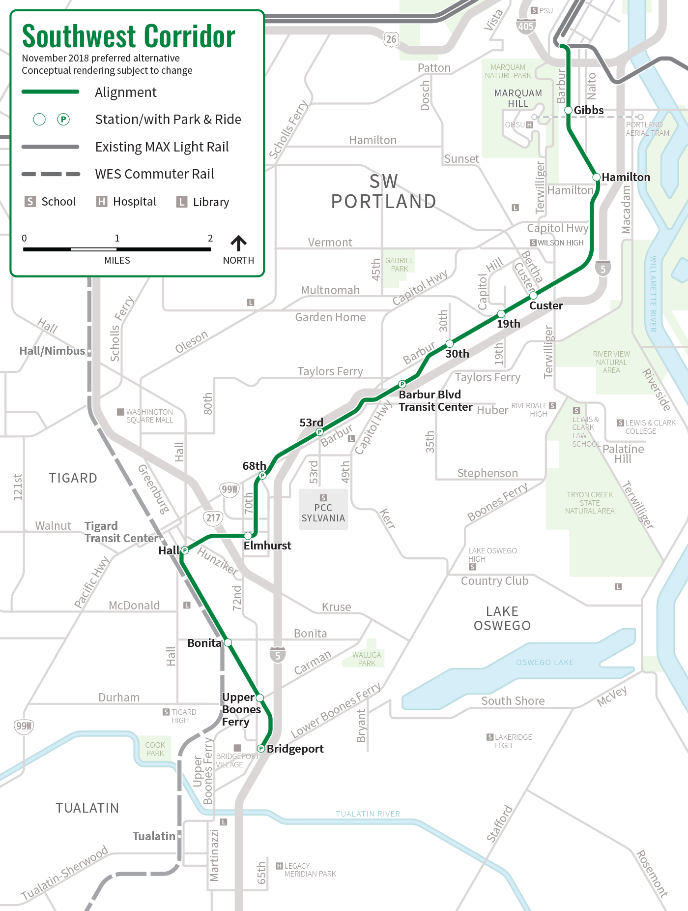
Planned Southwest Corridor extension
Southwest Corridor planned route | ||||||||||||||||||||||||||||||||||||||||||||||||||||||||||||||||||||||||||||||||||||||||||||||||||||||||||||||||||||||||||||||||||||||||||||||||||||||||||||||||||||||||
|---|---|---|---|---|---|---|---|---|---|---|---|---|---|---|---|---|---|---|---|---|---|---|---|---|---|---|---|---|---|---|---|---|---|---|---|---|---|---|---|---|---|---|---|---|---|---|---|---|---|---|---|---|---|---|---|---|---|---|---|---|---|---|---|---|---|---|---|---|---|---|---|---|---|---|---|---|---|---|---|---|---|---|---|---|---|---|---|---|---|---|---|---|---|---|---|---|---|---|---|---|---|---|---|---|---|---|---|---|---|---|---|---|---|---|---|---|---|---|---|---|---|---|---|---|---|---|---|---|---|---|---|---|---|---|---|---|---|---|---|---|---|---|---|---|---|---|---|---|---|---|---|---|---|---|---|---|---|---|---|---|---|---|---|---|---|---|---|---|
| ||||||||||||||||||||||||||||||||||||||||||||||||||||||||||||||||||||||||||||||||||||||||||||||||||||||||||||||||||||||||||||||||||||||||||||||||||||||||||||||||||||||||
A planned expansion of MAX, referred to as the Southwest Corridor light rail project, would add 13 stations over a new 11-mile (18 km) track extension. It would connect downtown Portland to Southwest Portland and the cities of Tigard and Tualatin. The line would start at the PSU South stations on the southern end of the Portland Transit Mall in downtown Portland.[86]:19, 39, 191 It would head south over I-405, run between Marquam Hill and I-5, and proceed southwest beyond Capitol Highway to connect with Barbur Transit Center. Two bridges would take the line over I-5 into the Tigard Triangle. It would traverse a fourth bridge over Oregon Route 217 (OR 217) and proceed towards Tigard Transit Center, which would connect it with WES Commuter Rail. Adjacent to the SW Hall Blvd station would be a newly constructed rail yard built to house rolling stock and maintenance operations. The line would continue down beside the old Oregon Electric Railway right-of-way (currently owned by Portland & Western Railroad) before terminating at Bridgeport Village.[87]:4[88]
Much of the extension would run along the center of Southwest Barbur Boulevard, a part of OR 99W. It is being designed to connect riders to the upper campus of OHSU via pedestrian link and PCC Sylvania via shuttle bus. End-to-end travel time would take approximately 30 minutes.[89] At an estimated cost of $2.6 billion to $2.9 billion,[90] the project will be included in a regional transportation funding measure that will be voted on in 2020.[91] If approved, the extension is expected to open in 2027 and serve approximately 43,000 riders by 2035.[89]
Project history
A segment of OR 99W, between Portland and Sherwood, was identified as one of the region's next high capacity transit corridors in Metro's 2035 Regional Transportation Plan adopted on June 10, 2010.[92]:11–14 The FTA granted Metro $2 million in January 2011 to begin studies for this area, which was formally called the Southwest Corridor. The funds focused on the assessment of various alternatives, including light rail, commuter rail, streetcar, and bus rapid transit.[93] The Southwest Corridor Plan officially launched on September 28, 2011, integrating the individual land use plans begun by each of the involved communities and initiating the development of a unified transportation network.[94]:1
In June 2013, Metro released the corridor's high-capacity transit analysis, in which it selected light rail and bus rapid transit as the main alternatives.[95]:1 Citing a lack of present and future demand, the analysis eliminated further planning using the alternatives to Sherwood. A streetcar line and a high-occupancy vehicle lane on I-5, among other previously considered options, were also abandoned. In response to local opposition to the removal of automobile lanes from OR 99W in Tigard, the steering committee recommended rerouting the proposed alignment through the Tigard Triangle.[96]:3 A refinement recommendation was announced in June 2014 selecting a preliminary route from the southern end of the Portland Transit Mall in downtown Portland to just east of Tualatin station in downtown Tualatin;[97]:6–7 this was later shortened to terminate at Bridgeport Village.[88] Proposals to serve OHSU on Marquam Hill, Hillsdale, and PCC Sylvania with tunnels were dropped from the plan because they would be costly, have severe construction impacts, and attract few new transit riders.[98][99] Connecting OHSU to a surface transit line through elevators or escalators is being studied.[100]
In May 2016, light rail was chosen as the preferred mode alternative over bus rapid transit.[101] Tigard voters, after passing a measure requiring voters to approve the construction of any high-capacity transit built within city limits,[102] approved the light rail extension the following September.[103]
In light of a budget gap of $462 million, planners proposed reducing lanes on Barbur Boulevard and shortening the line's route to terminate in downtown Tigard. Both proposals were rejected in November 2019. Private negotiations, as well as Metro's approval to increase the project's requested budget by $125 million in the 2020 ballot measure, has reduced the budget gap to around $100 million.[104]
Route

The Green Line is 15 miles (24.1 km) long; it serves three distinct segments of the MAX system: the Portland Transit Mall, Eastside MAX, and I-205 MAX.[2] The line's western termini are the PSU South stations at the southern end of the Portland Transit Mall within the PSU campus.[105] Tracks along the transit mall are split between 5th and 6th Avenues; trains travel northbound on 6th Avenue and southbound on 5th Avenue.[106] From the PSU South stations, the line traverses the length of the transit mall, which ends near Union Station.[107] Along the way, it crosses with the Portland Streetcar near the PSU Urban Center stations and with the east–west MAX lines on Yamhill and Morrison streets near the Pioneer Courthouse and Pioneer Courthouse Square.[108][109] A wye connects the tracks near the intersection of Northwest 5th Avenue and Hoyt Street.[107] The line continues southeast onto the Northwest Glisan Street Ramp and across the Willamette River via the Steel Bridge.[110]
On the east end of the Steel Bridge, the Green Line joins the Eastside MAX alignment, serving the stations between the Rose Quarter Transit Center and Gateway/Northeast 99th Avenue Transit Center.[111] On this segment, it runs at-grade along Holladay Street at the Rose Quarter and Lloyd District, and then along the northern edge of the Banfield Freeway.
Beyond Gateway Transit Center, the Green Line proceeds south, entering the I-205 MAX segment to the east of I-205. Throughout most of this stretch, the line is grade-separated as part of the I-205 Transitway, running either above or below roadway intersections. The exception is an at-grade crossing at Southeast Flavel Street.[112] Much of this segment also parallels the I-205 Bike Path. Between Southeast Lincoln and Grant streets, the tracks enter a tunnel beneath the freeway, exiting on the opposite side just north of Southeast Division Street.[7] Above Johnson Creek Boulevard, it travels on a 1,400-foot (430 m)-long overpass, the longest new structure on the alignment. South of Southeast Fuller Road station, the line dips under the Otty Road and Monterey Avenue overpasses before terminating at the Clackamas Town Center Transit Center, near Southeast Sunnyside Road.[110]
The Green Line shares its northbound alignment on the Portland Transit Mall with Yellow Line trains, which diverge towards the Expo Center in North Portland after crossing the Steel Bridge, and southbound with Orange Line trains, which continue beyond PSU South/Southwest 5th and Jackson station for Southeast Park Avenue station in Milwaukie. The Green Line also shares a portion of the Eastside MAX with Blue Line and Red Line services between Rose Quarter Transit Center and Gateway Transit Center, being the newest to serve the alignment in 2009.[110]
Stations


The I-205 MAX, which the Green Line serves exclusively, consists of eight stations between Southeast Main Street and Clackamas Town Center Transit Center, occupying a segment of the I-205 Transitway south of the I-5 and I-205 interchange. The Portland Transit Mall, which the Green Line serves along with the Orange Line and the Yellow Line, consists of seven stations per direction. Green Line trains serve 30 stations total, of which the remaining eight are between Rose Quarter Transit Center and Gateway Transit Center, shared with the Blue Line and the Red Line.[113]
The Green Line provides connections to local and intercity bus services at various stops across the line, the Portland Streetcar at four stops in and near downtown Portland,[114] and Amtrak via Union Station.[106]
| Key | |
|---|---|
| † | Terminus |
| → | Eastbound travel only |
| ← | Westbound travel only |
Service
On weekdays, the Green Line operates for approximately 211⁄2 hours per day. The first train starts westbound at 3:40 am from Gateway Transit Center. From 4:19 am, the first five eastbound trains originate at the Ruby Junction/East 197th Avenue station as the Blue Line and change to the Green Line at Gateway Transit Center. The first trains from PSU South/Southwest 6th & College station and Clackamas Town Center Transit Center to run the full length of the line depart at 5:27 am and 4:55 am, respectively. End-to-end travel takes around 50 minutes. In the evenings, certain eastbound trains turn into the Blue Line at Rose Quarter Transit Center and terminate at Ruby Junction. The last eastbound train departs PSU South station at 12:28 am and the last westbound train departs Clackamas Town Center Transit Center at 12:41 am. On weekends, the Green Line runs on a slightly reduced schedule, beginning service approximately 40 minutes later.[116] TriMet designates the line as a "Frequent Service" route, with service running on a headway of 15 minutes during most of the day, which extends up to 30 minutes in the early morning and late evening hours.[117]
Ridership
Prior to the start of construction, a PSU study estimated 46,500 new boardings along the Green Line by 2025.[47] During its first year in operation, TriMet planners projected 25,250 average weekday riders; fewer people than expected actually utilized the line on its first day of weekday service.[118] By the following month, however, TriMet recorded approximately 17,000 trips per day.[119] The average daily ridership in June 2010 was 19,500,[120] increasing to 24,300 by April 2012.[121] As of September 2018, the Green Line records an average weekday ridership of 20,640, making it the third-busiest MAX service.[1] The drop in ridership, experienced systemwide, is attributed to crime and lower-income riders being forced out of the inner city by rising housing prices.[122][123]
Note
- This list of service connections excludes TriMet bus connections. For a complete list that includes all transfers, see: List of MAX Light Rail stations.
References
- "September 2018 Monthly Performance Report" (PDF). TriMet. Archived from the original (PDF) on February 22, 2019. Retrieved February 21, 2019.
- Pantell, Susan (December 2009). "Portland: New Green Line Light Rail Extension Opens". Light Rail Now. Archived from the original on May 12, 2016. Retrieved September 1, 2018.
- Kohler, Vince (July 11, 1985). "Light-rail line study under way". The Oregonian. p. D4.
- "Where's east side light rail going next?". The Oregonian. April 3, 1986. p. 2.
- Bodine, Harry (September 30, 1987). "Light-rail expansion backed by officials". The Oregonian. p. B12.
- Bodine, Harry (October 27, 1987). "Panel puts top priority on mass transit, major highway projects". The Oregonian. p. B4.
- Redden, Jim (September 10, 2009). "After 35 years of waiting, TriMet's Green Line hits all the parties: Thousands ride new I-205 line that was born of a '70s freeway rebellion". Portland Tribune. Archived from the original on June 8, 2011. Retrieved May 13, 2014.
- Kohler, Vince (May 23, 1988). "Joint efforts of business, government could spur rail line; both groups need to finance, back line along I-205, panel says". The Oregonian. p. B5.
- Green, Ashbel (October 6, 1988). "County officials debate light-rail routes". The Oregonian. p. W1.
- Kohler, Vince (January 17, 1991). "Clackamas County seeks federal money for rail line". The Oregonian. p. C2.
- Bodine, Harry (January 14, 1989). "Metro OKs $1.5 billion transit plan". The Oregonian. p. D1.
- Kohler, Vince; Stewart, Bill (September 10, 1989). "Light-rail proposals gain ground in Congress; senate panel approves transportation funding bill, aiding plans for new Oregon City, Vancouver lines". The Oregonian. p. C2.
- Stewart, Bill (January 12, 1993). "County light-rail project gains momentum". The Oregonian. p. B2.
- Stewart, Bill (September 24, 1989). "Clark County light-rail plans chugging along; more than $1 million will be spent on studies on both sides of the river". The Oregonian. p. C2.
- Oliver, Gordon (March 11, 1993). "Citizens advisory committee endorses pair of light-rail routes". The Oregonian. p. B3.
- Maves, Norm Jr. (October 27, 1994). "25-mile route encompasses hundreds of steps". The Oregonian. p. 1.
- Oliver, Gordon (November 10, 1994). "One down, more to go for reality of north–south rail line". The Oregonian. p. C10.
- Oliver, Gordon (February 8, 1995). "Clark County turns down north–south light rail". The Oregonian. p. 1.
- Oliver, Gordon; Hunsenberger, Brent (November 7, 1996). "Tri-Met still wants that rail line to Clackamas County". The Oregonian. p. D1.
- Oliver, Gordon (November 7, 1998). "South/North Line backers find themselves at a loss after election day defeat". The Oregonian. p. B1.
- Stewart, Bill (September 7, 2001). "Airport MAX rolls out Monday". The Oregonian. p. B1.
- Rose, Joseph (May 8, 2001). "New MAX plan tries to the double-team approach". The Oregonian. p. D1.
- Rose, Joseph (June 6, 2001). "Metro planners will study two south light-rail lines". The Oregonian. p. E3.
- United States Department of Transportation (October 2003). Downtown Amendment to the South Corridor Project Supplemental Environmental Impact Statement (Report). Retrieved June 25, 2019.
- Oppenheimer, Laura (January 27, 2003). "New MAX plans arrive for input; a revived bid to expand light rail to Milwaukie, one of five transit proposals, may fare better now that former critics are on board". The Oregonian. p. E1.
- Leeson, Fred (March 27, 2003). "TriMet board agrees to plan for southeast light-rail lines". The Oregonian. p. C2.
- Oppenheimer, Laura (February 17, 2003). "South Corridor MAX plan unveiled". The Oregonian. p. E1.
- Briggs, Kara (July 24, 2002). "Metro considers transit options along I-205". The Oregonian. p. D2.
- McCarthy, Dennis (February 25, 2002). "Happy Valley-area leaders mostly argue for light rail". The Oregonian. p. B2.
- Parker, Andy (March 22, 2004). "Polls say you like light rail: What say you?". The Oregonian. p. B1.
- Oppenheimer, Laura (April 18, 2003). "Metro gives final OK to MAX lines". The Oregonian. p. D6.
- Mayes, Steve (November 14, 2005). "I-205 light rail heads to next stop: Buying land". The Oregonian. p. B1.
- Mayer, James (February 8, 2006). "Metro rail projects hit funding fast track". The Oregonian. p. A1.
- Rivera, Dylan (July 1, 2009). "Green light for the Green Line". The Oregonian. Archived from the original on August 22, 2019. Retrieved August 22, 2019.
- Redden, Jim (May 20, 2009). "TriMet: Mall can be safe, orderly". Portland Tribune. Retrieved July 2, 2019.
- Leeson, Fred (July 29, 2004). "Plan would raise parking fees". The Oregonian. p. B1.
- Mayer, James (February 8, 2007). "Light rail in Bush's 2008 budget". The Oregonian. p. C5.
- Mayer, James (July 3, 2007). "Money lines up for light-rail expansions". The Oregonian. p. C2.
- Carinci, Justin (May 8, 2009). "MAX green line gets $32 million". Daily Journal of Commerce. Archived from the original on July 23, 2012. Retrieved August 21, 2012.
- Hunsberger, Sarah (July 14, 2004). "$36.3 million added to light-rail". The Oregonian. p. C1.
- Hunsberger, Sarah (June 1, 2006). "Clackamas County unfurls lengthy to-do list for next fiscal year". The Oregonian. p. 10.
- Mirk, Sarah (September 17, 2009). "Fighting Tooth and Rail". Portland Mercury. Archived from the original on July 24, 2014. Retrieved July 2, 2019.
- Leeson, Fred (March 8, 2007). "Downtown's retail challenge". The Oregonian. pp. 12–16.
- Hsuan, Amy (February 26, 2004). "Proven MAX contractors will design the I-205 line". The Oregonian. p. B3.
- Redden, Jim (September 13, 2009). "Leaders heap praise on new MAX Green Line". Portland Tribune. Archived from the original on June 8, 2011. Retrieved May 13, 2014.
- Wilson, Kimberly (June 21, 2007). "Popular I-205 path hits 2 1/2-year rough patch". The Oregonian. p. 5.
- McCarthy, Dennis (April 11, 2007). "Work on light rail will interrupt traffic". The Oregonian. p. C3.
- Wilson, Kimberly (July 5, 2007). "News Update: TriMet will lead free bike ride to show off new I-205 bike route". The Oregonian. p. 9.
- Nehl, Steven (November 15, 2007). "Drivers must negotiate cones on Southeast Monterey Avenue between Southeast 82nd and Southeast 85th avenues. The county aims to finish $4.2 million in improvements at the site by October 2008". The Oregonian. p. 12.
- Fall, John (November 2008). "Future MAX Green Line takes shape along I-205". Mid-County Memo. Archived from the original on June 26, 2019. Retrieved June 26, 2019.
- Siemens (May 24, 2012). "Siemens Receives $73 M Light Rail Vehicle Order From Portland's TriMet". PR Newswire. Archived from the original on June 27, 2019. Retrieved June 27, 2019.
- Rose, Joseph (March 1, 2009). "MAX turns heads on practice run". The Oregonian.
- Redden, Jim (August 6, 2009). "TriMet puts new light-rail cars on track". Portland Tribune. Archived from the original on August 31, 2009. Retrieved October 5, 2015.
- Rivera, Dylan (July 1, 2009). "Green light for the Green Line". The Oregonian.
- Rivera, Dylan (September 13, 2009). "Thousands on MAX go Green Festivities and free rides draw takers for the new downtown–Clackamas Town Center line". The Oregonian.
- Rivera, Dylan (September 13, 2009). "Riders pack MAX Green Line on first day of service". The Oregonian. Archived from the original on September 22, 2009. Retrieved September 20, 2009.
- "Finance [part of monthly news section]". Railway Gazette International. UK: DVV Media Group. August 2007. p. 470. ISSN 0373-5346.
- Morgan, Steve (2010). "Expansion for Portland's MAX: New routes and equipment". Passenger Train Journal. Vol. 33 no. 1 – First quarter 2010. White River Productions, Inc. pp. 38–40.
- Rose, Joseph (September 7, 2009). "TriMet leaves bus riders at curb again". The Oregonian. p. A2. Archived from the original on April 26, 2019. Retrieved April 26, 2019.
- Kiyomura, Cathy (June 4, 1991). "Downtown subway study ordered". The Oregonian. p. B1.
- Oliver, Gordon (October 4, 1994). "Advisers approve light rail routes". The Oregonian. p. B5.
- Christ, Janet (October 27, 1994). "Light rail route would allow easy access to PSU". The Oregonian. p. C1.
- Oliver, Gordon (December 6, 1995). "Fight over light rail rages on". The Oregonian. p. C3.
- Oliver, Gordon (August 29, 2002). "Katz squelches talk of parking at transit mall". The Oregonian. p. D2.
- Leeson, Fred (April 15, 2003). "Light-rail line likely addition to transit mall". The Oregonian. p. B1.
- McCarthy, Dennis (December 20, 2001). "Milwaukie group poses surprise light-rail option". The Oregonian. p. C3.
- "TriMet offers three options for MAX tracks". The Oregonian. July 4, 2003. p. D1.
- Leeson, Fred (April 1, 2004). "Likely plan for train, bus boarding leans right". The Oregonian. p. B2.
- Leeson, Fred (May 21, 2004). "Next stop on transit mall: Cash". The Oregonian. p. D1.
- Portland Transit Mall, Urban Design Analysis & Vision (Report). City of Portland, Oregon, Bureau of Planning. March 2004. p. 4. Archived from the original on May 28, 2016. Retrieved May 2, 2019.
- Leeson, Fred; Mayer, James (April 22, 2007). "Construction pain will mean transit mall gain". The Oregonian. p. W43.
- Mayer, James (January 3, 2007). "Access will be mantra of mall makeover". The Oregonian. p. B2.
- Mayer, James (February 5, 2007). "The buses are moving, and so are a few businesses". The Oregonian. p. B1.
- Redden, Jim (January 12, 2007). "Bye-bye, bus mall as we know it". Portland Tribune. Archived from the original on February 24, 2012. Retrieved May 13, 2014.
- Leeson, Fred (February 15, 2007), "One-person shops go with transit flow", The Oregonian, p. 7
- Hauser, Susan G. (April 27, 2007). "Downtown to the MAX". The Oregonian.
- Mayer, James (May 29, 2007). "Downtown's transit mall comes along right on track". The Oregonian. p. B1.
- Redden, Jim (November 19, 2004). "Transit mall redo: Riches, ruin or..." Portland Tribune. Archived from the original on March 31, 2012. Retrieved August 21, 2012.
- Leeson, Fred (January 25, 2007). "Back to the future for bus mall bricks". The Oregonian. p. 10.
- Joe, Fredrick D. (May 10, 2008). "Tracking progress: Last rail put in place". The Oregonian. p. B1.
- Mortenson, Eric (May 31, 2008). "Buses get boot from bridge for rail work". The Oregonian. p. B1.
- Beaven, Stephen (July 28, 2008). "Street work ends early on Fifth, Sixth downtown". The Oregonian. p. B1.
- Rose, Joseph (January 25, 2009). "TriMet to test transit mall MAX tracks Starting Monday, drivers and cyclists will want to stop driving on the light-rail tracks in the new downtown Portland transit mall. That's when crews begin testing the tracks by using a big truck". The Oregonian. p. B2.
- Rose, Joseph (May 21, 2009). "Welcome home: Buses return to Portland Mall". The Oregonian. Archived from the original on May 25, 2009. Retrieved May 25, 2009.
- "New MAX line opens downtown". Portland Tribune. August 28, 2009. Archived from the original on January 3, 2015. Retrieved May 13, 2014.
- Southwest Corridor Light Rail Project Conceptual Design Report (PDF) (Report). TriMet. 2020. Retrieved February 5, 2020.
- Southwest Corridor Light Rail Project Steering Committee Preferred Alternative Report (PDF) (Report). Metro. August 20, 2018. Archived (PDF) from the original on September 20, 2018. Retrieved September 20, 2018.
- Southwest Corridor November 2018 preferred alternative (Map). TriMet. Archived from the original on July 22, 2019. Retrieved July 22, 2019.
- "Southwest Corridor Light Rail Project (Factsheet)" (PDF). TriMet. Archived (PDF) from the original on July 22, 2019. Retrieved July 22, 2019.
- Mesh, Aaron (June 13, 2018). "The Price Tag on Light Rail to Bridgeport Village Has Grown by Nearly a Billion Dollars". Willamette Week. Archived from the original on June 14, 2018. Retrieved June 13, 2018.
- Monahan, Rachel (January 25, 2019). "Poll for a Metrowide 2020 Transportation Ballot Initiative Shows Solid Support for Several Billion Dollar Investment". Willamette Week. Archived from the original on July 22, 2019. Retrieved July 22, 2019.
- Policy Review: Draft existing state, regional and local policies adopted in the Southwest Corridor (Report). Metro. June 2012.
- Florip, Eric (January 8, 2011). "Grant will boost study of public transit options". The Oregonian.
- Southwest Corridor Plan: Scoping public involvement report (PDF) (Report). Metro. February 2012. Archived (PDF) from the original on July 8, 2019. Retrieved July 7, 2019.
- Evaluation Report: High capacity transit (PDF) (Report). Metro. Retrieved August 12, 2019.
- Evaluation Report: Transit, Roadway, Active Transportation (Report). Metro. June 2013.
- Recommendations on Southwest corridor high capacity transit design options, complementary multimodal projects and potential station locations for further study (Report). Metro. June 9, 2014.
- Tims, Dana (July 14, 2015). "No deep tunnel for OHSU: Southwest Corridor plan". The Oregonian. Archived from the original on July 22, 2015. Retrieved July 20, 2015.
- Beebe, Craig (May 10, 2016). "Leaders decide: Light rail for Portland to Bridgeport Village, no PCC tunnel". Metro. Archived from the original on June 4, 2016. Retrieved June 1, 2016.
- Beebe, Craig (July 13, 2015). "Southwest Corridor leaders drop Marquam Hill/Hillsdale tunnels, leave door open on Sylvania option". Metro. Archived from the original on July 22, 2015. Retrieved July 20, 2015.
- Njus, Elliot (May 9, 2016). "Committee picks light rail for SW Corridor transit project". The Oregonian. Archived from the original on May 10, 2016. Retrieved May 10, 2016.
- Nirappil, Fenit (June 5, 2013). "Proposal wants to give Tigard voters a transit veto". The Oregonian.
- Hammond, Betsy (November 16, 2016). "Tigard voters say 'yes' to light rail -- by just 130 votes". The Oregonian. Archived from the original on September 20, 2018.
- Gallagher, Bill (November 5, 2019). "SW light-rail plan: Neither shorter, nor skinnier". Portland Tribune. Retrieved November 25, 2019.
- "Stop ID 10293 – PSU South/SW 6th & College MAX Stn, Northbound". TriMet. Archived from the original on April 25, 2019. Retrieved April 25, 2019.
- Portland City Center and Transit Mall (PDF) (Map). TriMet. Archived (PDF) from the original on May 9, 2018. Retrieved July 30, 2018.
- "Stop ID 7763 – Union Station/NW 6th & Hoyt MAX Stn, Northbound". TriMet. Archived from the original on April 25, 2019. Retrieved April 25, 2019.
- "Stop ID 7774 – PSU Urban Center/SW 6th & Montgomery MAX Stn, Northbound". TriMet. Archived from the original on April 25, 2019. Retrieved April 25, 2019.
- "Stop ID 7777 – Pioneer Courthouse/SW 6th Ave MAX Stn, Northbound". TriMet. Archived from the original on April 25, 2019. Retrieved April 25, 2019.
- Rail System Map with transfers (PDF) (Map). TriMet. Archived (PDF) from the original on February 10, 2019. Retrieved July 25, 2018.
- "Stop ID 8340 – Rose Quarter TC MAX Station, Eastbound". TriMet. Archived from the original on April 25, 2019. Retrieved April 25, 2019.
- Google (July 25, 2019). "I-205 MAX at-grade crossing at Southeast Flavel Street" (Map). Google Maps. Google. Retrieved July 25, 2019.
- "I-205/Portland Mall MAX Green Line" (PDF). TriMet. July 2016. Archived (PDF) from the original on March 2, 2019. Retrieved April 17, 2019.
- "Maps + Schedules - Portland Streetcar". Portland Streetcar. Archived from the original on February 10, 2019. Retrieved October 11, 2018.
- "Cascade Locks & Portland – CAT". Columbia Area Transit. Archived from the original on September 16, 2018. Retrieved February 14, 2019.
- MAX Green Line schedules:
- For weekday, to Portland City Center and PSU: "MAX Green Line, Weekday To Portland City Center and PSU" (PDF). TriMet. Archived (PDF) from the original on July 29, 2019. Retrieved July 29, 2019.
- For weekday, to Clackamas Town Center: "MAX Green Line, Weekday To Clackamas Town Center" (PDF). TriMet. Archived (PDF) from the original on July 29, 2019. Retrieved July 29, 2019.
- For Saturday, to Portland City Center and PSU: "MAX Green Line, Saturday To Portland City Center and PSU" (PDF). TriMet. Archived (PDF) from the original on July 29, 2019. Retrieved July 29, 2019.
- For Saturday, to Clackamas Town Center: "MAX Green Line, Saturday To Clackamas Town Center" (PDF). TriMet. Archived (PDF) from the original on July 29, 2019. Retrieved July 29, 2019.
- For Sunday, to Portland City Center and PSU: "MAX Green Line, Sunday To Portland City Center and PSU" (PDF). TriMet. Archived (PDF) from the original on July 29, 2019. Retrieved July 29, 2019.
- For Sunday, to Clackamas Town Center: "MAX Green Line, Sunday To Clackamas Town Center" (PDF). TriMet. Archived (PDF) from the original on July 29, 2019. Retrieved July 29, 2019.
- "Frequent Service". TriMet. Archived from the original on January 9, 2019. Retrieved August 6, 2018.
- Rose, Joseph (September 15, 2019). "Riders have choice of seats on Green Line". The Oregonian. Archived from the original on April 26, 2019. Retrieved April 26, 2019.
- Mayes, Steve (October 19, 2009). "Green Line no route for crime". The Oregonian.
- "June 2010 Monthly Performance Report–Audited (includes FY10 Summary)" (PDF). TriMet. September 10, 2010. Archived from the original on December 2, 2010. Retrieved September 7, 2010.CS1 maint: unfit url (link)
- Fetsch, Mary (May 11, 2012). "TriMet ridership continues to rise". TriMet. Archived from the original on October 27, 2012. Retrieved May 11, 2012.
- Keizur, Christopher (June 12, 2017). "Safe travels?". Portland Tribune. Archived from the original on August 4, 2018. Retrieved August 3, 2018.
- Zielinski, Alex (May 18, 2018). "You Know Portland's Transportation Woes Have Reached a Breaking Point When..." Portland Mercury. Archived from the original on August 4, 2018. Retrieved August 3, 2018.
External links

- "MAX Green Line". TriMet.