North St. Paul, Minnesota
North Saint Paul (abbreviated North St. Paul) is a city in Ramsey County, Minnesota, located east-northeast of the city of Saint Paul. The population was 11,460 at the 2010 census.[5]
North Saint Paul | |
|---|---|
 The North Saint Paul Snowman | |
| Motto(s): "Extraordinary" | |
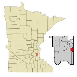 Location of the city of North Saint Paul within Ramsey County, Minnesota | |
| Coordinates: 45°0′46″N 92°59′54″W | |
| Country | United States |
| State | Minnesota |
| County | Ramsey |
| Area | |
| • Total | 3.01 sq mi (7.80 km2) |
| • Land | 2.85 sq mi (7.39 km2) |
| • Water | 0.16 sq mi (0.41 km2) |
| Elevation | 974 ft (297 m) |
| Population | |
| • Total | 11,460 |
| • Estimate (2019)[3] | 12,506 |
| • Density | 4,381.92/sq mi (1,691.62/km2) |
| Time zone | UTC−6 (Central (CST)) |
| • Summer (DST) | UTC−5 (CDT) |
| ZIP Code | 55109 |
| Area code(s) | 651 |
| FIPS code | 27-47221 |
| GNIS feature ID | 0648686[4] |
| Website | City of North Saint Paul |
North Saint Paul is a distinct city, and not a neighborhood of nearby Saint Paul. This fact also contributes to a major difference from typical suburbs; rather than being composed of new developments and urban sprawl, many of the structures in town are older, including a downtown area of brick storefronts.
On the east side of the Margaret Street bridge over Minnesota State Highway 36 resides the 20-ton North Saint Paul Snowman. As the official city logo of North Saint Paul, it was constructed on Margaret and 7th Streets from 1971 to 1974 by Lloyd Koesling and moved to its current location in 1990.[6]
Geography
According to the United States Census Bureau, the city has a total area of 3.01 sq mi (7.80 km2), of which 2.85 sq mi (7.38 km2) is land and 0.16 sq mi (0.41 km2) is water.[7] Silver Lake and Casey Lake are the city's largest bodies of water and both have large, adjacent parks.
Transportation
Minnesota Highway 36 and the Gateway State Trail, running over the former Soo Line Railway grade, bisect the city of North Saint Paul.
Highway 36 serves as a main route in the city; it is a four-lane highway with both at-grade and overpass intersections. Additionally, Interstate Highway 694 is in close proximity to the city.
History
North St. Paul was originally called Castle, and under the latter name was laid out in 1887 by Henry Anson Castle when the Wisconsin Central Railroad was extended to that point.[8]
Demographics
| Historical population | |||
|---|---|---|---|
| Census | Pop. | %± | |
| 1890 | 1,099 | — | |
| 1900 | 1,110 | 1.0% | |
| 1910 | 1,404 | 26.5% | |
| 1920 | 1,979 | 41.0% | |
| 1930 | 2,915 | 47.3% | |
| 1940 | 3,135 | 7.5% | |
| 1950 | 4,248 | 35.5% | |
| 1960 | 8,520 | 100.6% | |
| 1970 | 11,950 | 40.3% | |
| 1980 | 11,921 | −0.2% | |
| 1990 | 12,376 | 3.8% | |
| 2000 | 11,929 | −3.6% | |
| 2010 | 11,460 | −3.9% | |
| Est. 2019 | 12,506 | [3] | 9.1% |
| U.S. Decennial Census[9] | |||
2010 census
As of the census[2] of 2010, there were 11,460 people, 4,615 households, and 2,982 families living in the city. The population density was 4,021.1 inhabitants per square mile (1,552.6/km2). There were 4,822 housing units at an average density of 1,691.9 per square mile (653.2/km2). The racial makeup of the city was 81.2% White, 7.0% African American, 0.6% Native American, 6.6% Asian, 0.1% Pacific Islander, 1.6% from other races, and 2.9% from two or more races. Hispanic or Latino of any race were 4.9% of the population.
There were 4,615 households, of which 30.7% had children under the age of 18 living with them, 46.7% were married couples living together, 12.9% had a female householder with no husband present, 5.0% had a male householder with no wife present, and 35.4% were non-families. Of all households 28.2% were made up of individuals, and 10% had someone living alone who was 65 years of age or older. The average household size was 2.47 and the average family size was 3.04.
The median age in the city was 38.5 years. Of residents 22.7% were under the age of 18; 9.9% were between the ages of 18 and 24; 25.3% were from 25 to 44; 29% were from 45 to 64; and 13.1% were 65 years of age or older. The gender makeup of the city was 49.1% male and 50.9% female.
2000 census
As of the census of 2000, there were 11,929 people, 4,703 households, and 3,160 families living in the city. The population density was 4,132.4 people per square mile (1,593.7/km2). There were 4,753 housing units at an average density of 1,646.5 per square mile (635.0/km2). The racial makeup of the city was 92.86% White, 2.62% African American, 0.55% Native American, 1.68% Asian, 0.03% Pacific Islander, 0.86% from other races, and 1.39% from two or more races. Hispanic or Latino of any race were 2.36% of the population.
There were 4,703 households, out of which 33.3% had children under the age of 18 living with them, 51.6% were married couples living together, 11.5% had a female householder with no husband present, and 32.8% were non-families. Of all households 27.0% were made up of individuals, and 9.9% had someone living alone who was 65 years of age or older. The average household size was 2.52 and the average family size was 3.09.
In the city, the population was spread out, with 26.3% under the age of 18, 8.8% from 18 to 24, 30.6% from 25 to 44, 22.7% from 45 to 64, and 11.7% who were 65 years of age or older. The median age was 36 years. For every 100 females, there were 97.0 males. For every 100 females age 18 and over, there were 91.9 males.
The median income for a household in the city was $50,923, and the median income for a family was $59,652. Males had a median income of $38,958 versus $29,757 for females. The per capita income for the city was $22,411. About 2.2% of families and 4.2% of the population were below the poverty line, including 4.1% of those under age 18 and 3.7% of those age 65 or over.
Religion
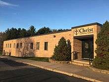
Christ Lutheran Church is a member of the Wisconsin Evangelical Lutheran Synod (WELS) in North St. Paul.
North Church is a Presbyterian congregation in North St. Paul.[10]
Education
Public
- North High School
- Cowern Elementary School
- Richardson Elementary School
- L.C. Webster Elementary School
Private
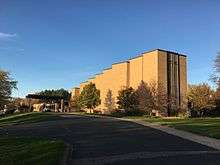
- Christ Lutheran School[11]
- St. Peter Catholic School
References
- "2019 U.S. Gazetteer Files". United States Census Bureau. Retrieved July 26, 2020.
- "U.S. Census website". United States Census Bureau. Retrieved 2012-11-13.
- "Population and Housing Unit Estimates". United States Census Bureau. May 24, 2020. Retrieved May 27, 2020.
- "US Board on Geographic Names". United States Geological Survey. 2007-10-25. Retrieved 2008-01-31.
- "2010 Census Redistricting Data (Public Law 94-171) Summary File". American FactFinder. U.S. Census Bureau, 2010 Census. Retrieved 23 April 2011.
- http://www.startseeingart.com/sculpture/north-st-paul-snowman-by-lloyd-koesling/
- "US Gazetteer files 2010". United States Census Bureau. Archived from the original on 2012-07-02. Retrieved 2012-11-13.
- Upham, Warren (1920). Minnesota Geographic Names: Their Origin and Historic Significance. Minnesota Historical Society. p. 437.
- United States Census Bureau. "Census of Population and Housing". Retrieved August 14, 2013.
- "Contact Us". North Church. Retrieved 13 August 2019.
- Christ Lutheran School
External links
Municipalities and communities of Ramsey County, Minnesota, United States | ||
|---|---|---|
| Cities |  Map of Minnesota highlighting Ramsey County | |
| Township | ||
| Unincorporated communities | ||
| Ghost towns/Neighborhoods | ||
| Footnotes | ‡This populated place also has portions in an adjacent county or counties | |
| Authority control |
|
|---|