National Register of Historic Places listings in Raleigh County, West Virginia
This is a list of the National Register of Historic Places listings in Raleigh County, West Virginia.
This is intended to be a complete list of the properties and districts on the National Register of Historic Places in Raleigh County, West Virginia, United States. The locations of National Register properties and districts for which the latitude and longitude coordinates are included below, may be seen in an online map.[1]
There are 9 properties and districts listed on the National Register in the county.
- This National Park Service list is complete through NPS recent listings posted August 14, 2020.[2]
Barbour - Berkeley - Boone - Braxton - Brooke - Cabell - Calhoun - Clay - Doddridge - Fayette - Gilmer - Grant - Greenbrier - Hampshire - Hancock - Hardy - Harrison - Jackson - Jefferson - Kanawha - Lewis - Lincoln - Logan - Marion - Marshall - Mason - McDowell - Mercer - Mineral - Mingo - Monongalia - Monroe - Morgan - Nicholas - Ohio - Pendleton - Pleasants - Pocahontas - Preston - Putnam - Raleigh - Randolph - Ritchie - Roane - Summers - Taylor - Tucker - Tyler - Upshur - Wayne - Webster - Wetzel - Wirt - Wood - Wyoming |
Current listings
| [3] | Name on the Register | Image | Date listed[4] | Location | City or town | Description |
|---|---|---|---|---|---|---|
| 1 | Beckley Courthouse Square Historic District | 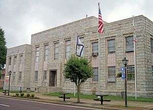 Beckley Courthouse Square Historic District |
August 31, 1994 (#94000722) |
Roughly bounded by Prince, Kanawha, Church, Lebanon, Howe, McCreery and Earwood Sts. and Alaska and First Aves. 37°46′36″N 81°11′16″W |
Beckley | |
| 2 | Beckley Feed and Hardware Company | 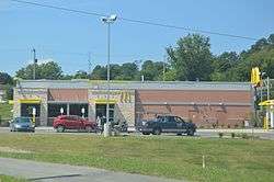 Beckley Feed and Hardware Company |
August 24, 2001 (#00001309) |
405 Prince St. 37°46′36″N 81°11′38″W |
Beckley | Demolished in 2013.[5] |
| 3 | Beckley Mill Site | May 1, 2017 (#100000947) |
Worley Rd. at Piney Cr. 37°46′24″N 81°09′03″W |
Beckley | ||
| 4 | Little Beaver Dam |  Little Beaver Dam |
April 1, 1998 (#98000287) |
Little Beaver State Park off WV 307 37°45′18″N 81°04′48″W |
Crow | |
| 5 | Phillips-Sprague Mine | 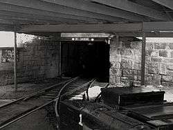 Phillips-Sprague Mine |
March 25, 1988 (#88000266) |
New River Park[6] 37°47′03″N 81°11′46″W |
Beckley | |
| 6 | St. Colman's Roman Catholic Church and Cemetery | 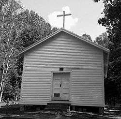 St. Colman's Roman Catholic Church and Cemetery |
August 23, 1984 (#84003658) |
County Route 26 37°45′57″N 80°55′16″W |
Dillon | |
| 7 | Sophia Historic District | 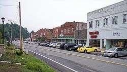 Sophia Historic District |
March 22, 2006 (#06000163) |
Main St., between Polk St. and Riffe St. 37°42′34″N 81°15′07″W |
Sophia | |
| 8 | Trump-Lilly Farmstead | 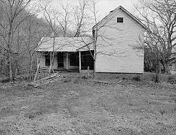 Trump-Lilly Farmstead |
November 8, 1990 (#90001640) |
County Route 26/3, 2.5 miles from County Route 26 37°41′54″N 80°54′01″W |
Hinton | |
| 9 | Wildwood | 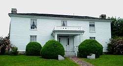 Wildwood |
August 25, 1970 (#70000665) |
117 Laurel Ter. 37°46′18″N 81°10′26″W |
Beckley |
See also
| Wikimedia Commons has media related to National Register of Historic Places in Raleigh County, West Virginia. |
References
- The latitude and longitude information provided in this table was derived originally from the National Register Information System, which has been found to be fairly accurate for about 99% of listings. Some locations in this table may have been corrected to current GPS standards.
- "National Register of Historic Places: Weekly List Actions". National Park Service, United States Department of the Interior. Retrieved on August 14, 2020.
- Numbers represent an ordering by significant words. Various colorings, defined here, differentiate National Historic Landmarks and historic districts from other NRHP buildings, structures, sites or objects.
- The eight-digit number below each date is the number assigned to each location in the National Register Information System database, which can be viewed by clicking the number.
- http://www.register-herald.com/todaysfrontpage/x1566987885/Beckley-Feed-and-Hardware-being-demolished
- Lois C. McLean and Rodney S. Collins (February 1988). "National Register of Historic Places Inventory Nomination Form: Phillips-Sprague Mine" (PDF). State of West Virginia, West Virginia Division of Culture and History, Historic Preservation. p. 1. Retrieved 2011-07-09.
| Topics | ||
|---|---|---|
| Lists by county |
| |
| Other lists | ||
| ||