National Register of Historic Places listings in Marion County, West Virginia
This is a list of the National Register of Historic Places listings in Marion County, West Virginia.

This is intended to be a complete list of the properties and districts on the National Register of Historic Places in Marion County, West Virginia, United States. The locations of National Register properties and districts for which the latitude and longitude coordinates are included below, may be seen in a Google map.[1]
There are 22 properties and districts listed on the National Register in the county.
- This National Park Service list is complete through NPS recent listings posted August 14, 2020.[2]
Barbour - Berkeley - Boone - Braxton - Brooke - Cabell - Calhoun - Clay - Doddridge - Fayette - Gilmer - Grant - Greenbrier - Hampshire - Hancock - Hardy - Harrison - Jackson - Jefferson - Kanawha - Lewis - Lincoln - Logan - Marion - Marshall - Mason - McDowell - Mercer - Mineral - Mingo - Monongalia - Monroe - Morgan - Nicholas - Ohio - Pendleton - Pleasants - Pocahontas - Preston - Putnam - Raleigh - Randolph - Ritchie - Roane - Summers - Taylor - Tucker - Tyler - Upshur - Wayne - Webster - Wetzel - Wirt - Wood - Wyoming |
Current listings
| [3] | Name on the Register | Image | Date listed[4] | Location | City or town | Description |
|---|---|---|---|---|---|---|
| 1 | Barrackville Covered Bridge | 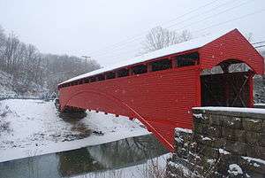 Barrackville Covered Bridge |
March 30, 1973 (#73001921) |
County Route 21 over Buffalo Creek 39°30′21″N 80°10′05″W |
Barrackville | |
| 2 | Colonial Apartments | 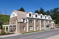 Colonial Apartments |
July 26, 2006 (#06000653) |
2 E. Garden Ln. 39°29′00″N 80°09′54″W |
Fairmont | |
| 3 | Dunbar School | .jpg) Dunbar School |
April 28, 2015 (#15000188) |
103 High St. 39°29′12″N 80°08′48″W |
Fairmont | |
| 4 | Fairmont Downtown Historic District |  Fairmont Downtown Historic District |
August 15, 1995 (#95001008) |
Along Jackson, Adams, Washington and Quincy Sts. and Cleveland and Fairmont Aves. 39°28′57″N 80°08′39″W |
Fairmont | |
| 5 | Fairmont Normal School Administration Building | 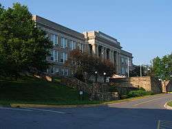 Fairmont Normal School Administration Building |
March 28, 1994 (#94000216) |
Junction of Locust Ave. and Bryant St. 39°28′59″N 80°09′37″W |
Fairmont | |
| 6 | Fairmont Senior High School | 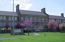 Fairmont Senior High School |
March 22, 2002 (#02000254) |
1 Loop Park 39°28′43″N 80°09′26″W |
Fairmont | |
| 7 | Thomas W. Fleming House | 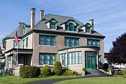 Thomas W. Fleming House |
August 29, 1979 (#79002587) |
300 1st St. 39°28′53″N 80°08′41″W |
Fairmont | |
| 8 | Fleming-Watson Historic District | 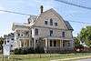 Fleming-Watson Historic District |
November 29, 2001 (#01001330) |
Approximately bounded by Fairmont Ave., Second, Fay Sts., Apple Ct, Green, Emerson Sts., Coleman Ave., Seventh St., Outlook 39°29′N 80°09′W |
Fairmont | |
| 9 | Hamilton Round Barn | 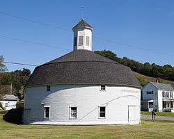 Hamilton Round Barn |
July 9, 1985 (#85001548) |
County Route 11 39°30′59″N 80°20′16″W |
Mannington | |
| 10 | High Gate |  High Gate |
April 15, 1982 (#82004326) |
801 Fairmont Ave. 39°28′29″N 80°09′10″W |
Fairmont | |
| 11 | High Level Bridge | 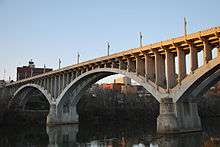 High Level Bridge |
December 4, 1991 (#91001734) |
Jefferson St. across the Monongahela River 39°28′57″N 80°08′27″W |
Fairmont | |
| 12 | Jacobs-Hutchinson Block | 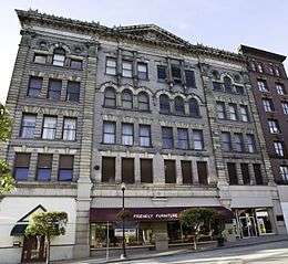 Jacobs-Hutchinson Block |
July 21, 1995 (#95000874) |
201-209 Adams St. 39°29′05″N 80°08′38″W |
Fairmont | |
| 13 | Mannington Historic District | 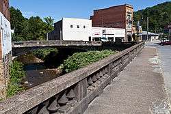 Mannington Historic District |
November 22, 1995 (#95001313) |
Roughly bounded by High, Clarksburg and Howard Sts. and Buffalo Creek 39°31′44″N 80°20′39″W |
Mannington | |
| 14 | Marion County Courthouse and Sheriff's House |  Marion County Courthouse and Sheriff's House |
May 29, 1979 (#79003149) |
Adams and Jefferson Sts. 39°29′06″N 80°08′37″W |
Fairmont | |
| 15 | Masonic Temple |  Masonic Temple |
April 9, 1993 (#93000218) |
320 Jefferson St. 39°29′08″N 80°08′34″W |
Fairmont | |
| 16 | Thomas C. Miller Public School | 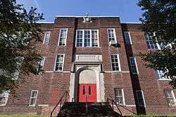 Thomas C. Miller Public School |
May 8, 2013 (#13000263) |
2 Pennsylvania Ave. 39°29′20″N 80°08′30″W |
Fairmont | |
| 17 | George Pinkney Morgan House | 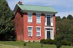 George Pinkney Morgan House |
May 1, 2003 (#03000348) |
County Route 19/3 39°32′01″N 80°05′42″W |
Rivesville | |
| 18 | Prickett's Fort |  Prickett's Fort |
February 13, 1974 (#74002404) |
Address Restricted; located at Prickett's Fort State Park 39°30′55″N 80°05′53″W |
Fairmont | |
| 19 | Jacob Prickett, Jr. Log House | 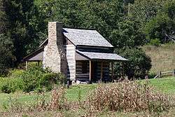 Jacob Prickett, Jr. Log House |
April 20, 1979 (#79002588) |
South of Montana off County Route 72 39°31′07″N 80°06′01″W |
Montana | |
| 20 | Shaw House | Shaw House |
September 14, 1988 (#88001461) |
425 Morgantown Ave. 39°28′50″N 80°07′56″W |
Fairmont | |
| 21 | Wilson School | 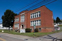 Wilson School |
November 29, 2001 (#01001331) |
917 E. Main St. 39°31′32″N 80°20′05″W |
Mannington | |
| 22 | Woodlawn Cemetery |  Woodlawn Cemetery |
April 14, 2004 (#04000305) |
335 Maple Ave. 39°29′37″N 80°08′14″W |
Fairmont |
See also
| Wikimedia Commons has media related to National Register of Historic Places in Marion County, West Virginia. |
References
- The latitude and longitude information provided in this table was derived originally from the National Register Information System, which has been found to be fairly accurate for about 99% of listings. Some locations in this table may have been corrected to current GPS standards.
- "National Register of Historic Places: Weekly List Actions". National Park Service, United States Department of the Interior. Retrieved on August 14, 2020.
- Numbers represent an ordering by significant words. Various colorings, defined here, differentiate National Historic Landmarks and historic districts from other NRHP buildings, structures, sites or objects.
- The eight-digit number below each date is the number assigned to each location in the National Register Information System database, which can be viewed by clicking the number.
| Topics | ||
|---|---|---|
| Lists by county |
| |
| Other lists | ||
| ||
Municipalities and communities of Marion County, West Virginia, United States | ||
|---|---|---|
| Cities | Marion County map | |
| Towns | ||
| CDPs | ||
| Unincorporated communities |
| |
| Fictional places | ||
| Footnotes | ‡This populated place also has portions in an adjacent county or counties | |