National Register of Historic Places listings in Cumberland County, Virginia
This is a list of the National Register of Historic Places listings in Cumberland County, Virginia.
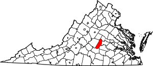
Location of Cumberland County in Virginia
This is intended to be a complete list of the properties and districts on the National Register of Historic Places in Cumberland County, Virginia, United States. The locations of National Register properties and districts for which the latitude and longitude coordinates are included below, may be seen in an online map.[1]
There are 17 properties and districts listed on the National Register in the county.
- This National Park Service list is complete through NPS recent listings posted August 14, 2020.[2]
Current listings
| [3] | Name on the Register[4] | Image | Date listed[5] | Location | City or town | Description |
|---|---|---|---|---|---|---|
| 1 | Ampthill |  Ampthill |
April 13, 1972 (#72001389) |
Western side of Ampthill Rd., 3 miles (4.8 km) north of the junction with State Route 45 37°41′50″N 78°06′15″W |
Cartersville | |
| 2 | Bear Creek Lake State Park | .jpg) Bear Creek Lake State Park |
October 31, 2012 (#12000904) |
22 Bear Creek Lake Rd. 37°31′56″N 78°16′36″W |
Cumberland | |
| 3 | Cartersville Bridge |  Cartersville Bridge |
September 14, 1972 (#72001390) |
State Route 45 over James River 37°40′13″N 78°05′13″W |
Cartersville | Extends into Goochland County |
| 4 | Cartersville Historic District |  Cartersville Historic District |
June 10, 1993 (#93000505) |
Roughly bounded by State Route 45, High St., and Church Rd. 37°40′01″N 78°05′24″W |
Cartersville | |
| 5 | Clifton |  Clifton |
June 19, 1973 (#73002007) |
North of Hamilton off Columbia Rd. 37°40′42″N 78°07′38″W |
Hamilton | |
| 6 | Cumberland County Courthouse |  Cumberland County Courthouse |
September 30, 1994 (#94001178) |
Northern side of U.S. Route 60 at its junction with Stoney Point Rd. 37°29′49″N 78°14′41″W |
Cumberland | |
| 7 | Cumberland Court House Historic District |  Cumberland Court House Historic District |
August 16, 2007 (#07000829) |
U.S. Route 60 at its junction with Stoney Point Rd. 37°29′46″N 78°14′42″W |
Cumberland | |
| 8 | Grace Church |  Grace Church |
October 30, 1980 (#80004185) |
West of Cumberland on Caira Rd. 37°29′01″N 78°19′43″W |
Ca Ira | |
| 9 | Hamilton High School |  Hamilton High School |
October 31, 2007 (#07001136) |
1925 Cartersville Rd. 37°39′29″N 78°07′35″W |
Cartersville | |
| 10 | High Bridge | 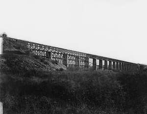 High Bridge |
September 12, 2008 (#08000875) |
Appomattox River 37°18′45″N 78°19′13″W |
Farmville | Extends into Prince Edward County |
| 11 | Morven |  Morven |
December 28, 1990 (#90002014) |
State Route 45, 0.5 miles (0.80 km) south of Cartersville 37°39′34″N 78°05′56″W |
Cartersville | |
| 12 | Muddy Creek Mill |  Muddy Creek Mill |
October 9, 1974 (#74002114) |
South of Cartersville off Cartersville Rd. 37°38′55″N 78°04′50″W |
Tamworth | |
| 13 | Needham |  Needham |
November 10, 1988 (#88002059) |
State Route 45, 1.4 miles (2.3 km) north of the junction with U.S. Route 460 37°19′21″N 78°23′07″W |
Farmville | |
| 14 | Oak Hill |  Oak Hill |
July 27, 2005 (#05000764) |
181 Oak Hill Rd. 37°29′31″N 78°18′52″W |
Cumberland | |
| 15 | Pine Grove Elementary School | February 25, 2020 (#100005010) |
267 Pinegrove Rd. 37°33′47″N 78°07′58″W |
Cumberland vicinity | ||
| 16 | Charles Irving Thornton Tombstone |  Charles Irving Thornton Tombstone |
November 25, 1980 (#80004186) |
West of Cumberland, off Oak Hill Forest Rd. 37°29′37″N 78°18′52″W |
Cumberland | |
| 17 | Trenton |  Trenton |
July 27, 2005 (#05000765) |
751 Oak Hill Rd. 37°31′39″N 78°17′07″W |
Cumberland |
See also
| Wikimedia Commons has media related to National Register of Historic Places in Cumberland County, Virginia. |
References
- The latitude and longitude information provided in this table was derived originally from the National Register Information System, which has been found to be fairly accurate for about 99% of listings. Some locations in this table may have been corrected to current GPS standards.
- "National Register of Historic Places: Weekly List Actions". National Park Service, United States Department of the Interior. Retrieved on August 14, 2020.
- Numbers represent an ordering by significant words. Various colorings, defined here, differentiate National Historic Landmarks and historic districts from other NRHP buildings, structures, sites or objects.
- "National Register Information System". National Register of Historic Places. National Park Service. April 24, 2008.
- The eight-digit number below each date is the number assigned to each location in the National Register Information System database, which can be viewed by clicking the number.
Municipalities and communities of Cumberland County, Virginia, United States | ||
|---|---|---|
| Town | Map of Virginia highlighting Cumberland County | |
| CDP | ||
| Unincorporated communities | ||
| Footnotes | ‡This populated place also has portions in an adjacent county or counties | |
This article is issued from Wikipedia. The text is licensed under Creative Commons - Attribution - Sharealike. Additional terms may apply for the media files.