National Register of Historic Places listings in Chatham County, North Carolina
This list includes properties and districts listed on the National Register of Historic Places in Chatham County, North Carolina. Click the "Map of all coordinates" link to the right to view a Google map of all properties and districts with latitude and longitude coordinates in the table below.[1]

Current listings
- This National Park Service list is complete through NPS recent listings posted August 14, 2020.[2]
| [3] | Name on the Register[4] | Image | Date listed[5] | Location | City or town | Description |
|---|---|---|---|---|---|---|
| 1 | Alston-DeGraffenried House | November 18, 1974 (#74001339) |
West of Pittsboro off U.S. Route 64; also the northern side of U.S. Route 64, 0.4 miles (0.64 km) west of its junction with NC 1564 35°43′51″N 79°14′38″W |
Pittsboro | Second set of boundaries represents a boundary increase of October 21, 1993, the Alston-DeGraffenried Plantation | |
| 2 | Aspen Hall | July 29, 1982 (#82003441) |
West of Pittsboro on U.S. Route 64 35°44′02″N 79°16′24″W |
Pittsboro | ||
| 3 | Baldwin's Mill | 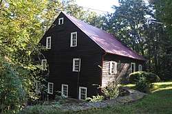 Baldwin's Mill |
January 2, 1986 (#86000007) |
SR 1520 35°49′35″N 79°14′04″W |
Pittsboro | |
| 4 | Bowen-Jordan Farm | July 5, 1985 (#85001451) |
SR 1100 35°40′51″N 79°30′30″W |
Siler City | ||
| 5 | Cadmus N. Bray House | December 30, 1999 (#99001620) |
229 W. Second St. 35°43′25″N 79°27′42″W |
Siler City | ||
| 6 | Bray-Paschal House | December 27, 2011 (#11000973) |
2488 Wade Paschal Rd. 35°40′59″N 79°29′15″W |
Siler City | ||
| 7 | Sheriff Stephen Wiley Brewer Farmstead | 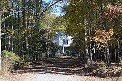 Sheriff Stephen Wiley Brewer Farmstead |
August 21, 2003 (#03000801) |
365 Thompson St. 35°43′26″N 79°10′13″W |
Pittsboro | |
| 8 | Bynum Bridge | April 23, 2020 (#100005196) |
Old Bynum Road, connecting SR 1871 and SR 1713 over Haw River 35°46′18″N 79°08′42″W |
Bynum | ||
| 9 | Chatham County Courthouse | 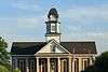 Chatham County Courthouse |
May 10, 1979 (#79001691) |
NC 15-501 and U.S. Route 64 35°43′12″N 79°10′39″W |
Pittsboro | |
| 10 | Luther Clegg House | 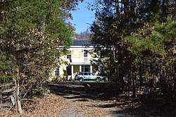 Luther Clegg House |
October 5, 1982 (#82001283) |
South of Pittsboro on Moncure Pittsboro Rd. 35°41′55″N 79°09′48″W |
Pittsboro | |
| 11 | Deep River Camelback Truss Bridge | Deep River Camelback Truss Bridge |
June 9, 1995 (#95000696) |
Adjacent to NC 2153 over the Deep River 35°34′13″N 79°14′28″W |
Cumnock and Gulf | |
| 12 | DeGraffenreidt-Johnson House | July 5, 1985 (#85001452) |
SR 1346 35°46′37″N 79°18′15″W |
Silk Hope | ||
| 13 | East Raleigh Street Historic District | May 11, 2000 (#00000488) |
300-400 blocks of E. Second St., and 300-600 blocks of E. Raleigh St. 35°43′30″N 79°27′32″W |
Siler City | ||
| 14 | Ebenezer Methodist Church | 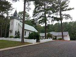 Ebenezer Methodist Church |
July 5, 1985 (#85001450) |
SR 1008 35°43′37″N 79°00′23″W |
Bells | |
| 15 | Former High Point Bending and Chair Company | November 12, 1999 (#99001332) |
108 W. 3rd St. 35°43′33″N 79°28′01″W |
Siler City | ||
| 16 | Lewis Freeman House | 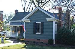 Lewis Freeman House |
October 5, 1982 (#82001284) |
205 W. Salisbury St. 35°43′18″N 79°10′48″W |
Pittsboro | |
| 17 | Goldston Commercial Historic District | November 25, 1987 (#87002014) |
Roughly S. Bellevue and S. Main Sts. between W. Goldbar and Colonial Sts. 35°35′33″N 79°19′41″W |
Goldston | ||
| 18 | Goodwin Farm Complex | July 5, 1985 (#85001453) |
SR 1900 35°43′11″N 78°57′37″W |
Bells | ||
| 19 | Gregson-Hadley House | July 5, 1985 (#85001454) |
322 E. Raleigh St. 35°43′27″N 79°27′34″W |
Siler City | ||
| 20 | Hadley House and Grist Mill | November 25, 1980 (#80002807) |
Northwest of Pittsboro on SR 2165 35°42′32″N 79°18′02″W |
Pittsboro | ||
| 21 | Hall-London House | 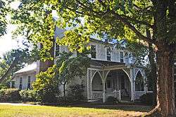 Hall-London House |
October 5, 1982 (#82001285) |
206 Hillsboro St. 35°43′19″N 79°10′37″W |
Pittsboro | |
| 22 | Haughton-McIver House | July 5, 1985 (#85001455) |
SR 1007 35°33′26″N 79°17′05″W |
Gulf | ||
| 23 | Hotel Hadley | July 5, 1985 (#85001456) |
103 N. Chatham St. 35°43′24″N 79°27′49″W |
Siler City | ||
| 24 | Marion Jasper Jordan Farm | February 25, 1988 (#88000169) |
R. Jordan Rd./SR 2145 35°33′27″N 79°16′13″W |
Gulf | ||
| 25 | Kelvin | October 5, 1982 (#82001286) |
503 W. Salisbury St. 35°43′16″N 79°11′02″W |
Pittsboro | Destroyed[6] | |
| 26 | Lockville Dam, Canal and Powerhouse | .jpg) Lockville Dam, Canal and Powerhouse |
November 20, 1984 (#84000305) |
West of Moncure at Deep River and U.S. Route 1 35°37′10″N 79°05′45″W |
Moncure | |
| 27 | London Cottage | 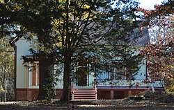 London Cottage |
October 5, 1982 (#82001287) |
North of Pittsboro on Old Graham Rd. 35°43′38″N 79°11′12″W |
Pittsboro | |
| 28 | Henry Adolphus London House | 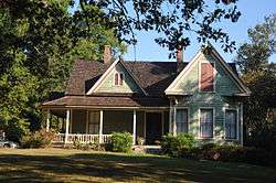 Henry Adolphus London House |
September 3, 1998 (#98001143) |
440 W. Salisbury St. 35°43′21″N 79°11′07″W |
Pittsboro | |
| 29 | John A. Mason House | October 23, 1974 (#74001338) |
Southwest of Durham off NC 751 35°49′31″N 78°59′38″W |
Farrington | ||
| 30 | McClenahan House |  McClenahan House |
October 5, 1982 (#82001288) |
Address Restricted |
Pittsboro | The house has been moved within Pittsboro |
| 31 | Robert Joseph Moore House |  Robert Joseph Moore House |
September 3, 1998 (#98001142) |
Bynum Rd. at its junction with Bynum Ridge Rd. 35°46′43″N 79°07′59″W |
Bynum | |
| 32 | Moore-Manning House | October 5, 1982 (#82001289) |
400 Hillsboro St. 35°43′32″N 79°10′35″W |
Pittsboro | ||
| 33 | Mount Vernon Springs Historic District | December 3, 1987 (#87002045) |
SR 1134 and 1135 35°39′32″N 79°26′38″W |
Bonlee | ||
| 34 | New Hope Rural Historical Archeological District | February 25, 1985 (#85000382) |
Address Restricted |
Wilsonville | ||
| 35 | Newkirk Site (Site 31CH366) | November 14, 1983 (#83003813) |
Address Restricted |
Moncure | ||
| 36 | North Third Avenue Historic District | July 20, 2000 (#00000824) |
Roughly bounded by N. Second Ave., E. Fourth St., N. Third Ave., and E. Third St. 35°43′34″N 79°27′47″W |
Siler City | ||
| 37 | O'Kelly's Chapel | 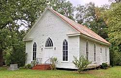 O'Kelly's Chapel |
July 5, 1985 (#85001457) |
NC 751 35°51′56″N 78°56′41″W |
Farrington | |
| 38 | Paschal-Womble House | April 26, 1984 (#84001957) |
421 Main St. 35°35′40″N 79°19′44″W |
Goldston | ||
| 39 | Pittsboro Historic District | 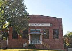 Pittsboro Historic District |
May 5, 2000 (#00000442) |
Roughly bounded by Chatham St., Small St., Rectory St., and Launis St. 35°43′21″N 79°10′36″W |
Pittsboro | |
| 40 | Pittsboro Masonic Lodge | 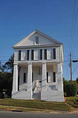 Pittsboro Masonic Lodge |
January 31, 1978 (#78001938) |
East and Masonic Sts. 35°43′13″N 79°10′32″W |
Pittsboro | |
| 41 | Pittsboro Presbyterian Church |  Pittsboro Presbyterian Church |
January 30, 1978 (#78001939) |
N. East St. 35°43′13″N 79°10′34″W |
Pittsboro | |
| 42 | Reid House | 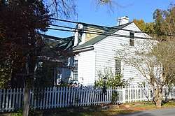 Reid House |
October 5, 1982 (#82001290) |
200 W. Salisbury St. 35°43′19″N 79°10′45″W |
Pittsboro | |
| 43 | William Alston Rives House | July 5, 1985 (#85001459) |
End of SR 2183 off SR 2187 35°37′24″N 79°18′22″W |
Goldston | ||
| 44 | Siler City City Hall | October 30, 1998 (#98001302) |
311 N. Second Ave. 35°43′31″N 79°27′52″W |
Siler City | ||
| 45 | Siler City Commercial Historic District | 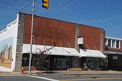 Siler City Commercial Historic District |
July 27, 2000 (#00000841) |
Roughly bounded by Second Ave., Birch Ave., Third St. and Beaver St. 35°43′23″N 79°27′50″W |
Siler City | |
| 46 | Siler City High School | July 15, 1998 (#98000873) |
119 S. Third Ave. 35°43′23″N 79°27′36″W |
Siler City | ||
| 47 | Snipes-Fox House | September 3, 1998 (#98001144) |
306 S. Dogwood Ave. 35°43′08″N 79°28′00″W |
Siler City | ||
| 48 | Patrick St. Lawrence House | 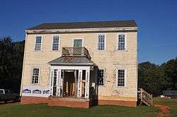 Patrick St. Lawrence House |
October 5, 1982 (#82001291) |
Address Restricted |
Pittsboro | Moved adjacent to the McClenahan House |
| 49 | Joseph B. Stone House | 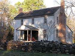 Joseph B. Stone House |
June 1, 1982 (#82003440) |
SR 1008 35°46′47″N 79°00′25″W |
Farrington | |
| 50 | William Teague House | July 5, 1985 (#85001458) |
SR 1004 35°46′24″N 79°26′41″W |
Siler City | ||
| 51 | A.P. Terry House | 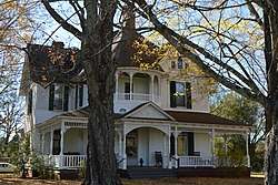 A.P. Terry House |
October 5, 1982 (#82001292) |
601 Womack St. 35°43′05″N 79°11′08″W |
Pittsboro | |
| 52 | James A. Thomas Farm | July 5, 1985 (#85001460) |
SR 1941 35°42′21″N 79°04′43″W |
Pittsboro | ||
| 53 | Dr. E. H. Ward Farm | 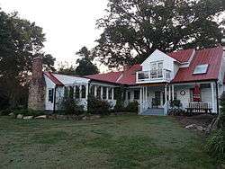 Dr. E. H. Ward Farm |
July 5, 1985 (#85001461) |
SR 1700 35°46′44″N 79°05′47″W |
Bynum | 19th century homestead of a traveling physician, Dr. Edward Hiram Ward (August 1829 – June 1896) was the son of Hiram Ward (1794–1842) and Sara Hackney (1806–1848) and lived in Chatham County, North Carolina. Private residence, outdoor wedding and event location venue - Ward's Hollow. |
| 54 | Whitehead-Fogleman Farm | July 5, 1985 (#85001462) |
Junction of SR 1351 and 1352 35°50′01″N 79°27′20″W |
Crutchfield Crossroads | ||
| 55 | Burdett Woody House | August 6, 2008 (#08000773) |
2232 White Smith Rd. 35°48′25″N 79°18′50″W |
Siler City |
Former listing
| [3] | Name on the Register | Image | Date listed | Date removed | Location | City or town | Summary |
|---|---|---|---|---|---|---|---|
| 1 | Ebenezer Log Church | November 19, 1974 (#74001340) | Unknown | Address Restricted 35°48′25″N 79°18′50″W |
Pittsboro |
See also
| Wikimedia Commons has media related to National Register of Historic Places in Chatham County, North Carolina. |
References
- The latitude and longitude information provided in this table was derived originally from the National Register Information System, which has been found to be fairly accurate for about 99% of listings. Some locations in this table may have been corrected to current GPS standards.
- "National Register of Historic Places: Weekly List Actions". National Park Service, United States Department of the Interior. Retrieved on August 14, 2020.
- Numbers represent an ordering by significant words. Various colorings, defined here, differentiate National Historic Landmarks and historic districts from other NRHP buildings, structures, sites or objects.
- "National Register Information System". National Register of Historic Places. National Park Service. April 24, 2008.
- The eight-digit number below each date is the number assigned to each location in the National Register Information System database, which can be viewed by clicking the number.
- "North Carolina Listings in the National Register of Historic Places by County". North Carolina State Historic Preservation Office. 22 October 2008. Archived from the original on 30 November 2012. Retrieved 14 July 2009.
| Topics | |
|---|---|
| Lists by state |
|
| Lists by insular areas | |
| Lists by associated state | |
| Other areas | |
| Related | |
| |
Municipalities and communities of Chatham County, North Carolina, United States | ||
|---|---|---|
| Towns | | |
| CDPs | ||
| Unincorporated communities | ||
| Footnotes | ‡This populated place also has portions in an adjacent county or counties | |
This article is issued from Wikipedia. The text is licensed under Creative Commons - Attribution - Sharealike. Additional terms may apply for the media files.