Mourne Mountains
The Mourne Mountains (/mɔːrn/ MORN; Irish: na Beanna Boirche), also called the Mournes or Mountains of Mourne, are a granite mountain range in County Down in the south-east of Northern Ireland.[1] It includes some the highest mountains in Northern Ireland, including Slieve Donard at 850 m (2,790 ft).[2] The Mournes is designated an Area of Outstanding Natural Beauty (AONB)[3] and in 2002 the Environment and Heritage Service commissioned a study on the potential benefits of establishing the Mournes as one of the first national parks in Northern Ireland,[4] though this is yet to occur. The area is partly owned by the National Trust and sees many visitors every year.[5] The name Mourne (historically spelt Morne) is derived from the name of a Gaelic clann or sept called the Múghdhorna.[6][7]
| Mourne Mountains / na Beanna Boirche | |
|---|---|
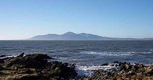 View of the Mournes from St John's Point, County Down | |
| Highest point | |
| Peak | Slieve Donard |
| Elevation | 850 m (2,790 ft) |
| Geography | |
  | |
| Sovereign state | United Kingdom |
| Constituent country | Northern Ireland |
| Counties | County Down |
| Range coordinates | 54°10′N 6°05′W |
| Geology | |
| Type of rock | Granite |
The Mountains
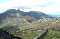
Following a fundraising drive in 1993, the National Trust purchased nearly 5.3 km2 (1,300 acres) of land in the Mournes, which included a part of Slieve Donard (at 850 m (2,790 ft)) and nearby Slieve Commedagh (at 767 m (2,516 ft)), the second-highest mountain in the area.[8]
Some of the mountains have names beginning "Slieve", such as Slieve Donard, Slieve Lamagan and Slieve Muck, which is derived from the Irish word sliabh, meaning "mountain".[9] There are also a number of curious names: Pigeon Rock; Buzzard's Roost; Brandy Pad; the Cock and Hen; Percy Bysshe; the Devil's Coach Road; and Pollaphuca.[10] "Pollaphuca" is derived from the words "Poll", meaning "hole"[11] and "púca", which means ghost or spirit.[12]
The Mournes are very popular as a destination for completing expeditions as required for completing the Duke of Edinburgh's Award.[13] However, there are also a number of walking challenges which take place in the Mournes. The Mourne Wall challenge, which is also referred to as the 7-peak challenge because it takes into account 7 of the 10 highest Mourne mountains, is advertised by WalkNI.[14] The Mourne six peak challenge is advertised by DiscoverNI and takes hikers up Slieve Donard, Commedagh, Bearnagh, Slieve Binnian, Slieve Meelmore and Slieve Meelbeg across three days of hiking.[15]
On clear days, The Mourne Mountains can be seen from the Isle of Man[16] and Dublin.[17]
| Rank | Name | Irish name | Translation[lower-alpha 2] | Elevation[lower-alpha 3] | Prominence[lower-alpha 4] |
|---|---|---|---|---|---|
| 1 | Slieve Donard* Highest in Ulster | Sliabh Dónairt | peak (St.) Domhangart | 850 m (2,790 ft) | 822 m (2,697 ft) |
| 2 | Slieve Commedagh* | Sliabh Coimhéideach | guarding mountain | 767 m (2,516 ft) | 180 m (590 ft) |
| 3 | Slieve Binnian* | Sliabh Binneáin | mountain of small peak | 747 m (2,451 ft) | 282 m (925 ft) |
| 4 | Slieve Bearnagh* | Sliabh Bearnach | gapped mountain | 739 m (2,425 ft) | 304 m (997 ft) |
| 5 | Slieve Meelbeg* | Sliabh Míol Beag | mountain of ants | 708 m (2,323 ft) | 193 m (633 ft) |
| 6 | Slievelamagan* | Sliabh Lámhagáin | creeping mountain | 704 m (2,310 ft) | 197 m (646 ft) |
| 7 | Slieve Meelmore* | Sliabh Míol Mór | mountain of ants | 680 m (2,230 ft) | 109 m (358 ft) |
| 8 | Slieve Muck* | Unknown | Unknown | 673 m (2,208 ft) | 155 m (509 ft) |
| 9 | Slieve Muck* | Sliabh Muc | mountain of the pigs | 670 m (2,200 ft) | 155 m (509 ft) |
| 10 | Chimney Rock Mtn* | Sliabh an Aoire | Shepherd mountain | 656 m (2,152 ft) | 131 m (430 ft) |
| 11 | Cove Mountain | Unknown | Unknown | 655 m (2,149 ft) | 100 m (330 ft) |
| 12 | Slieve Corragh | Unknown | Unknown | 640 m (2,100 ft) | 15 m (49 ft) |
| 13 | Eagle Mountain | Unknown | Unknown | 638 m (2,093 ft) | 263 m (863 ft) |
| 14 | Shanlieve | Unknown | Unknown | 627 m (2,057 ft) | 31 m (102 ft) |
| 15 | Slieve Loughshannagh | Unknown | Unknown | 620 m (2,030 ft) | 104 m (341 ft) |
| 16 | Slieve Beg | Unknown | Unknown | 595 m (1,952 ft) | 41 m (135 ft) |
| 17 | Doan | Unknown | Unknown | 593 m (1,946 ft) | 119 m (390 ft) |
| 18 | Carn Mountain | Unknown | Unknown | 588 m (1,929 ft) | 50 m (160 ft) |
| 19 | Slievenaglogh II | Unknown | Unknown | 586 m (1,923 ft) | 41 m (135 ft) |
| 20 | Finlieve | Unknown | Unknown | 579 m (1,900 ft) | Unknown |
| 21 | Slievemoughanmore | Unknown | Unknown | 560 m (1,840 ft) | 154 m (505 ft) |
| 22 | Crossone | Unknown | Unknown | 544 m (1,785 ft) | Unknown |
| 23 | Pigeon Rock Mountain | Unknown | Unknown | 536 m (1,759 ft) | 139 m (456 ft) |
| 24 | Annalong Buttress | Unknown | Unknown | 530 m (1,740 ft) | Unknown |
| 25 | Ben Crom | Unknown | Unknown | 526 m (1,726 ft) | 81 m (266 ft) |
| 26 | Ott Mountain | Unknown | Unknown | 525 m (1,722 ft) | 32 m (105 ft) |
| 27 | Blaeberry Mountain | Unknown | Unknown | 520 m (1,710 ft) | Unknown |
| 28 | Spences Mountain | Unknown | Unknown | 517 m (1,696 ft) | Unknown |
| 29 | Butter Mountain | Unknown | Unknown | 505 m (1,657 ft) | 95 m (312 ft) |
| 30 | Cock Mountain | Unknown | Unknown | 504 m (1,654 ft) | 130 m (430 ft) |
| 31 | Slievemartin | Unknown | Unknown | 485 m (1,591 ft) | Unknown |
| 32 | Spaltha | Unknown | Unknown | 479 m (1,572 ft) | Unknown |
| 33 | Thomas Mountain | Unknown | Unknown | 475 m (1,558 ft) | Unknown |
| 34 | Tievedockdarragh | Unknown | Unknown | 473 m (1,552 ft) | Unknown |
| 35 | Spelga | Unknown | Unknown | 472 m (1,549 ft) | Unknown |
| 36 | Slievemeen | Unknown | Unknown | 471 m (1,545 ft) | Unknown |
| 37 | Pierces Castle | Unknown | Unknown | 465 m (1,526 ft) | Unknown |
| 38 | Crenville | Unknown | Unknown | 460 m (1,510 ft) | Unknown |
| 39 | Millstone Mountain | Unknown | Unknown | 459 m (1,506 ft) | Unknown |
| 40 | Wee Binnian | Unknown | Unknown | 459 m (1,506 ft) | Unknown |
| 41 | Slievenagarragh | Unknown | Unknown | 450 m (1,480 ft) | Unknown |
| 42 | Slievenamaddy | Unknown | Unknown | 450 m (1,480 ft) | Unknown |
| 43 | Altaggart Mountain | Unknown | Unknown | 445 m (1,460 ft) | Unknown |
| 44 | Slievenaglogh I | Unknown | Unknown | 445 m (1,460 ft) | Unknown |
| 45 | Slievenamiskan | Unknown | Unknown | 444 m (1,457 ft) | Unknown |
| 46 | Slievenabrock | Unknown | Unknown | 438 m (1,437 ft) | Unknown |
| 47 | Hares Gap | Unknown | Unknown | 435 m (1,427 ft) | Unknown |
| 48 | Hares Castle | Unknown | Unknown | 430 m (1,410 ft) | Unknown |
| 49 | Wee Slievemoughan | Unknown | Unknown | 428 m (1,404 ft) | Unknown |
| 50 | Slievedermot | Unknown | Unknown | 425 m (1,394 ft) | Unknown |
| 51 | Slievemeel | Unknown | Unknown | 420 m (1,380 ft) | Unknown |
| 52 | Leganabruchan | Unknown | Unknown | 410 m (1,350 ft) | Unknown |
| 53 | Craigdoo | Unknown | Unknown | 408 m (1,339 ft) | Unknown |
| 54 | Rocky Mountain | Unknown | Unknown | 405 m (1,329 ft) | Unknown |
| 55 | Slieveban | Unknown | Unknown | 395 m (1,296 ft) | Unknown |
| 56 | Windy Gap | Unknown | Unknown | 395 m (1,296 ft) | Unknown |
| 57 | Lukes Mountain | Unknown | Unknown | 391 m (1,283 ft) | Unknown |
| 58 | Slievebane | Unknown | Unknown | 390 m (1,280 ft) | Unknown |
| 59 | Tornamrock | Unknown | Unknown | 390 m (1,280 ft) | Unknown |
| 60 | Slievenamuck | Unknown | Unknown | 390 m (1,280 ft) | Unknown |
| 61 | Gruggandoo | Unknown | Unknown | 380 m (1,250 ft) | Unknown |
| 62 | Black Stairs | Unknown | Unknown | 370 m (1,210 ft) | Unknown |
| 63 | Deers Meadow | Unknown | Unknown | 370 m (1,210 ft) | Unknown |
| 64 | Carnadranna | Unknown | Unknown | 365 m (1,198 ft) | Unknown |
| 65 | Slieve Roe | Unknown | Unknown | 364 m (1,194 ft) | Unknown |
| 66 | Slieve Roosley | Unknown | Unknown | 362 m (1,188 ft) | Unknown |
| 67 | Hen Mountain | Unknown | Unknown | 360 m (1,180 ft) | Unknown |
| 68 | Trainors Rocks | Unknown | Unknown | 360 m (1,180 ft) | Unknown |
| 69 | Lugagour | Unknown | Unknown | 360 m (1,180 ft) | Unknown |
| 70 | Leckan More | Unknown | Unknown | 355 m (1,165 ft) | Unknown |
| 71 | Percy Bysshe | Unknown | Unknown | 355 m (1,165 ft) | Unknown |
| 72 | Crannoge | Unknown | Unknown | 350 m (1,150 ft) | Unknown |
| 73 | The Fallow | Unknown | Unknown | 350 m (1,150 ft) | Unknown |
| 74 | Crotlieve Mountain | Unknown | Unknown | 347 m (1,138 ft) | Unknown |
| 75 | Knockshee | Unknown | Unknown | 346 m (1,135 ft) | Unknown |
| 76 | Long Seefin | Unknown | Unknown | 345 m (1,132 ft) | Unknown |
| 77 | Glen Fofanny | Unknown | Unknown | 340 m (1,120 ft) | Unknown |
| 78 | Slievenagore | Unknown | Unknown | 335 m (1,099 ft) | Unknown |
| 79 | Moolieve | Unknown | Unknown | 332 m (1,089 ft) | Unknown |
| 80 | Mullagharve | Unknown | Unknown | 330 m (1,080 ft) | Unknown |
| 81 | Slievenaman | Unknown | Unknown | 323 m (1,060 ft) | Unknown |
| 82 | Ardglash | Unknown | Unknown | 320 m (1,050 ft) | Unknown |
| 83 | Wee Roosley | Unknown | Unknown | 320 m (1,050 ft) | Unknown |
| 84 | Slievemageogh | Unknown | Unknown | 316 m (1,037 ft) | Unknown |
| 85 | Slievemiskan | Unknown | Unknown | 310 m (1,020 ft) | Unknown |
| 86 | Carmeen | Unknown | Unknown | 310 m (1,020 ft) | Unknown |
| 87 | Grugganskeagh | Unknown | Unknown | 310 m (1,020 ft) | Unknown |
| 88 | Knockchree | Unknown | Unknown | 305 m (1,001 ft) | Unknown |
| 89 | Ballyvally Mountain | Unknown | Unknown | 300 m (980 ft) | Unknown |
| 90 | Cloghmore Glen | Unknown | Unknown | 300 m (980 ft) | Unknown |
| 91 | Glenmore | Unknown | Unknown | 300 m (980 ft) | Unknown |
| 92 | The Creats | Unknown | Unknown | 300 m (980 ft) | Unknown |
| 93 | The Rowans | Unknown | Unknown | 300 m (980 ft) | Unknown |
Mourne Features
The below sub-headings detail other features and visitor attractions found in the Mourne Mountains.
The Mourne Wall
The Mourne Wall is a dry stone wall measuring 31.4 km (19.5-mile) long[24] that crosses fifteen summits and was constructed to define and protect the 36 km2 (8,900-acre) catchment area purchased by Belfast Water Commissioners in late nineteenth century.[25] This followed a number of Acts of Parliament allowing the sale, and the establishment of a water supply from the Mournes to the growing industrial city of Belfast.[26] Construction of the Mourne Wall was started in 1904 and was completed in 1922.[25]
The Mourne Wall is a listed building since 1996 and 600 repairs were completed in 2018 by Geda Construction.[27]
Notable forests
Tollymore Forest Park is located at Bryansford, near the town of Newcastle in the Mourne and Slieve Croob Area of Outstanding Natural Beauty. It covers an area of 630 hectares (1,600 acres) at the foot of the Mourne Mountains and has views of the surrounding mountains and the sea at nearby [Newcastle]. The Shimna River flows through the park where it is crossed by 16 bridges, the earliest dating to 1726. The river is a spawning ground for salmon and trout and is an Area of Special Scientific Interest due to its geology, flora and fauna. The forest has four walking trails signposted by different coloured arrows, the longest being the "long haul trail" at 8 miles (13 km) long. The Forest Park has been managed by the Forest Service since they purchased it from the Roden Estate in 1941.
Donard Forest is located near Newcastle, County Down, Northern Ireland. It borders Donard Park at the foot of the Mourne Mountains. The Glen River flows through the forest where it is crossed by three stone bridges.
Rostrevor Forest is located near the village of Rostrevor, County Down, Northern Ireland. It lies between the Mourne Mountains and Carlingford Lough, in the Mourne Area of Outstanding Natural Beauty. The first trees, primarily sitka spruce, douglas fir and pine, were planted in 1931.
Reservoirs
All water reservoirs are owned and maintained by Northern Ireland Water (NIW).
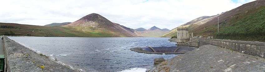
Silent Valley Reservoir is a reservoir located in the Mourne Mountains near Kilkeel, County Down in Northern Ireland. It supplies most of the water for County Down, surrounding counties and most of Belfast. The reservoir was built between 1923 and 1933 by a workforce of over one thousand men, nine of whom died during construction. The catchment area is 9,000-acres (3,600 ha / 36 sq. km).
Ben Crom Reservoir is a reservoir located upstream of Silent Valley near Kilkeel, County Down, Northern Ireland. Along with Silent Valley Reservoir, which is situated further down the Kilkeel River valley, it supplies water for County Down, surrounding counties and most of Belfast. It was constructed between 1953 and 1957.
Spelga Reservoir is a reservoir in the townland of Spelga (Irish: Speilgeach) located close to Hilltown in the North West of the Mourne Mountains . It was formed by construction of Spelga Dam and sits at over 1,200 ft (370 m) above sea level. The dam was constructed between 1953 and 1957. It has a volume of 2,700,000 cubic metres and a catchment area of 1,340-acres (542 ha / 5.423 sq. km).
Fofanny Dam Reservoir is located approximately 2km north-east of Spelga Dam and is a much smaller site.
Flora and fauna
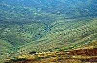
Aside from grasses, the most common plants found in the Mournes are heathers and gorse. Of the former, three species are found: cross-leaved heath, bell heather, and common heather. Of the latter, two species are found: common gorse and western gorse. Other plants which grow in the area are: common cottongrass, roseroot, harebell, marsh St John's-wort, wild thyme, wood sorrel and heath spotted orchid.
Sheep graze high into the mountains, and the range is also home to birds, including the raven, peregrine falcon, wren, buzzard, meadow pipit, grey wagtail, stonechat and snipe. The golden eagle, a former inhabitant, has not been seen in the Mournes since 1836.
Tourism
Information and statistics on tourism to the Mournes was gathered by TourismNI in 2014.[28] On a survey of leisure visitors, 79% were found to come from Northern Ireland itself, 15% were from the remaining areas of the British Isles and Republic of Ireland, leaving 5-6% accounting for international visitors.[29] Of all visitors, two thirds usually visit the Mournes on a single day trip rather than choosing an overnight trip and party sizes have averaged between 3 - 4 people.[30]
The Mourne area and local town of Newcastle offer a range of activities for visitors. These include hiking, forest and beach walks, cycling and rock climbing, with nearly three quarters of visitors choosing the Mournes to go walking and hiking.[31]
Possible national park status
It has been proposed that the Mourne Mountains be made Northern Ireland's first national park.[32][33] The plan has been subject to controversy because of the area's status as private property, with over 1,000 farmers based in the proposed park,[33] and also because of fears over the impact on local communities, bureaucracy and house prices.[34]
Popular culture
The mountains are immortalised in a song written by Percy French in 1896, "The Mountains of Mourne". The song has been recorded by many artists, including Don McLean, and was quoted in Irish group Thin Lizzy's 1979 song 'Roisin Dubh (Black Rose): A Rock Legend.' Frank Baker’s famous Ulster-based comic novel Miss Hargreaves refers to it: “I’m not going to tell you much about the holiday except to say it was a grand month and we enjoyed every bit of it even though it rained much of the time. We went miles in the car, swam in the river, messed about in an old tub of a boat belonging to a farmer; and we spent a good many evenings in the hotel at Dungannon, drinking Irish whiskey and flirting with a cheeky girl Henry rather fell for. We climbed the Mourne Mountains and sang the right song on the top, though we couldn’t remember the words.”
The Mourne Mountains also influenced C.S. Lewis to write The Lion, the Witch and the Wardrobe.[35]
"The Mountains of Mourne" are also mentioned in John Lennon's song "The Luck of the Irish" on the album Some Time in New York City.[36]
The scenery of the Mourne Mountains have also provided the backdrop for a number of productions, most famously in HBO's Game of Thrones.[37]
Recreation
"Discover Northern Ireland", a website operated by Tourism NI, aids to promote the Mourne Mountains as a popular destination for hiking and taking in views of the surrounding landscape, including local forests and the coastline.[38]
There are many granite cliffs, in the form of outcrops and tors, scattered throughout the range, making the Mournes one of Northern Ireland's major rock-climbing areas since the first recorded ascents in the 1930s. The rock forms are generally quite rounded, thus often depending on cams for protection, but with good friction. The 1998 guidebook lists 26 separate crags, with a total of about 900 routes of all grades.[39][40]
Railway access
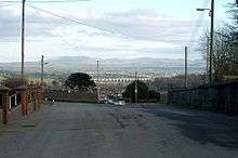
The Northern Ireland Railways service and the Enterprise link into Newry railway station.
Helicopter crash
On 23 October 2010 an AgustaWestland AW109 (tail number: N2NR) was operating a VFR flight from Enniskillen Airport to Caernarfon Airport, Wales. While en route the helicopter crashed into the western side of Shanlieve, killing all three passengers and crew on board. The cause of the accident was determined to be pilot error in heavy fog.[41]
See also
- List of mountains in Ireland
Notes
- MountainViews was created in 2002 by Simon Stewart as a non–profit online database for climbers in Ireland to document and catalogue their Irish climbs.[20] Its main data feed is taken from the Ordnance Survey Ireland ("OSI"). However, it also integrates other established Irish mountain databases such as the Paul Tempan Loganim Irish Placenames Database.[21] Collins Press published its Online Datase in 2013 in the book: A Guide to Ireland's Mountain Summits: The Vandeleur-Lynams & the Arderins.[22] MountainViews is also partnered with the important Database of British and Irish Hills ("DoBIH"), which is the main live database for the categorisation of mountains and hills in the British Isles.
- In all cases this is the "Name Origin and Meaning" column from Paul Tempan's Irish Hill and Mountain Names (2010).[19]
- 'Elevation' is the vertical height of the summit above average sea level.[23]
- 'Topographic prominence' is the height of the summit above the lowest point on the terrain surrounding it.[23]
References
- Pitfield, Mankelow, Cooper, Cameron, Lusty, Shaw, Linley (2012). County Down and Belfast: mineral resource map of Northern Ireland (PDF) (Map). Retrieved 14 October 2019.CS1 maint: multiple names: authors list (link)
- "Ireland's Range High Points". High Point Ireland. 2015.
- "Mourne Area of Outstanding Natural Beauty". NAAONB. 2019. Retrieved 14 October 2019.
- Mourne National Park Working Party (September 2007). Mourne National Park Working Party Report to Minister (Report). Retrieved 14 October 2019.
- "The Mournes". National Trust. 2019. Retrieved 14 October 2019.
- Joyce, Patrick (1869). The origin and history of Irish names of places. p. 128.
- "Placenames Database of Ireland". Logainm.ie. 13 December 2010. Retrieved 6 December 2011.
- "The Mountains of Mourne". The Mourne Mountains. 2015. Retrieved 14 October 2019.
- "Slieve definition of slieve by The Free Dictionary". The Free Dictionary. October 2019. Retrieved 15 October 2019.
- OSNI (24 June 2019). Ordnance Survey Map of the Mournes including Slieve Croob (Map). ISBN 1905306423.
- "poll - Irish English Dictionary". Irishionary. 2019. Retrieved 17 October 2019.
- "púca - Irish English Dictionary". Irishionary. 2019. Retrieved 17 October 2019.
- "Mournes Expedition Area Information" (PDF). The Duke of Edinburgh. February 2011. Retrieved 17 October 2019.
- "Mourne Wall Challenge". Outdoor Recreation Northern Ireland. 2019. Retrieved 17 October 2019.
- "Mourne six peak challenge". DiscoverNI. 2019. Retrieved 17 October 2019.
- "Mourne Mountains from the Isle of Man". Andy Stephenson. 2010. Retrieved 23 January 2020.
- "View of Mourne Mountains over Dublin". gettyimages. Retrieved 22 January 2020.
- "Irish Highest 100: The highest 100 Irish mountains with a prominence of +100m". Mountainviews.ie. September 2018.
- Paul Tempan (February 2012). "Irish Hill and Mountain Names" (PDF). MountainViews.ie.
- "MountainViews.ie, a hillwalking resource for Ireland". Mountaineering Ireland (Irish Mountaineering Council). 2014.
- Simon Stewart (2018). "MountainViews Sources and Credits". MountainViews.ie.
- Mountainviews, (September 2013), "A Guide to Ireland's Mountain Summits: The Vandeleur-Lynams & the Arderins", Collins Books, Cork, ISBN 978-1-84889-164-7
- Svetlana Shele (18 August 2017). "On Terminology: Elevation vs. Altitue vs. Prominence". Retrieved 30 October 2019.
- "Mourne Mountain Mythical Measurements (blog post by Kieron Gribbon)". Retrieved 18 August 2019.
- The Mourne Mountains (2010). "The Mourne Wall". Retrieved 22 January 2020.
- Belfast Plumbing Services (1 August 2016). "History of Belfast Water Supply". Retrieved 22 January 2020.
- "The Mourne Wall - NI Water's very own Wonderwall!". NI Water. 31 May 2019. Retrieved 22 January 2020.
- "Destination Mournes" (PDF). TourismNI. 2014. Retrieved 17 October 2019.
- "Destination Mournes" (PDF). TourismNI. 2014. Retrieved 17 October 2019.
- "Destination Mournes" (PDF). TourismNI. 2014. Retrieved 17 October 2019.
- "Destination Mournes" (PDF). TourismNI. 2014. Retrieved 17 October 2019.
- "Minister paves the way for national park in the Mournes". Northern Ireland Planning Service. 25 September 2002. Retrieved 11 October 2009.
- Peterkin, Tom (29 August 2007). "Mourne Mountains national park status row". Daily Telegraph. Retrieved 11 October 2009.
- Cassidy, Martin (23 February 2007). "Community split over national park". BBC News. Retrieved 11 October 2009.
- "Mourne Mountains Page". Discover Northern Ireland. Archived from the original on 19 February 2011. Retrieved 6 December 2011.
- "The Luck of the Irish Lyrics and Guitar Chords". Irish Folk Songs. Retrieved 19 August 2019.
- "Game of Thrones Filming & Production". Retrieved 19 August 2019.
- "Mourne Mountains". Retrieved 19 August 2019.
- "Irish Climbing Online Wiki – Co. Down". Retrieved 7 April 2011.
- Robert Bankhead, ed. (1998), Mournes: MCI Guide, Mountaineering Ireland, ISBN 0-902940-14-7
- "Agusta A109A II, N2NR, 23 October 2010" (PDF). Retrieved 23 October 2010.
- Kirk, David (2002). The Mountains of Mourne: A Celebration of a Place Apart. Belfast: Appletree Press. ISBN 0-86281-846-X.
External links
| Wikimedia Commons has media related to Mourne Mountains. |
| Wikivoyage has a travel guide for Mourne Mountains. |
- About the Mourne Mountains
- The website of the book above under 'References'
- A local family's site with some information about the mountains
- Mournes Climbers
- Photos, maps and commentary of the walk around the Mourne Wall
- BBC article about the Mourne Wall
Mountains and hills of Ulster | ||
|---|---|---|
| Antrim Hills | 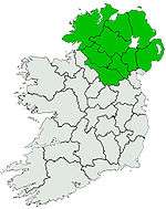 | |
| Antrim Plateau | ||
| Belfast Hills | ||
| Croaghgorms | ||
| Derryveagh | ||
| Inishowen | ||
| Mournes | ||
| Sperrins | ||
| Southwest Donegal | ||
| Others | ||