Mount Airy, North Carolina
Mount Airy /ˈmaʊntəri/[6] is a city in Surry County, North Carolina, United States. As of the 2010 census, the city population was 10,388.[2]
Mount Airy, North Carolina | |
|---|---|
 Downtown Mount Airy | |
| Nickname(s): Mayberry, Granite City | |
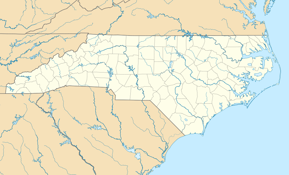 Mount Airy, North Carolina Location within the state of North Carolina | |
| Coordinates: 36°30′N 80°37′W | |
| Country | United States |
| State | North Carolina |
| County | Surry |
| Settled | 1750s |
| Incorporated | 1885 |
| Government | |
| • Mayor | David Rowe |
| Area | |
| • Total | 11.83 sq mi (30.64 km2) |
| • Land | 11.69 sq mi (30.27 km2) |
| • Water | 0.14 sq mi (0.37 km2) |
| Elevation | 1,115 ft (340 m) |
| Population | |
| • Total | 10,388 |
| • Estimate (2019)[3] | 10,208 |
| • Density | 873.52/sq mi (337.27/km2) |
| Time zone | UTC−5 (Eastern (EST)) |
| • Summer (DST) | UTC−4 (EDT) |
| ZIP codes | 27030-27031 |
| Area code(s) | 336 |
| FIPS code | 37-44800[4] |
| GNIS feature ID | 0990306[5] |
| Website | http://www.mountairy.org/ |
History
Mount Airy was settled in the 1750s as a stagecoach stop on the road between Winston-Salem, North Carolina and Galax, Virginia. It was named for a nearby plantation. Mount Airy was incorporated in 1885.[7] The City's official seal was established in 1977, which depicts major industries that are home to Mount Airy including: furniture, textiles, and the granite quarry.[8] In 1994, Mount Airy was named an All American City.[8]
The W. F. Carter House, William Carter House, Edgar Harvey Hennis House, William Alfred Moore House, Mount Airy Historic District, North Carolina Granite Corporation Quarry Complex, Renfro Mill, and Trinity Episcopal Church are listed on the National Register of Historic Places.[9]
Geography
Mount Airy is located at 36°30′N 80°37′W (36.5006, −80.6093),[10] along the Ararat River, about 5 km (3 mi) south of the Virginia state line. The United States Census Bureau says the city has a total area of 8.4 square miles (22 km2), all of it land. The city is located at the foothills of the Blue Ridge Mountains, about 14 miles from the Blue Ridge Parkway.[11]
| Climate data for Mount Airy, North Carolina (1981–2010 normals) | |||||||||||||
|---|---|---|---|---|---|---|---|---|---|---|---|---|---|
| Month | Jan | Feb | Mar | Apr | May | Jun | Jul | Aug | Sep | Oct | Nov | Dec | Year |
| Average high °F (°C) | 46.7 (8.2) |
50.5 (10.3) |
58.9 (14.9) |
68.5 (20.3) |
76.2 (24.6) |
83.7 (28.7) |
86.7 (30.4) |
85.7 (29.8) |
79.5 (26.4) |
70.3 (21.3) |
60.0 (15.6) |
49.1 (9.5) |
68.0 (20.0) |
| Average low °F (°C) | 23.3 (−4.8) |
25.5 (−3.6) |
31.3 (−0.4) |
39.6 (4.2) |
49.3 (9.6) |
58.8 (14.9) |
62.9 (17.2) |
61.7 (16.5) |
54.2 (12.3) |
42.3 (5.7) |
32.7 (0.4) |
25.9 (−3.4) |
42.3 (5.7) |
| Average precipitation inches (mm) | 3.67 (93) |
3.15 (80) |
4.12 (105) |
3.69 (94) |
4.25 (108) |
4.46 (113) |
5.09 (129) |
4.14 (105) |
3.99 (101) |
3.32 (84) |
3.51 (89) |
3.55 (90) |
46.93 (1,192) |
| Average snowfall inches (cm) | 3.6 (9.1) |
3.0 (7.6) |
0.6 (1.5) |
0 (0) |
0 (0) |
0 (0) |
0 (0) |
0 (0) |
0 (0) |
0 (0) |
0 (0) |
1.8 (4.6) |
9.0 (23) |
| Average precipitation days (≥ 0.01 in) | 10.6 | 10.0 | 11.1 | 10.9 | 13.2 | 11.7 | 13.6 | 11.6 | 10.0 | 8.4 | 9.5 | 10.8 | 131.4 |
| Average snowy days (≥ 0.1 in) | 1.4 | 1.5 | 0.3 | 0 | 0 | 0 | 0 | 0 | 0 | 0 | 0 | 0.9 | 4.1 |
| Source: NOAA[12] | |||||||||||||
Demographics
| Historical population | |||
|---|---|---|---|
| Census | Pop. | %± | |
| 1880 | 519 | — | |
| 1890 | 1,768 | 240.7% | |
| 1900 | 2,680 | 51.6% | |
| 1910 | 3,844 | 43.4% | |
| 1920 | 4,752 | 23.6% | |
| 1930 | 6,045 | 27.2% | |
| 1940 | 6,286 | 4.0% | |
| 1950 | 7,192 | 14.4% | |
| 1960 | 7,055 | −1.9% | |
| 1970 | 7,325 | 3.8% | |
| 1980 | 6,862 | −6.3% | |
| 1990 | 7,156 | 4.3% | |
| 2000 | 8,484 | 18.6% | |
| 2010 | 10,388 | 22.4% | |
| Est. 2019 | 10,208 | [3] | −1.7% |
| U.S. Decennial Census[13] | |||
As of the census of 2010, there were 10,388 people in 4,934 households. The people per square mile was 891.4. There were 5,296 housing units. The Population percent change from 2000 to 2010 was 22.4% up. The racial makeup of the city was 84.1% White descent, 8.2% African American, 0.3% American Indian and Alaska Native, 1.4% Asian, 0.1% Native Hawaiian and Other Pacific Islander, 2.2% Persons reporting two or more races, 6.7% Hispanic or Latino. Persons per household was 2.10. Average household income was $35,428. Persons below poverty level was 21.1%. High school graduates were 76.9% and bachelor's degree or higher was 25.9%.
As of the census[4] of 2000, there were 8,484 people, 3,667 households, and 2,130 families residing in the city. The population density was 1,010.8 people per square mile (390.4/km2). There were 4,129 housing units at an average density of 491.9 per square mile (190.0/km2). The racial makeup of the city was 85.34% White descent, 7.99% African American, 0.35% Native American, 2.55% Asian American, 0.05% Pacific Islander, 2.49% from other races, and 1.24% from two or more races. Hispanic or Latino of any race were 5.87% of the population.

There were 3,667 households, out of which 24.3% had children under the age of 18 living with them, 40.6% were married couples living together, 14.0% had a female householder with no husband present, and 41.9% were non-families. 38.5% of all households were made up of individuals, and 19.6% had someone living alone who was 65 years of age or older. The average household size was 2.16 and the average family size was 2.87.
In the city, the population was spread out, with 21.6% under the age of 18, 6.5% from 18 to 24, 25.1% from 25 to 44, 21.3% from 45 to 64, and 25.6% who were 65 years of age or older. The median age was 43 years. For every 100 females, there were 84.5 males. For every 100 females age 18 and over, there were 78.4 males.
The median income for a household in the city was $26,910, and the median income for a family was $33,412. Males had a median income of $27,299 versus $24,830 for females. The per capita income for the city was $17,237. About 17.4% of families and 19.9% of the population were below the poverty line, including 24.7% of those under age 18 and 20.7% of those age 65 or over.
Mayberry
Actor Andy Griffith was born in Mount Airy, and the town is believed[14] to have been the basis for Mayberry, the setting of the TV shows The Andy Griffith Show and Mayberry RFD.[15] The community holds an annual "Mayberry Days" celebration during the last weekend of September; 30,000 attended in 2009, and 50,000 attended for the show's 50th anniversary in 2010. The University of North Carolina at Greensboro estimates the town receives $5 million each year as a result. Surviving members of the cast, along with family members of other cast members, often visit. The 2012 event was slated to have Karen Knotts (Don's daughter) and George Lindsey Jr. (eponymous son of the actor who portrayed Goober).
Three Ford Galaxie police cars, painted to resemble those used on the show, give rides to tourists.[16] A barber shop has been named "Floyd's."
The Andy Griffith Museum, founded in 2009 by Emmett Forrest, attracts 200 visitors a day.[17][18] The 2,500-square-feet museum, located half a mile from Griffith's childhood home, houses the world's largest collection of Andy Griffith memorabilia.[19]
The Autumn Leaves Festival
Held the second weekend in October, the Autumn Leaves Festival attracts over 200,000 people to the city during the festival weekend.[20] Vendors sell food and other items, and there is a stage for musicians.[20]
Bluegrass and old-time music
The home of old-time music legend Tommy Jarrell, bluegrass gospel legends The Easter Brothers, country singer Donna Fargo, Mount Airy has a long history with regional music. Mount Airy's WPAQ 740 AM radio is one of the few Bluegrass and Old-Time music stations still operating and has been airing the live radio show Merry-Go-Round from the Downtown Cinema Theatre since 1948. Weekly bluegrass jam sessions at The Andy Griffith Playhouse and the annual Mount Airy Fiddlers Convention also serve to attract old-time musicians from across the region and the world. The Fiddlers Convention first began in 1972, and is held the first weekend in June at Veterans Memorial Park.[21] The Blue Ridge Music Center with its amphitheater and music museum of old-time music is just a few miles away on the Blue Ridge Parkway at Milepost 213, near Galax, Virginia. This area is home to the Round Peak style of old-time music, which started in the Round Peak community, just west of Mount Airy.[22]
Chang and Eng Bunker
Mount Airy was the residence of Chang and Eng Bunker (1811–1874), conjoined twins joined by a band of cartilage at the chest (xiphopagus).[15] They are buried at White Plains Baptist Church about 2 miles from Mt Airy Main street. Many of their descendants still live in the Mount Airy area.
Education
The Mt. Airy Public Library serves the community. The library won the American Institute of Architects Design Award.[23]
Mount Airy has a city-funded school district consisting of four schools.
Mount Airy City Schools
- Mount Airy High School
- Mount Airy Middle School
- Jones Intermediate School
- Tharrington Primary School
Surry County Schools
There are also other schools in Mount Airy that are controlled by the Surry County Schools district.
- North Surry High School
- Gentry Middle School
- Meadowview Magnet Middle School
- Cedar Ridge Elementary School
- Flat Rock Elementary School
- Franklin Elementary School
- White Plains Elementary School
Charter schools
Mount Airy has one k-12 public-funded charter school, Millennium Charter Academy.
Private schools
- White Plains Christian School
Notable people
- Frank Beamer (born 1946), head football coach Virginia Tech, born in Mount Airy, raised in Fancy Gap, Virginia
- Ron Blackburn (1935–1998), Major League Baseball player
- Chang and Eng Bunker (1811–1874), famous "Siamese Twins" conjoined twins of showman P.T. Barnum who settled in Mount Airy after they retired from show business
- Ben Callahan (1957–2007), Major League Baseball player
- Chubby Dean (1916–1970), Major League Baseball player
- Donna Fargo (born 1945), country music singer and songwriter, best known for the song "The Happiest Girl in the Whole USA"
- Benton Flippen (1920–2011), old-time fiddler, banjo player, and guitarist
- Emmett Forrest (1927–2013), founder of the Andy Griffith Museum[18]
- Maddie Gardner, (born 1993), local news reporter and internationally recognized cheerleader
- Andy Griffith (1926–2012), American actor
- Bill Hayes, television producer[24]
- Jerry Hemmings (born 1948), basketball coach
- Tommy Jarrell (1901–1985), old-time fiddler, banjo player, and singer
- Luke Lambert, NASCAR crew chief[25]
- Betty Lynn (born 1926), actress
- Mark Daniel Merritt (born 1961), American music composer
- Alex Sink, former chief financial officer of Florida, Democratic nominee for governor of Florida in 2010
- Anna Wood (born 1985), actress
References
- "2019 U.S. Gazetteer Files". United States Census Bureau. Retrieved July 27, 2020.
- "2010 City Population and Housing Occupancy Status". U.S. Census Bureau. Retrieved May 12, 2011.
- "Population and Housing Unit Estimates". United States Census Bureau. May 24, 2020. Retrieved May 27, 2020.
- "U.S. Census website". United States Census Bureau. Retrieved 2008-01-31.
- "US Board on Geographic Names". United States Geological Survey. 2007-10-25. Retrieved 2008-01-31.
- Rick Aschmann (2 May 2018). "North American English Dialects, Based on Pronunciation Patterns". Aschmann.net. Retrieved 25 November 2019.
- Dickson, Scott (2005). In Search of Mayberry. Boone, North Carolina: Parkway Publishers, Inc. p. 75. ISBN 1-887905-98-7.
- "History of Mount Airy | Mount Airy, NC - Official Website". www.mountairy.org. Retrieved 2018-02-05.
- "National Register Information System". National Register of Historic Places. National Park Service. July 9, 2010.
- "US Gazetteer files: 2010, 2000, and 1990". United States Census Bureau. 2011-02-12. Retrieved 2011-04-23.
- "Blue Ridge Parkway « Visit Mayberry". www.visitmayberry.com. Retrieved 2018-02-05.
- "NowData - NOAA Online Weather Data". National Oceanic and Atmospheric Administration. Retrieved 2013-07-03.
- "Census of Population and Housing". Census.gov. Retrieved June 4, 2015.
- "The Andy Griffith Show built North Carolina on the backlot". avclub.com. Retrieved July 10, 2014.
- "Famous Citizens/History". mountairydowntown.org. Archived from the original on April 30, 2013. Retrieved August 6, 2012.
- "Squad Car Tours". VisitNC.com. Archived from the original on 2018-02-14. Retrieved 2018-02-13.
- Washburn, Mark (2010-08-28). "Goober's suit enshrined in town Mayberry built". The Charlotte Observer. Archived from the original on 2013-01-05. Retrieved 2010-08-28.
- Stange, Keith (2013-01-12). "Emmett Forrest, long-time Andy Griffith friend, has died". The Mount Airy News. Archived from the original on 2013-01-31. Retrieved 2013-02-10.
- "Well, I'll be: Andy Griffith Museum opens". The Business Journal. 2010-01-13. Retrieved 2013-02-10.
- "Mayberry North Carolina | Bluegrass Music Festivals | NC Events". Autumn Leaves Festival. Retrieved 2018-02-05.
- www.paleosun.com, PaleoSun, Inc. Web Development. "Mount Airy Bluegrass and Old-Time Fiddlers' Convention | Blue Ridge Music Trails". Blue Ridge Music Trails. Retrieved 2018-02-13.
- "Archived copy". Archived from the original on 2014-02-21. Retrieved 2014-01-29.CS1 maint: archived copy as title (link)
- "Mt. Airy Public Library." Mazria Inc. Retrieved on August 28, 2012.
- "Bill Hayes".
- "Luke Lambert makes dream come true with NASCAR", Mount Airy News, 22 October 2012, Accessed: 25 January 2016.
- Joyce, Tom. (Jul 21, 2019). Siamese Twins unite sister cities. The Mount Airy News. Retrieved Jul 22, 2020.
Further reading
- Bailey, Sarah Pulliam (January 5, 2017). "How nostalgia for white Christian America drove so many Americans to vote for Trump". Washington Post. Retrieved January 5, 2017. Social attitudes in Mount Airy
External links
| Wikimedia Commons has media related to Mount Airy, North Carolina. |
- City of Mount Airy
- VisitMayberry
- Downtown Mount Airy
- Mayberry Days
- Mayberry Takeout
- Mt Airy NC Chamber
- Andy Griffith Museum
Municipalities and communities of Surry County, North Carolina, United States | ||
|---|---|---|
| City |  Map of North Carolina highlighting Surry County | |
| Towns | ||
| Townships | ||
| CDPs | ||
| Unincorporated communities |
| |
| Footnotes | ‡This populated place also has portions in an adjacent county or counties | |
| Authority control |
|
|---|