Maupiti
Maupiti is a small coral atoll with a volcanic island in its midst. It has a population of 1,200 people living on 11 square kilometres (4.2 square miles)
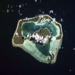 NASA aerial picture of Maupiti | |
 | |
| Geography | |
|---|---|
| Location | Pacific Ocean |
| Coordinates | 16°26′24.3″S 152°16′27.3″W |
| Archipelago | Society Islands |
| Major islands | Maupiti |
| Area | 11 km2 (4.2 sq mi) |
| Highest elevation | 380 m (1,250 ft) |
| Administration | |
| Overseas collectivity | French Polynesia |
| Demographics | |
| Population | 1,200 |
| Pop. density | 109/km2 (282/sq mi) |
| Additional information | |
 | |
Geography
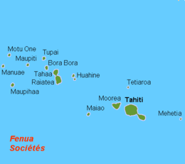
Maupiti is located in the western Leeward Islands in French Polynesia. It is the westernmost volcanic high island in the archipelago, 40 kilometres (25 miles) west of Bora Bora. The central island of Maupiti has a high peak of 380 metres (1,250 feet) and a surface area of 11 square kilometres (4.2 square miles). The lagoon has large and flat coral islands in its northern reef half and two motus on both sides of the pass at its southern end.
Population
At the August 2007 census, the island population was about 1,200 people.
History
There are ancient Polynesian archaeological artifacts dating from at least AD 850 in Maupiti. The first European to arrive on the island was the Dutchman Jakob Roggeveen in 1722. Historically, the island has had strong cultural links with Bora Bora.
Administration
Maupiti is administratively part of the commune (municipality) of Maupiti, itself in the administrative subdivision of the Leeward Islands. The main settlement is Vaiea.
References
- "MAUPITI - THE ECONOMY AT HALF FALLS DOWN HEIVA". la depeche.