Huahine
Huahine is an island located among the Society Islands, in French Polynesia, an overseas territory of France in the Pacific Ocean. It is part of the Leeward Islands group (Îles sous le Vent). At the 2017 census it had a population of 6,075.[1]
Huahine | |
|---|---|
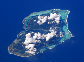 NASA picture of Huahine viewed from the north | |
 Flag | |
 | |
Location of Huahine 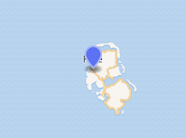
| |
| Coordinates: 16°44′S 151°00′W | |
| Country | France |
| Overseas collectivity | French Polynesia |
| Subdivision | Leeward Islands |
| Government | |
| • Mayor (2014 - 2020) | Marcelin Lisan |
| Area 1 | 75 km2 (29 sq mi) |
| Population (2017) | 6,075 |
| • Density | 81/km2 (210/sq mi) |
| Time zone | UTC−10:00 |
| INSEE/Postal code | 98724 /98731 |
| Elevation | 0–669 m (0–2,195 ft) |
| 1 French Land Register data, which excludes lakes, ponds, glaciers > 1 km2 (0.386 sq mi or 247 acres) and river estuaries. | |
Geography
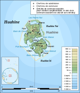
Huahine measures 16 km (10 mi) in length, with a maximum width of 13 km (8 mi). It is made up of two main islands surrounded by a fringing coral reef with several islets, or motu. Huahine Nui (Big Huahine) lies to the north and Huahine Iti (Little Huahine) to the south. The total land area is 75 km2.[2] The two islands are separated by a few hundred metres of water and joined by a sandspit at low tide. A small bridge was built to connect Huahine Nui and Huahine Iti. Its highest point is Turi, at 669 m elevation.
In the northwest of Huahine Nui lies a 375 hectares (926.65 acres) brackish lake known as Lac Fauna Nui (Lac Maeva). This lake is all that remains of the ancient atoll lagoon. Air transportation is available via Huahine airport, located on the northern shore of Huahine Nui.
History
Captain James Cook arrived in Fare Harbour on 16 July 1769, with Tupaia navigating HMS Endeavour. They met with leading chief Ori (Mato). Cook returned on 3 September 1773 and met with Ori's son Teri'itaria, the new ari'i rahi of the island.[3]
Missionary Auna served as a deacon on Huahine prior to his work in Hawaii.[4]
Administration
Administratively Huahine is a commune (municipality) part of the administrative subdivision of the Leeward Islands.[5] Huahine consists of the following associated communes:[6]
- Faie
- Fare
- Fitii
- Haapu
- Maeva
- Maroe
- Parea
- Tefarerii
The administrative centre of the commune is the settlement of Fare,[6] on Huahine Nui.
Transportation
The island has scheduled passenger airline flights operated by Air Tahiti with ATR turboprop aircraft via the Huahine - Fare Airport.
Tourist attraction
One of the famous attractions on Huahine is a bridge that crosses over a stream with 0.9 m - 1.8 m long freshwater eels. These eels are deemed sacred by the locals, by local mythology. While viewing these slithering creatures, tourists can buy a can of mackerel and feed the eels. The Fa'ahia archaeological site in the north of the island has revealed subfossil remains of several species of extinct birds exterminated by the earliest Polynesian colonists of the island.
References
- Répartition de la population en Polynésie française en 2017, Institut de la statistique de la Polynésie française
- Communes of French Polynesia, statoids.com
- Salmond, Anne (2010). Aphrodite's Island. Berkeley: University of California Press. pp. 205–209, 281, 314–318. ISBN 9780520261143.
- Garrett, John (1999). "Auna". In Gerald H. Anderson (ed.). Biographical Dictionary of Christian Missions. Wm. B. Eerdmans Publishing. ISBN 978-0-8028-4680-8.
- Décret n° 2005-1611 du 20 décembre 2005 pris pour l'application du statut d'autonomie de la Polynésie française, Légifrance
- Décret n°72-407 du 17 mai 1972 portant création de communes dans le territoire de la Polynésie française, Légifrance
External links
- Tahiti Tourism Board website
- Tourism portal on Huahine
- Free travel guide - Bilingual french english - 2016-2017