Marcy, New York
Marcy is a town in Oneida County, New York, United States. The population was 8,982 at the 2010 census. The town was named after Governor William L. Marcy.[3] It lies between the cities of Rome and Utica. The Erie Canal passes through the southern part of the town.
Marcy, New York | |
|---|---|
Town | |
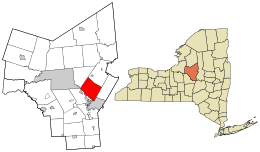 Location in Oneida County and the state of New York. | |
| Coordinates: 43°10′N 75°17′W | |
| Country | United States |
| State | New York |
| County | Oneida |
| Government | |
| • Type | Town Council |
| • Town Supervisor | Brian N. Scala (R) |
| • Town Council | Members' List
|
| Area | |
| • Total | 33.32 sq mi (86.29 km2) |
| • Land | 32.89 sq mi (85.18 km2) |
| • Water | 0.43 sq mi (1.11 km2) |
| Elevation | 827 ft (252 m) |
| Population (2010) | |
| • Total | 8,982 |
| • Estimate (2016)[2] | 9,410 |
| • Density | 286.11/sq mi (110.47/km2) |
| Time zone | UTC-5 (Eastern (EST)) |
| • Summer (DST) | UTC-4 (EDT) |
| ZIP code | 13403 |
| Area code(s) | 315 |
| FIPS code | 36-45535 |
| GNIS feature ID | 0979197 |
| Website | Town of Marcy, NY |
The town is home to the SUNY Polytechnic Institute, a four-year public research university in the southeastern part of town.
History
The first settlers arrived around 1773. During the American Revolution, the settlers, having been warned by a friendly Oneida Indian about an enemy raid, abandoned their farms until after the war. The town was resettled in 1792.
The Town of Marcy was formed in 1832 from part of the Town of Deerfield, located to the east.
In 1920, the population of Marcy was 1,919.
The Neck Canal of 1730 was listed on the National Register of Historic Places in 1995.[4]
Geography
According to the United States Census Bureau, the town has a total area of 33.4 square miles (87 km2), of which, 33.0 square miles (85 km2) of it is land and 0.4 square miles (1.0 km2) of it (1.35%) is water.
The Mohawk River defines the south town line.
The New York State Thruway (Interstate 90) passes through the southeast corner of the town.
The Erie Canal (also known as the Barge Canal) passes through the south end of the town, running along River Road, with Lock 20 Canal Park just east of the Route 291 bridge lying on the canal.
SUNY Polytechnic Institute is located on 700 acres northwest of the intersection of the North-South Arterial (NY 8 and NY 12) and NY 49.
Demographics
| Historical population | |||
|---|---|---|---|
| Census | Pop. | %± | |
| 1840 | 1,799 | — | |
| 1850 | 1,857 | 3.2% | |
| 1860 | 1,687 | −9.2% | |
| 1870 | 1,451 | −14.0% | |
| 1880 | 1,413 | −2.6% | |
| 1890 | 1,213 | −14.2% | |
| 1900 | 1,398 | 15.3% | |
| 1910 | 1,301 | −6.9% | |
| 1920 | 1,191 | −8.5% | |
| 1930 | 2,604 | 118.6% | |
| 1940 | 4,528 | 73.9% | |
| 1950 | 5,210 | 15.1% | |
| 1960 | 7,024 | 34.8% | |
| 1970 | 7,877 | 12.1% | |
| 1980 | 6,222 | −21.0% | |
| 1990 | 8,685 | 39.6% | |
| 2000 | 9,481 | 9.2% | |
| 2010 | 8,982 | −5.3% | |
| Est. 2016 | 9,410 | [2] | 4.8% |
| U.S. Decennial Census[5] | |||
As of the census[6] of 2000, there were 9,469 people, 2,003 households, and 1,526 families residing in the town. The population density was 287.2 people per square mile (110.9/km2). There were 2,073 housing units at an average density of 62.9 per square mile (24.3/km2). The racial makeup of the town was 68.42% White, 22.20% African American, 0.27% Native American, 0.60% Asian, 0.04% Pacific Islander, 6.55% from other races, and 1.91% from two or more races. Hispanic or Latino of any race were 14.02% of the population.
There were 2,003 households, out of which 33.0% had children under the age of 18 living with them, 65.5% were married couples living together, 6.9% had a female householder with no husband present, and 23.8% were non-families. 19.6% of all households were made up of individuals, and 8.0% had someone living alone who was 65 years of age or older. The average household size was 2.60 and the average family size was 2.99.
In the town, the population was spread out, with 13.2% under the age of 18, 13.4% from 18 to 24, 44.7% from 25 to 44, 20.3% from 45 to 64, and 8.5% who were 65 years of age or older. The median age was 36 years. For every 100 females, there were 242.8 males. For every 100 females age 18 and over, there were 276.2 males.
The median income for a household in the town was $47,180, and the median income for a family was $54,231. Males had a median income of $30,943 versus $25,044 for females. The per capita income for the town was $16,182. About 3.7% of families and 5.4% of the population were below the poverty line, including 9.2% of those under age 18 and 2.3% of those age 65 or over.
Communities and locations in Marcy
- Careys Corners – A hamlet in the south part of the town by the Erie Canal. This no longer exists. It is now the offramp for NY 291 from the Utica-Rome Expressway.
- Marcy – The hamlet of Marcy is in the south part of the town.
- Marcy Correctional Facility – A state prison located near Marcy.
- Marcy Hill – An elevation located north of Utica.
- Maynard – A hamlet in the southeast part of the town.
- Mid-State Correctional Facility – A prison near Marcy.
- Stittville – A hamlet in the northwest corner of the town.
- Frederick R. Clark Energy Center of the New York Power Authority
Notable people
- Lynette "Squeaky" Fromme, former member of the Manson Family and attempted assassin of Gerald Ford, lives in Marcy.[7]
- Rouse Simmons, Wisconsin legislator and businessman, was born in Marcy.[8]
References
- "2016 U.S. Gazetteer Files". United States Census Bureau. Retrieved Jul 5, 2017.
- "Population and Housing Unit Estimates". Retrieved June 9, 2017.
- Gannett, Henry (1905). The Origin of Certain Place Names in the United States. U.S. Government Printing Office. p. 199.
- "National Register Information System". National Register of Historic Places. National Park Service. March 13, 2009.
- "Census of Population and Housing". Census.gov. Retrieved June 4, 2015.
- "U.S. Census website". United States Census Bureau. Retrieved 2008-01-31.
- Fusco, Jennifer; Rocco LaDuca (2009-09-14). "Would-be Ford assassin 'Squeaky' Fromme moving to Marcy". Observer Dispatch. Archived from the original on 2012-09-19. Retrieved 2009-09-28.
- 'Wisconsin Blue Book 1875,' Biographical Sketch of Rouse Simmons, pg. 326
External links
Municipalities and communities of Oneida County, New York, United States | ||
|---|---|---|
| Cities | 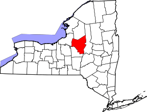 | |
| Towns | ||
| Villages | ||
| CDPs | ||
| Hamlets | ||
| Authority control |
|
|---|