Malpelo Island
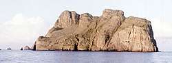
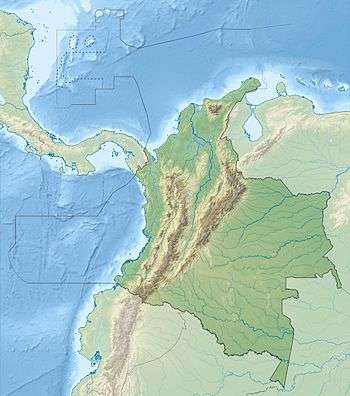
Malpelo is a small island in the eastern Pacific Ocean, located about 500 km (310 mi) west of the Colombian mainland with a military post manned by the Colombian Armed Forces. It consists of a sheer and barren rock with three high peaks, the highest being Cerro de la Mona with a height of 300 m (980 ft). The island is about a mile in length from northeast to southwest, and 700 yards in width.
| Native name: Isla de Malpelo | |
|---|---|
 Profile of Malpelo Island | |
 Malpelo Island  Malpelo Island | |
| Geography | |
| Location | Pacific Ocean |
| Coordinates | 04°00′10″N 81°36′32″W |
| Area | 1.2 km2 (0.46 sq mi) |
| Length | 1.643 km (1.0209 mi) |
| Width | 0.727 km (0.4517 mi) |
| Highest elevation | 360 m (1,180 ft) |
| Highest point | Cerro La Mona |
| Administration | |
| Department | Valle del Cauca |
| Municipality | Buenaventura |
| Demographics | |
| Population | Uninhabited |
| Official name | Malpelo Fauna and Flora Sanctuary |
| Type | Natural |
| Criteria | vii, ix |
| Designated | 2006 |
| Reference no. | 1216 |
| State Party | Colombia |
| Region | Latin America and the Caribbean |
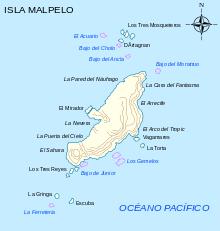
It is the only island that rises above the surface from the Malpelo Ridge, which is a solitary volcanic submarine ridge that extends in a northeast-southwest direction with a length of 300 km (190 mi) and a width of 100 km (62 mi). This island is surrounded by a number of offshore rocks. Off the northeast corner are the Tres Mosqueteros. Off the southwest corner are Salomon, Saul, La Gringa, and Escuba. All the rocks are surrounded by deep water, and most of the face of the main island is very steep. Soundings between 1,000 and 5,000 fathoms are obtainable within a few miles of the shore and the currents are strong and changeable. As an oceanic island, it has never been connected with any other islands or the mainland.[1][2]
Malpelo Island is composed of Miocene pillow lavas, volcanic breccias, and basaltic dikes that have been dated as being 16 to 17 million years old. This island and the underlying and underwater Malpelo Ridge were created along with the Carnegie Ridge in the Late Miocene by a very complex interaction between the Cocos-Nazca Spreading Centre and the Galápagos hotspot.[1][2][3]
At first glance, the island seems to be barren rock, devoid of all vegetation, but deposits of bird guano have helped colonies of algae, lichens, mosses, and some shrubs and ferns establish, all of which glean nutrients from the guano. The Malpelo Nature Reserve, a plant and wildlife sanctuary, is defined as a circular area of radius 9.656 km (6.000 mi) centered at 03°58′30″N 81°34′48″W. On July 12, 2006, Malpelo was declared by UNESCO as a natural World Heritage Site. A Colombian foundation[4] is trying to preserve the biodiversity of the site.
Malpelo is home of a unique shark population; swarms of 500 hammerhead sharks and hundreds of silky sharks are frequently seen by diving expeditions, making it a very popular shark-diving location. It is one of the few places where the smalltooth sand tiger has been seen alive; it is frequently spotted at the dive site "El bajo del Monstruo".[5] Acanthemblemaria stephensi, the Malpelo barnacle blenny, is a species of chaenopsid blenny found in coral reefs around Malpelo.
Chronology
- 1530 - Malpelo is said to have been recorded in a map of this date.
- 1542 - Cristóbal Vaca de Castro visited.
- 1550 - Malpelo was recorded in Pierre Desceliers' map.
- 1704 - Wreck of the English vessel Cinque Ports
- 1790 - Spanish landing on Malpelo was mentioned to Alessandro Malaspina.
- 1793 - James Colnett visited.
- 1837 - A note in The Nautical Magazine recorded a visit.
- 1995 - Malpelo was designated as a flora and fauna sanctuary.[6]
Gallery
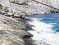 Shore and cliffs
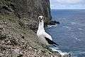 Nazca booby Sula granti
References
- Anonymous (2010) Pacific Coast: Malpelo Island, Coasts of Colombia. Coastal and Marine Geology Program, United States Geological Survey, Santa Cruz, California.
- Marcaillou, B. P. Charvis, and J.-Y. Collot (2006) Structure of the Malpelo Ridge (Colombia) from seismic and gravity modeling. Marine Geophysical Research. 27:289–300.
- Hoernle K., P. Bogaard, R. Werner, F. Hauff, B. Lissinna, G.E. Alvarado and D. Garbe-Schnberg (2002) Missing history (16–71 Ma) of the Galápagos hotspot: implications for the tectonic and biological evolution of the Americas. Geology. 30(9):795–798.
- Fundación Malpelo y Otros Ecosistemas Marinos
- Schneider, P. (nd) Malpelo Island the "Mount Everest" of shark and large pelagic diving. Advanced Diver Magazine Digital. Bradenton, Florida.
- Malpelo Fauna and Flora Sanctuary in Colombia Protected Planet
![]()
Further reading
- Verga, Giovanni (1936). Malpelo (in Spanish). México: Departamento de Biblioteca de la Secretaría de Educación Pública.
- Prahl, Henry von (1990). Malpelo la roca viviente (in Spanish) (1. ed.). Bogotá, Colombia: Fondo para la Protección del Medio Ambiente.
- Parques Nacionales Naturales de Colombia. Fundación Malpelo y Otros Ecosistemas Marinos. Plan de Manejo del Santuario de Flora y Fauna de Malpelo (PDF) (in Spanish). Bogotá, Colombia: Fondo para la Protección del Medio Ambiente. Retrieved 2014-01-05.
External links
- Fundación Malpelo
- UNESCO World Heritage profile
- (in German) Report on diving at Malpelo, with photos of sharks
- (in Spanish) Isla de Malpelo
.svg.png)
Recreational dive sites in Colombia | ||
|---|---|---|
| Caribbean coast | | |
| Caribbean insular |
| |
| Pacific | ||
| Andean | ||
Treasures of Colombia | |||||||||||||||||||||||||||||
|---|---|---|---|---|---|---|---|---|---|---|---|---|---|---|---|---|---|---|---|---|---|---|---|---|---|---|---|---|---|
| |||||||||||||||||||||||||||||
| |||||||||||||||||||||||||||||
| |||||||||||||||||||||||||||||
| |||||||||||||||||||||||||||||
Source: Wills, Fernando et al. 2001. Nuestro patrimonio - 100 tesoros de Colombia - Our heritage - 100 treasures of Colombia, 1–311. El Tiempo.ISBN 958-8089-16-6 | |||||||||||||||||||||||||||||
| ||