Mallard, California
Mallard (also, Mallard Siding) is a former settlement in Alameda County, California. It was located on the Southern Pacific Railroad 1 mile (1.6 km) east-southeast of the present downtown Fremont,[2] at an elevation of 52 feet (16 m).
Mallard | |
|---|---|
Former settlement | |
 Mallard Location in California | |
| Coordinates: 37°32′47″N 121°57′25″W | |
| Country | United States |
| State | California |
| County | Alameda County |
| Elevation | 52 ft (16 m) |
Mallard is also the name of a former ferry slip of the Sacramento Northern Railway (SN), located along the Sacramento-San Joaquin Delta shoreline of Contra Costa County, California, at West Pittsburg (now considered part of unincorporated Bay Point). The ferry slip took its name from Mallard Slough, a naturally forming inlet off Suisun Bay, near where the railroad tracks terminated at the slip. Mallard Slough is now the site of a pump station for the Contra Costa Water District. At the ferry slip, passenger rail cars of the electric interurban line run by the SN were carried across the water to Chipps Island, proceeding on rails there into Solano County, toward Sacramento.
References
- U.S. Geological Survey Geographic Names Information System: Mallard, California
- Durham, David L. (1998). California's Geographic Names: A Gazetteer of Historic and Modern Names of the State. Clovis, Calif.: Word Dancer Press. p. 659. ISBN 1-884995-14-4.
External links
Municipalities and communities of Alameda County, California, United States | ||
|---|---|---|
| Cities | 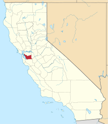 Alameda County map | |
| CDPs | ||
| Unincorporated communities | ||
| Annexed communities | ||
| Former townships |
| |
| Former communities | ||