Madison, Florida
Madison is a city in and the county seat of Madison County, on the central northern border of Florida, United States.[5] The population was 2,843 at the 2010 census.
Madison, Florida | |
|---|---|
 Madison City Hall | |
 Location in Madison County and the state of Florida | |
| Coordinates: 30°28′N 83°25′W | |
| Country | |
| State | |
| County | Madison |
| Government | |
| • Mayor | Jim Catron |
| Area | |
| • Total | 2.69 sq mi (6.96 km2) |
| • Land | 2.64 sq mi (6.83 km2) |
| • Water | 0.05 sq mi (0.14 km2) |
| Elevation | 194 ft (59 m) |
| Population (2010) | |
| • Total | 2,843 |
| • Estimate (2019)[2] | 2,763 |
| • Density | 1,048.18/sq mi (404.68/km2) |
| Time zone | UTC-5 (Eastern (EST)) |
| • Summer (DST) | UTC-4 (EDT) |
| ZIP codes | 32340-32341 |
| Area code(s) | 850 |
| FIPS code | 12-42425[3] |
| GNIS feature ID | 0286274[4] |
| Website | http://www.cityofmadisonfl.com/ |

History
The territory now known as Madison County was ruled at various times by Great Britain, Spain, and finally the United States. This area was developed for cotton plantations dependent on the labor of enslaved African Americans. After the Civil War and emancipation, many freedmen and their descendants stayed in the region, working as sharecroppers or tenant farmers.
Racial violence of whites against blacks increased after the Reconstruction era, reaching a peak near the turn of the 20th century. The following blacks were lynched in Madison: Charles Martin, 1 February 1899; both James Denson and his stepson, 7 January 1901; and an unidentified man, 9 February 1906.[6] Twelve blacks were lynched in the county outside the county seat. The late 19th century into the early 20th century was the peak of such murders: it was also the period of suppression of black voting by whites and passage of a state constitution that disenfranchised most black voters by raising barriers to voter registration. Blacks became virtually excluded from politics.
Geography
Madison is located at 30°28′N 83°25′W (30.466,-83.415).[7]
According to the United States Census Bureau, the city has a total area of 2.6 square miles (6.7 km2), of which 2.5 square miles (6.5 km2) is land and 0.1 square miles (0.3 km2) (1.94%) is water.
Demographics
| Historical population | |||
|---|---|---|---|
| Census | Pop. | %± | |
| 1860 | 423 | — | |
| 1870 | 924 | 118.4% | |
| 1880 | 756 | −18.2% | |
| 1890 | 781 | 3.3% | |
| 1900 | 849 | 8.7% | |
| 1910 | 1,560 | 83.7% | |
| 1920 | 1,952 | 25.1% | |
| 1930 | 2,189 | 12.1% | |
| 1940 | 2,730 | 24.7% | |
| 1950 | 3,150 | 15.4% | |
| 1960 | 3,239 | 2.8% | |
| 1970 | 3,737 | 15.4% | |
| 1980 | 3,487 | −6.7% | |
| 1990 | 3,345 | −4.1% | |
| 2000 | 3,061 | −8.5% | |
| 2010 | 2,843 | −7.1% | |
| Est. 2019 | 2,763 | [2] | −2.8% |
| U.S. Decennial Census[8] | |||
As of the census[3] of 2000, there were 3,061 people, 1,227 households, and 764 families residing in the city. The population density was 1,209.7 people per square mile (467.1/km2). There were 1,395 housing units at an average density of 551.3 per square mile (212.9/km2). The racial makeup of the city was 35.74% White, 62.43% African American, 0.10% Native American, 0.49% Asian, 0.03% Pacific Islander, 0.29% from other races, and 0.91% from two or more races. Hispanic or Latino of any race were 2.16% of the population.
There were 1,227 households, out of which 30.8% had children under the age of 18 living with them, 31.6% were married couples living together, 27.2% had a female householder with no husband present, and 37.7% were non-families. 33.0% of all households were made up of individuals, and 16.2% had someone living alone who was 65 years of age or older. The average household size was 2.44 and the average family size was 3.13.
In the city, the population was spread out, with 29.1% under the age of 18, 10.7% from 18 to 24, 24.9% from 25 to 44, 19.0% from 45 to 64, and 16.3% who were 65 years of age or older. The median age was 32 years. For every 100 females, there were 83.4 males. For every 100 females age 18 and over, there were 77.6 males.
The median income for a household in the city was $17,656, and the median income for a family was $22,988. Males had a median income of $24,101 versus $23,750 for females. The per capita income for the city was $10,041. About 37.0% of families and 39.9% of the population were below the poverty line, including 49.2% of those under age 18 and 28.9% of those age 65 or over.
Madison has the city manager-council form of government. City commissioners are elected from districts and serve for four years. The commission appoints the city manager and city clerk; a mayor-commissioner serves a one-year term. The City of Madison has a 14 officer police department, and a 9 firefighter fire department.
The 2008-2009 millage rate is 6.0484. The General Fund Budget is $7,344,592. Emphasis is placed on public safety, primarily expanding the Fire Department full-time personnel to implement a 24/48 hour, 3 shift coverage. In addition, the city plans to address abandoned and rundown property issues.
Climate
This area's climate is characterized by hot, humid summers and generally mild to cool winters. According to the Köppen Climate Classification system, Madison has a humid subtropical climate, abbreviated "Cfa" on climate maps.[9]
| Climate data for Madison, Florida | |||||||||||||
|---|---|---|---|---|---|---|---|---|---|---|---|---|---|
| Month | Jan | Feb | Mar | Apr | May | Jun | Jul | Aug | Sep | Oct | Nov | Dec | Year |
| Average high °C (°F) | 18.3 (64.9) |
19.8 (67.7) |
23.5 (74.3) |
26.9 (80.5) |
30.6 (87.1) |
32.7 (90.8) |
32.9 (91.3) |
32.9 (91.2) |
31.3 (88.4) |
27.3 (81.2) |
22.5 (72.5) |
18.7 (65.7) |
26.4 (79.6) |
| Average low °C (°F) | 5.8 (42.4) |
6.9 (44.4) |
9.9 (49.9) |
13 (56) |
17.4 (63.3) |
20.7 (69.3) |
21.9 (71.4) |
21.8 (71.3) |
20.2 (68.3) |
14.8 (58.6) |
9.6 (49.2) |
6.2 (43.2) |
14.1 (57.3) |
| Average precipitation cm (inches) | 10 (4) |
10 (4.1) |
12 (4.6) |
8.6 (3.4) |
8.4 (3.3) |
15 (5.8) |
17 (6.7) |
15 (6.1) |
12 (4.8) |
6.9 (2.7) |
6.6 (2.6) |
9.4 (3.7) |
131 (51.6) |
| Source: Weatherbase [10] | |||||||||||||
Education

Madison is served by two campuses of the District School Board of Madison County, Madison County Central School (PK-8) and Madison County High School.
North Florida Community College provides post-secondary instruction for six counties (Hamilton, Jefferson, Lafayette, Madison, Suwannee, and Taylor). In addition, St. Leo University provides university instruction at the junior-senior level.
 Madison County Central School
Media
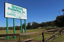
Area newspapers published by Greene Publishing are Madison County Carrier and The Madison Enterprise Recorder.
Transportation
Madison is served by Madison Shuttle, a bus route operated by Big Bend Transit.[11]
Freight service is provided by the Florida Gulf & Atlantic Railroad, which acquired most of the former CSX main line from Pensacola to Jacksonville on June 1, 2019.
Notable people
- LeGarrette Blount, NFL running back
- Lorenzo Cain, MLB player
- Geno Hayes, NFL linebacker
- Colin Kelly, World War II hero
- Jacobbi McDaniel, NFL defensive tackle
- Scott Phillips, drummer for the band Creed
- Jesse Solomon, NFL linebacker
- Chris Thompson, NFL running back
- Ernest Thomas was killed by a sheriff's posse in Madison in July 1949. He had fled arrest when accused of raping a white woman in Groveland, and was known as one of the Groveland Four. The other three were all wrongfully convicted; two were sentenced to death and a minor to life. Two of the convictions were overturned by the US Supreme Court, but one man was killed in what the sheriff claimed was an escape attempt in 1951 before a new trial. The second man was convicted again, but received a commutation of his death sentence. He was paroled a year before he died. The third man lived for more than four decades after being paroled. In 2017 the Florida legislature formally apologized to families of all the men and passed a resolution exonerating the four.
- Don Williams, stock car driver
References
- "2019 U.S. Gazetteer Files". United States Census Bureau. Retrieved July 2, 2020.
- "Population and Housing Unit Estimates". United States Census Bureau. May 24, 2020. Retrieved May 27, 2020.
- "U.S. Census website". United States Census Bureau. Retrieved 2008-01-31.
- "US Board on Geographic Names". United States Geological Survey. 2007-10-25. Retrieved 2008-01-31.
- "Find a County". National Association of Counties. Retrieved 2011-06-07.
- David Mark Greaves, "View From Here: Never Forget -(The Lynching List)", 3 February 2012; accessed 19 March 2018
- "US Gazetteer files: 2010, 2000, and 1990". United States Census Bureau. 2011-02-12. Retrieved 2011-04-23.
- "Census of Population and Housing". Census.gov. Retrieved June 4, 2015.
- Climate Summary for Madison, Florida
- "Weatherbase.com". Weatherbase. 2013. Retrieved on October 15, 2013.
- "Big Bend Transit | COORDINATED TRANSPORTATION SYSTEM OF MADISON COUNTY". www.bigbendtransit.org. Retrieved 2019-01-31.
External links
| Wikimedia Commons has media related to Madison, Florida. |
- City of Madison
- Greater Madison County Chamber of Commerce
- Madison County, Florida tourism site
- Madison Enterprise-Recorder newspaper that serves Madison, Florida is available in full-text with images in Florida Digital Newspaper Library
Municipalities and communities of Madison County, Florida, United States | ||
|---|---|---|
| City | 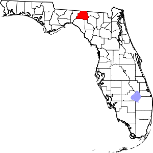 | |
| Towns | ||
| Unincorporated communities | ||
| Authority control |
|
|---|